
| WILLOW RUN DETROIT MI |
| |
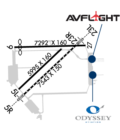
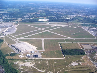
| Lat: N 4214.4 Long: W 08331.9 Elev: 716 Var: +06 Longest Runway: 7543 | ||
| Dept. ATIS: 127.42 Arr. ATIS: 127.42 AWOS: 132.35 Ground: 119.97 Tower: 125.27 | ||
| |||||||||||||||||||||||||||||||||||||||||||||||||||||||||||||||||||||
| |||||||||||||||||||||||||||||||||||||||||||||||||||||||||||||||||||||
| |||||||||||||||||||||||||||||||||||||||||||||||||||||||||||||||||||||
| |||||||||||||||||||||||||||||||||||||||||||||||||||||||||||||||||||||
| |||||||||||||||||||||||||||||||||||||||||||||||||||||||||||||||||||||
| |||||||||||||||||||||||||||||||||||||||||||||||||||||||||||||||||||||
| Rwy | Rwy | |||||||
| 5996x160 | 5996' | 5996x160 | 5996' | |||||
| 7543x150 | 7543' | 109.50 - 052° | 7543x150 | 7543' | 109.50 - 232° | |||
| 7292x160 | 6716' | 7292x160 | 7292' | |||||
| Runway ID | Single Wheel | Double Wheel | Double Tandem Wheel | Dual Double Wheel |
| 05L/23R | 35,000 | 45,000 | 90,000 | N/A |
| 05R/23L | 100,000 | 200,000 | 350,000 | 800,000 |
| 09/27 | 55,000 | 70,000 | 120,000 | N/A |
| These numbers are Advisory and are not limits. The Airport Manager should have more accurate Weight Limits | ||||
 Airport Diagram might not be current. | |
| Facility Name: | WILLOW RUN |
| City Name: | DETROIT |
| County: | WAYNE; AND WASHTENAW CO. |
| State abbrev: | MI |
| State Name: | MICHIGAN |
| Ownership: | PUBLICLY OWNED |
| Use: | OPEN TO THE PUBLIC |
| Owner's Name: | WAYNE COUNTY AIRPORT AUTHORITY |
| Address: | 11050 ROGELL DR # 602 |
| DETROIT, MI 48242-1144 | |
| Owner's Phone: | 734-485-6666 |
| Manager's Name: | MICHAEL FAWAZ, INTERIM AMGR |
| Address: | 801 WILLOW RUN AIRPORT |
| YPSILANTI, MI 48198-0899 | |
| Phone: | 734-485-6670 |
| FAA Region: | GREAT LAKES |
| FAA Field Office: | DET |
| Date | Sunrise | Sunset |
|---|---|---|
| 09/24/21 Friday | 7:23 | 19:28 |
| 09/25/21 Saturday | 7:24 | 19:27 |
| 09/26/21 Sunday | 7:25 | 19:25 |
| 09/27/21 Monday | 7:27 | 19:23 |
| 09/28/21 Tuesday | 7:28 | 19:21 |
| 09/29/21 Wednesday | 7:29 | 19:20 |
| 09/30/21 Thursday | 7:30 | 19:18 |
| 10/01/21 Friday | 7:31 | 19:16 |
| 10/02/21 Saturday | 7:32 | 19:14 |
| 10/03/21 Sunday | 7:33 | 19:13 |
| 10/04/21 Monday | 7:34 | 19:11 |
| 10/05/21 Tuesday | 7:35 | 19:09 |
| 10/06/21 Wednesday | 7:36 | 19:07 |
| 10/07/21 Thursday | 7:37 | 19:06 |
| Airport Attendance Schedule | CONTINUOUS |
| Airport Status | OPERATIONAL (This Status can change at any time - please check NOTAMS) |
| Airport Lighting Schedule | |
| Airport Storage Available | Tie Downs, Hanger |
| Extra Services Available | Air Freight, Avionics, Cargo Handling, Charter, Flight Instruction, Aircraft Rental, Aircraft Sales |
| Wind Indicator | YES - (lighted) |
| Control Tower | YES |
| CTAF Frequency | |
| Unicom Frequency | |
| Rotating Beacon Color | CLEAR-GREEN (Light Land Airport) |
| Segmented Circle | NO |
| Landing Fee | YES; LANDING FEE IS BASED ON ACFT GWT. |
| Airport Inspected | STATE - performed by FAA AIRPORTS FIELD PERSONNEL |
| Inspection Date | 11/06/2019 |
| Type of Fuel Available | Grade 100LL, JET A (freeze point -40C) |
| Airframe Repair Service | MAJOR |
| Power Plant Repair Service | MAJOR |
| Latitude | N4214.4 |
| Longitude | W08331.9 (ESTIMATED) |
| Arpt Elevation | 715ft (SURVEYED) |
| Magnetic Variation | 06W |
| 24 miles SW | of DETROIT |
| Traffic Pattern Altitude | |
| Sectional Chart | DETROIT |
| Operations (Reported) | Yearly | Avg. Daily |
|---|---|---|
| General Aviation Transient | 24577 | 67 |
| General Aviation Local | 27384 | 75 |
| Air Taxi | 7933 | 22 |
| Commerical | 2979 | 8 |
| Commuter | 0 | 0 |
| Military | 521 | 1 |
| Aircraft based on Field | |
|---|---|
| General Aviation Singles | 67 |
| General Aviation Multi | 17 |
| Jet Aircraft | 49 |
| General Aviation Helicopters | 6 |
| Military Aircraft | 0 |
| Gliders | 0 |
| Ultralights | 0 |
| FSS on field | NO |
| FSS tie-in | LANSING |
| FSS Phone | 1-800-WX-BRIEF |
| Who issues Notams | YIP |
| Notam D service at airport | YES |
| ARTCC Name | CLEVELAND |
| Airport Certification | ARFF INDEX E SVC AVBL ON REQUEST CALL 734-485-6669. |
| Aircraft Rescue & Firefighting Index | AIRPORT HAS A CERTIFICATE UNDER CFR PART 139 |
| Airport of Entry | No |
| Custom Landing Rights | YES; US CUSTOMS USER FEE ARPT. ALL BILLING THRU WAYNE CO ARPT AUTHORITY; FOR CUSTOMS CLNC 1 HR MIN ADVANCE NOTIFICATION REQD. PILOTS MUST CTC U.S. CUSTOMS ON 313-226-3140; RQ FOR CUSTOMS SVC BY FAA FLIGHT PLAN IS NOT ACCEPTED. |
| Joint Civil/Military | No |
| Military Landing rights | YES |
| NATIONAL PLAN OF INTEGRATED AIRPORT SYSTEMS (NPIAS) |
| GRANT AGREEMENTS UNDER FAAP/ADAP/AIP |
| SURPLUS PROPERTY AGREEMENT UNDER PUBLIC LAW 289 |
| SURPLUS PROPERTY AGREEMENT UNDER REGULATION 16-WAA |
| OBLIGATIONS ASSUMED BY TRANSFER |
| ASSURANCES PURSUANT TO TITLE VI, CIVIL RIGHTS ACT OF 1964 |
| BIRDS ON & INVOF ARPT. |
| CLSD TO SKEDD ACR OPS GTR THAN 9 PSGR SEATS. 72 HRS PPR FOR UNSKED ACR OPS WITH MORE THAN 30 PSGR SEATS CALL ARPT OPS MGR 734-485-6670. |
| LRA ARPT; ADCUS 734-942-9000. |
| CUST AVBL 24 HRS, MON - FRI AND ON CALL FROM DTW ON WKEND. |
| HELICOPTER TKOFS & LDGS ON THE SOUTH RAMP PROHIBITED, TAXI ONLY. |
| CONDS NOT MNT OUTSIDE M-F, 0800-1600,DTW AIRFIELD OPS (734-942-3685) PROVIDES DLY INSPECTIONS AND IS ON CALL FOR WX OR INCIDENTS OFF HRS. |
| RWY 05L/ 23RPAVEMENT CONDITION BASED ON RESULTS FROM PAVEMENT CONDITION INDEX (PCI) REPORT. |
| RWY 09/2 7 PAVEMENT COND BASED ON RESULTS FM PAVEMENT COND INDEX (PCI) REPORT. |
| RWY 09/2 7 ONLY THE 80' CENTER PORTION OF THE RY IS GRVD. |
Airport Communications & Frequencies:
| |||||||||||||||||||||
| Runway: 05L | Runway: 23R | ||
| Mag heading: | 53° | Mag heading: | 233° |
| Rwy Slope: | -.13% Down | Rwy Slope: | .13% Up |
| Approach: | Approach: | ||
| Pattern: | Left Traffic | Pattern: | Left Traffic |
| Markings: | NONPRECISION INSTRUMENT | Markings: | NONPRECISION INSTRUMENT |
| Marking Condition: | GOOD | Marking Condition: | GOOD |
| Arresting Dev: | Arresting Dev: | ||
| Lat & Long: | N4213.9 W08332.5 | Lat. & Long.: | N4214.6 W08331.5 |
| Elev: | 714.9 ft. MSL | Elev: | 707.2 ft. MSL |
| TCH: | 50 ft. AGL | TCH: | 50 ft. AGL |
| Visual Glide Path: | 3.00 degrees | Visual Glide Path: | 3.00 degrees |
| Displaced Threshold: | No | Displaced Threshold: | No |
| Touchdown Zone: | YES | Touchdown Zone: | YES |
| Touchdown Elev.: | 715.5 feet | Touchdown Elev.: | 712.0 feet |
| Visual Glide Slope: | 4-Light PAPI on LEFT side of Runway | Visual Glide Slope: | 4-Light PAPI on LEFT side of Runway |
| RVR Equipment: | RVR Equipment: | ||
| RVV Equipment: | NO | RVV Equipment: | NO |
| Approach Lights: | Approach Lights: | ||
| REIL: | NO | REIL: | NO |
| Centerline Lights: | NO | Centerline Lights: | NO |
| Touchdown lights: | NO | Touchdown lights: | NO |
| Runway Category: | Runway with a Non-precision Approach having visibility minimums greater than 3/4 mile | Runway Category: | Runway with a Non-precision Approach having visibility minimums greater than 3/4 mile |
| Declared Distances: | TORA:5996' TODA:5996' ASDA:5996' LDA:5996' | Declared Distances: | TORA:5996' TODA:5996' ASDA:5596' LDA:5596' |
| Obstructions: | TREES | Obstructions: | TREES |
| Marked: | NOT Marked/Lighted | Marked: | NOT Marked/Lighted |
| Clearance slope: | 21:1 | Clearance slope: | 34:1 |
| Obstruction height: | 60 feet AGL | Obstruction height: | 66 feet AGL |
| Dist. from runway: | 1490 feet | Dist. from runway: | 2473 feet |
| Centerline offset: | 224 left of centerline | Centerline offset: | 540 feet right of centerline |
| Comments: | Comments: |
| Runway: 05R | Runway: 23L | ||
| Mag heading: | 53° | Mag heading: | 233° |
| Rwy Slope: | -.17% Down | Rwy Slope: | .17% Up |
| Approach: | ILS/DME | Approach: | ILS/DME |
| Pattern: | Left Traffic | Pattern: | Left Traffic |
| Markings: | PRECISION INSTRUMENT | Markings: | PRECISION INSTRUMENT |
| Marking Condition: | GOOD | Marking Condition: | GOOD |
| Arresting Dev: | Arresting Dev: | ||
| Lat & Long: | N4213.8 W08332.4 | Lat. & Long.: | N4214.7 W08331.2 |
| Elev: | 714.3 ft. MSL | Elev: | 701.5 ft. MSL |
| TCH: | TCH: | 56 ft. AGL | |
| Visual Glide Path: | Visual Glide Path: | 3.00 degrees | |
| Displaced Threshold: | No | Displaced Threshold: | No |
| Touchdown Zone: | YES | Touchdown Zone: | YES |
| Touchdown Elev.: | 715.7 feet | Touchdown Elev.: | 710.1 feet |
| Visual Glide Slope: | Visual Glide Slope: | 4-Light PAPI on LEFT side of Runway | |
| RVR Equipment: | TOUCHDOWN | RVR Equipment: | ROLLOUT |
| RVV Equipment: | NO | RVV Equipment: | NO |
| Approach Lights: | MALSR - 1,400 foot medium intensity approach lighting system with runway alignment indicator lights | Approach Lights: | MALSR - 1,400 foot medium intensity approach lighting system with runway alignment indicator lights |
| REIL: | NO | REIL: | NO |
| Centerline Lights: | YES | Centerline Lights: | YES |
| Touchdown lights: | YES | Touchdown lights: | NO |
| Runway Category: | Precision Instrument Runway | Runway Category: | Precision Instrument Runway |
| Declared Distances: | TORA:7543' TODA:7543' ASDA:7543' LDA:7543' | Declared Distances: | TORA:7543' TODA:7543' ASDA:7543' LDA:7543' |
| Obstructions: | TREE | Obstructions: | TREE |
| Marked: | NOT Marked/Lighted | Marked: | NOT Marked/Lighted |
| Clearance slope: | 30:1 | Clearance slope: | 29:1 |
| Obstruction height: | 74 feet AGL | Obstruction height: | 39 feet AGL |
| Dist. from runway: | 2434 feet | Dist. from runway: | 1387 feet |
| Centerline offset: | 817 right of centerline | Centerline offset: | 674 feet right of centerline |
| Comments: | Comments: |
| Runway: 09 | Runway: 27 | ||
| Mag heading: | 95° | Mag heading: | 275° |
| Rwy Slope: | -.22% Down | Rwy Slope: | .22% Up |
| Approach: | Approach: | ||
| Pattern: | Left Traffic | Pattern: | Left Traffic |
| Markings: | NONPRECISION INSTRUMENT | Markings: | NONPRECISION INSTRUMENT |
| Marking Condition: | GOOD | Marking Condition: | GOOD |
| Arresting Dev: | Arresting Dev: | ||
| Lat & Long: | N4214.6 W08332.6 | Lat. & Long.: | N4214.7 W08331.0 |
| Elev: | 715.4 ft. MSL | Elev: | 699.4 ft. MSL |
| TCH: | 55 ft. AGL | TCH: | |
| Visual Glide Path: | 3.04 degrees | Visual Glide Path: | |
| Displaced Threshold: | 576 feet | Displaced Threshold: | No |
| Touchdown Zone: | YES | Touchdown Zone: | YES |
| Touchdown Elev.: | 714.9 feet | Touchdown Elev.: | 708.3 feet |
| Visual Glide Slope: | 4-Light PAPI on LEFT side of Runway | Visual Glide Slope: | |
| RVR Equipment: | RVR Equipment: | ||
| RVV Equipment: | NO | RVV Equipment: | NO |
| Approach Lights: | Approach Lights: | ||
| REIL: | NO | REIL: | NO |
| Centerline Lights: | NO | Centerline Lights: | NO |
| Touchdown lights: | NO | Touchdown lights: | NO |
| Runway Category: | Runway with a Non-precision Approach having visibility minimums greater than 3/4 mile | Runway Category: | Runway with a Visual Approach |
| Declared Distances: | TORA:7292' TODA:7292' ASDA:7292' LDA:6716' | Declared Distances: | TORA:7292' TODA:7292' ASDA:7292' LDA:7292' |
| Obstructions: | ROAD | Obstructions: | |
| Marked: | NOT Marked/Lighted | Marked: | |
| Clearance slope: | 14:1; RUNWAY 9 DISPLACED THRESHOLD OBSTRUCTION CLEARANCE 50:1 | Clearance slope: | 50:1 |
| Obstruction height: | 10 feet AGL | Obstruction height: | |
| Dist. from runway: | 312 feet | Dist. from runway: | |
| Centerline offset: | 267 right of centerline | Centerline offset: | |
| Comments: | Comments: |
Thanks for using FltPlan.com
all rights reserved © 1999-2021 by Flight Plan LLC