
| SANDUSKY CITY SANDUSKY MI |
| |
| Lat: N 4327.3 Long: W 08250.5 Elev: 777 Var: +08 Longest Runway: 3499 | ||
| CTAF: 122.8 | ||
| ||||||||||||||||||||||||||||||||||||||||||||
| ||||||||||||||||||||||||||||||||||||||||||||
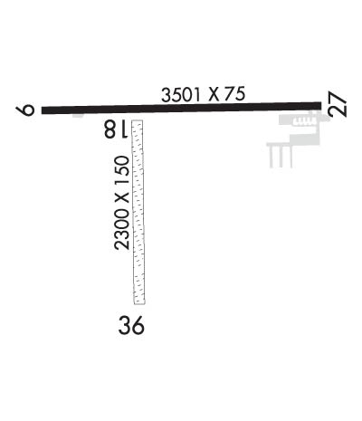
| Rwy | Rwy | |||||||
| 3499x75 | 3499' | 3499x75 | 3499' | |||||
| 2271x153 | 2271' | 2271x153 | 1897' | |||||
| Runway ID | Single Wheel | Double Wheel | Double Tandem Wheel | Dual Double Wheel |
| 10/28 | 16,000 | N/A | N/A | N/A |
| 18/36 | N/A | N/A | N/A | N/A |
| These numbers are Advisory and are not limits. The Airport Manager should have more accurate Weight Limits | ||||
 Airport Diagram might not be current. | |
| Facility Name: | SANDUSKY CITY |
| City Name: | SANDUSKY |
| County: | SANILAC |
| State abbrev: | MI |
| State Name: | MICHIGAN |
| Ownership: | PUBLICLY OWNED |
| Use: | OPEN TO THE PUBLIC |
| Owner's Name: | CITY OF SANDUSKY |
| Address: | 26 W SPEAKER ST |
| SANDUSKY, MI 48471-1299 | |
| Owner's Phone: | 810-648-4444 |
| Manager's Name: | DON JOHNSTON |
| Address: | CITY HALL, 26 W SPEAKER ST |
| SANDUSKY, MI 48471-1299 | |
| Phone: | 810-414-3009 |
| FAA Region: | GREAT LAKES |
| FAA Field Office: | DET |
| Date | Sunrise | Sunset |
|---|---|---|
| 06/08/26 Monday | 5:51 | 21:10 |
| 06/09/26 Tuesday | 5:51 | 21:11 |
| 06/10/26 Wednesday | 5:50 | 21:11 |
| 06/11/26 Thursday | 5:50 | 21:12 |
| 06/12/26 Friday | 5:50 | 21:12 |
| 06/13/26 Saturday | 5:50 | 21:13 |
| 06/14/26 Sunday | 5:50 | 21:13 |
| 06/15/26 Monday | 5:50 | 21:14 |
| 06/16/26 Tuesday | 5:50 | 21:14 |
| 06/17/26 Wednesday | 5:50 | 21:15 |
| 06/18/26 Thursday | 5:50 | 21:15 |
| 06/19/26 Friday | 5:50 | 21:15 |
| 06/20/26 Saturday | 5:50 | 21:15 |
| 06/21/26 Sunday | 5:50 | 21:16 |
| Airport Attendance Schedule | SAT-SUN ON CALL, MON-FRI 0900-1630; FOR SVC AFT HRS CALL AMGR. |
| Airport Status | OPERATIONAL (This Status can change at any time - please check NOTAMS) |
| Airport Lighting Schedule | ACTVT MIRL RWY 10/28 - CTAF. |
| Airport Storage Available | Tie Downs, Hanger |
| Extra Services Available | NONE |
| Wind Indicator | YES - (lighted) |
| Control Tower | NO |
| CTAF Frequency | 122.800 |
| Unicom Frequency | 122.800 |
| Rotating Beacon Color | WG |
| Segmented Circle | YES |
| Landing Fee | NO |
| Airport Inspected | STATE - performed by STATE AERONAUTICAL PERSONNEL |
| Inspection Date | 10/21/2024 |
| Type of Fuel Available | Grade 100LL |
| Airframe Repair Service | MAJOR |
| Power Plant Repair Service | MAJOR |
| Latitude | N4327.3 |
| Longitude | W08250.5 (ESTIMATED) |
| Arpt Elevation | 776ft (SURVEYED) |
| Magnetic Variation | 08W |
| 3 miles N | of SANDUSKY |
| Traffic Pattern Altitude | |
| Sectional Chart | DETROIT |
| Operations (Reported) | Yearly | Avg. Daily |
|---|---|---|
| General Aviation Transient | 0 | 0 |
| General Aviation Local | 0 | 0 |
| Air Taxi | 0 | 0 |
| Commerical | 0 | 0 |
| Commuter | 0 | 0 |
| Military | 0 | 0 |
| Aircraft based on Field | |
|---|---|
| General Aviation Singles | 0 |
| General Aviation Multi | 0 |
| Jet Aircraft | 0 |
| General Aviation Helicopters | 0 |
| Military Aircraft | 0 |
| Gliders | 0 |
| Ultralights | 0 |
| FSS on field | NO |
| FSS tie-in | LANSING |
| FSS Phone | 1-800-WX-BRIEF |
| Who issues Notams | LAN |
| Notam D service at airport | YES |
| ARTCC Name | CLEVELAND |
| Airport Certification | |
| Aircraft Rescue & Firefighting Index | None |
| Airport of Entry | No |
| Custom Landing Rights | No |
| Joint Civil/Military | No |
| Military Landing rights | YES |
| NATIONAL PLAN OF INTEGRATED AIRPORT SYSTEMS (NPIAS) |
| GRANT AGREEMENTS UNDER FAAP/ADAP/AIP |
| ASSURANCES PURSUANT TO TITLE VI, CIVIL RIGHTS ACT OF 1964 |
| +3 FT EMBANKMENT, 50 FT FM RWY 36 THR; -10 FT DITCH, 100 FT EAST OF RWY 18/36. |
| DEER & LRG BIRDS ON & INVOF ARPT. |
| FOR CD CTC CLEVELAND ARTCC AT 440-774-0224/0490. |
| FOR AFT HRS ACES TO TRML BLDG CALL AMGR. |
Airport Communications & Frequencies:
| |||||||||
| Runway: 10 | Runway: 28 | ||
| Mag heading: | 97° | Mag heading: | 277° |
| Rwy Slope: | -.05% Down | Rwy Slope: | .05% Up |
| Approach: | Approach: | ||
| Pattern: | Left Traffic | Pattern: | Left Traffic |
| Markings: | NONPRECISION INSTRUMENT | Markings: | NONPRECISION INSTRUMENT |
| Marking Condition: | GOOD | Marking Condition: | GOOD |
| Arresting Dev: | Arresting Dev: | ||
| Lat & Long: | N4327.4 W08250.9 | Lat. & Long.: | N4327.4 W08250.1 |
| Elev: | 776.3 ft. MSL | Elev: | 774.4 ft. MSL |
| TCH: | 41 ft. AGL | TCH: | 39 ft. AGL |
| Visual Glide Path: | 3.00 degrees | Visual Glide Path: | 3.00 degrees |
| Displaced Threshold: | No | Displaced Threshold: | No |
| Touchdown Zone: | YES | Touchdown Zone: | YES |
| Touchdown Elev.: | 776.9 feet | Touchdown Elev.: | 776.9 feet |
| Visual Glide Slope: | 2-Light PAPI on LEFT side of Runway | Visual Glide Slope: | 2-Light PAPI on LEFT side of Runway |
| RVR Equipment: | RVR Equipment: | ||
| RVV Equipment: | NO | RVV Equipment: | NO |
| Approach Lights: | Approach Lights: | ||
| REIL: | YES | REIL: | NO |
| Centerline Lights: | NO | Centerline Lights: | NO |
| Touchdown lights: | NO | Touchdown lights: | NO |
| Runway Category: | Runway with a Non-precision Approach | Runway Category: | Runway with a Non-precision Approach |
| Declared Distances: | Declared Distances: |
| Runway: 18 | Runway: 36 | ||
| Mag heading: | 187° | Mag heading: | 7° |
| Rwy Slope: | -.07% Down | Rwy Slope: | .07% Up |
| Approach: | Approach: | ||
| Pattern: | Left Traffic | Pattern: | Left Traffic |
| Markings: | Markings: | ||
| Marking Condition: | 3 FT YELLOW CONES. | Marking Condition: | 3 FT YELLOW CONES. |
| Arresting Dev: | Arresting Dev: | ||
| Lat & Long: | N4327.4 W08250.6 | Lat. & Long.: | N4327.0 W08250.6 |
| Elev: | 774.4 ft. MSL | Elev: | 772.8 ft. MSL |
| TCH: | TCH: | ||
| Visual Glide Path: | Visual Glide Path: | ||
| Displaced Threshold: | No | Displaced Threshold: | 374 feet |
| Touchdown Zone: | YES | Touchdown Zone: | YES |
| Touchdown Elev.: | 774.9 feet | Touchdown Elev.: | 774.9 feet |
| Visual Glide Slope: | Visual Glide Slope: | ||
| RVR Equipment: | RVR Equipment: | ||
| RVV Equipment: | NO | RVV Equipment: | NO |
| Approach Lights: | Approach Lights: | ||
| REIL: | NO | REIL: | NO |
| Centerline Lights: | NO | Centerline Lights: | NO |
| Touchdown lights: | NO | Touchdown lights: | NO |
| Runway Category: | Runway with a Visual Approach | Runway Category: | Runway with a Visual Approach |
| Declared Distances: | Declared Distances: | ||
| Obstructions: | Obstructions: | ROAD | |
| Marked: | Marked: | NOT Marked/Lighted | |
| Clearance slope: | 20:1 | Clearance slope: | 3:1; APCH RATIO 6:1 TO DTHR OVR 63 FT TREE, 380 FT DIST, 150 FT R. |
| Obstruction height: | Obstruction height: | 17 feet AGL | |
| Dist. from runway: | Dist. from runway: | 58 feet | |
| Centerline offset: | Centerline offset: | 125 feet right of centerline | |
| Comments: | Comments: |
Thanks for using FltPlan.com
all rights reserved © 1999-2026 by Flight Plan LLC
