
| BLOYER FIELD TOMAH WI |
| |
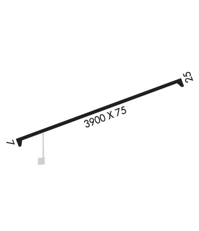
| Lat: N 4358.6 Long: W 09028.8 Elev: 966 Var: -00 Longest Runway: 3900 | ||
| CTAF: 122.9 | ||
| ||||||
|
| Rwy | Rwy | |||||||
| 3900x75 | 3900' | 3900x75 | 3900' | |||||
| Runway ID | Single Wheel | Double Wheel | Double Tandem Wheel | Dual Double Wheel |
| 07/25 | N/A | N/A | N/A | N/A |
| These numbers are Advisory and are not limits. The Airport Manager should have more accurate Weight Limits | ||||
 Airport Diagram might not be current. | |
| Facility Name: | BLOYER FLD |
| City Name: | TOMAH |
| County: | MONROE |
| State abbrev: | WI |
| State Name: | WISCONSIN |
| Ownership: | PUBLICLY OWNED |
| Use: | OPEN TO THE PUBLIC |
| Owner's Name: | CITY OF TOMAH |
| Address: | 819 SUPERIOR AVE |
| TOMAH, WI 54660 | |
| Owner's Phone: | 608-374-7440 |
| Manager's Name: | JOE KUBE |
| Address: | 819 SUPERIOR AVE. |
| TOMAH, WI 54660 | |
| Phone: | 608-344-1626 |
| FAA Region: | GREAT LAKES |
| FAA Field Office: | CHI |
| Date | Sunrise | Sunset |
|---|---|---|
| 06/12/26 Friday | 5:19 | 20:45 |
| 06/13/26 Saturday | 5:19 | 20:45 |
| 06/14/26 Sunday | 5:18 | 20:46 |
| 06/15/26 Monday | 5:18 | 20:46 |
| 06/16/26 Tuesday | 5:18 | 20:47 |
| 06/17/26 Wednesday | 5:19 | 20:47 |
| 06/18/26 Thursday | 5:19 | 20:47 |
| 06/19/26 Friday | 5:19 | 20:48 |
| 06/20/26 Saturday | 5:19 | 20:48 |
| 06/21/26 Sunday | 5:19 | 20:48 |
| 06/22/26 Monday | 5:19 | 20:48 |
| 06/23/26 Tuesday | 5:20 | 20:49 |
| 06/24/26 Wednesday | 5:20 | 20:49 |
| 06/25/26 Thursday | 5:20 | 20:49 |
| Airport Attendance Schedule | UNATTENDED |
| Airport Status | OPERATIONAL (This Status can change at any time - please check NOTAMS) |
| Airport Lighting Schedule | ACTVT REIL RWY 07/25; PAPI RYS 07/25; MIRL RWY 07/25 - CTAF. MIRL RWY 07/25 PRESET TO LOW SS-SR, TO INCR INTST - CTAF. |
| Airport Storage Available | Tie Downs |
| Extra Services Available | NONE |
| Wind Indicator | YES - (lighted) |
| Control Tower | NO |
| CTAF Frequency | 122.900 |
| Unicom Frequency | |
| Rotating Beacon Color | WG |
| Segmented Circle | YES |
| Landing Fee | NO |
| Airport Inspected | STATE - performed by STATE AERONAUTICAL PERSONNEL |
| Inspection Date | 06/04/2025 |
| Type of Fuel Available | Grade 100LL; -10SELF SVC FUEL AVBL H24 VIA CREDIT CARD. |
| Airframe Repair Service | NONE |
| Power Plant Repair Service | NONE |
| Latitude | N4358.6 |
| Longitude | W09028.8 (ESTIMATED) |
| Arpt Elevation | 966ft (SURVEYED) |
| Magnetic Variation | 00E |
| 1 miles E | of TOMAH |
| Traffic Pattern Altitude | |
| Sectional Chart | CHICAGO |
| Operations (Reported) | Yearly | Avg. Daily |
|---|---|---|
| General Aviation Transient | 0 | 0 |
| General Aviation Local | 0 | 0 |
| Air Taxi | 0 | 0 |
| Commerical | 0 | 0 |
| Commuter | 0 | 0 |
| Military | 0 | 0 |
| Aircraft based on Field | |
|---|---|
| General Aviation Singles | 0 |
| General Aviation Multi | 0 |
| Jet Aircraft | 0 |
| General Aviation Helicopters | 0 |
| Military Aircraft | 0 |
| Gliders | 0 |
| Ultralights | 0 |
| FSS on field | NO |
| FSS tie-in | GREEN BAY |
| FSS Phone | 1-800-WX-BRIEF |
| Who issues Notams | GRB |
| Notam D service at airport | YES |
| ARTCC Name | CHICAGO |
| Airport Certification | |
| Aircraft Rescue & Firefighting Index | None |
| Airport of Entry | No |
| Custom Landing Rights | No |
| Joint Civil/Military | No |
| Military Landing rights | No |
| DEER & BIRDS ON & INVOF AIRPORT. |
| FOR CD CTC CHICAGO ARTCC AT 630-906-8921. |
Airport Communications & Frequencies:
| |||||||||||||||
| Runway: 07 | Runway: 25 | ||
| Mag heading: | N/A | Mag heading: | N/A |
| Rwy Slope: | -.11% Down | Rwy Slope: | .11% Up |
| Approach: | Approach: | ||
| Pattern: | Left Traffic | Pattern: | Left Traffic |
| Markings: | NONPRECISION INSTRUMENT | Markings: | NONPRECISION INSTRUMENT |
| Marking Condition: | GOOD | Marking Condition: | GOOD |
| Arresting Dev: | Arresting Dev: | ||
| Lat & Long: | N4358.5 W09029.2 | Lat. & Long.: | N4358.7 W09028.4 |
| Elev: | 965.8 ft. MSL | Elev: | 961.6 ft. MSL |
| TCH: | 33 ft. AGL | TCH: | 35 ft. AGL |
| Visual Glide Path: | 3.00 degrees | Visual Glide Path: | 3.00 degrees |
| Displaced Threshold: | No | Displaced Threshold: | No |
| Touchdown Zone: | YES | Touchdown Zone: | YES |
| Touchdown Elev.: | 966.1 feet | Touchdown Elev.: | 966.0 feet |
| Visual Glide Slope: | 2-Light PAPI on LEFT side of Runway | Visual Glide Slope: | 2-Light PAPI on LEFT side of Runway |
| RVR Equipment: | RVR Equipment: | ||
| RVV Equipment: | NO | RVV Equipment: | NO |
| Approach Lights: | Approach Lights: | ||
| REIL: | YES | REIL: | YES |
| Centerline Lights: | NO | Centerline Lights: | NO |
| Touchdown lights: | NO | Touchdown lights: | NO |
| Runway Category: | Runway with a Non-precision Approach | Runway Category: | Runway with a Non-precision Approach |
| Declared Distances: | Declared Distances: | ||
| Obstructions: | Obstructions: | TREES | |
| Marked: | Marked: | NOT Marked/Lighted | |
| Clearance slope: | 20:1 | Clearance slope: | 15:1 |
| Obstruction height: | Obstruction height: | 30 feet AGL | |
| Dist. from runway: | Dist. from runway: | 675 feet | |
| Centerline offset: | Centerline offset: | 150 feet left of centerline | |
| Comments: | Comments: |
Thanks for using FltPlan.com
all rights reserved © 1999-2026 by Flight Plan LLC
