
| WAUTOMA MUNI WAUTOMA WI |
| |
| Lat: N 4402.6 Long: W 08918.3 Elev: 859 Var: +02 Longest Runway: 3300 | ||
| AWOS: 119.47 CTAF: 122.8 | ||
| ||||||||||||||||||||||||||||||||
| ||||||||||||||||||||||||||||||||
| ||||||||||||||||||||||||||||||||
| Rwy | Rwy | |||||||
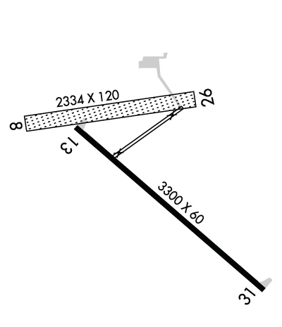
| 2334x120 | 2334' | 2334x120 | 2334' | |||||
| 3300x60 | 3300' | 3300x60 | 3300' | |||||
| Runway ID | Single Wheel | Double Wheel | Double Tandem Wheel | Dual Double Wheel |
| 08/26 | N/A | N/A | N/A | N/A |
| 13/31 | 12,500 | N/A | N/A | N/A |
| These numbers are Advisory and are not limits. The Airport Manager should have more accurate Weight Limits | ||||
 Airport Diagram might not be current. | |
| Facility Name: | WAUTOMA MUNI |
| City Name: | WAUTOMA |
| County: | WAUSHARA |
| State abbrev: | WI |
| State Name: | WISCONSIN |
| Ownership: | PUBLICLY OWNED |
| Use: | OPEN TO THE PUBLIC |
| Owner's Name: | CITY OF WAUTOMA |
| Address: | CITY HALL |
| WAUTOMA, WI 54982 | |
| Owner's Phone: | 920-787-4044 |
| Manager's Name: | RICHARD JORGENSEN |
| Address: | W8471 COTTONVILLE DRIVE |
| WAUTOMA, WI 54982 | |
| Phone: | 920-787-3030 |
| FAA Region: | GREAT LAKES |
| FAA Field Office: | CHI |
| Date | Sunrise | Sunset |
|---|---|---|
| 06/12/26 Friday | 5:14 | 20:41 |
| 06/13/26 Saturday | 5:14 | 20:41 |
| 06/14/26 Sunday | 5:14 | 20:41 |
| 06/15/26 Monday | 5:14 | 20:42 |
| 06/16/26 Tuesday | 5:14 | 20:42 |
| 06/17/26 Wednesday | 5:14 | 20:43 |
| 06/18/26 Thursday | 5:14 | 20:43 |
| 06/19/26 Friday | 5:14 | 20:43 |
| 06/20/26 Saturday | 5:14 | 20:44 |
| 06/21/26 Sunday | 5:14 | 20:44 |
| 06/22/26 Monday | 5:14 | 20:44 |
| 06/23/26 Tuesday | 5:15 | 20:44 |
| 06/24/26 Wednesday | 5:15 | 20:44 |
| 06/25/26 Thursday | 5:15 | 20:44 |
| Airport Attendance Schedule | 7 Days A Week 0700-1900 |
| Airport Status | OPERATIONAL (This Status can change at any time - please check NOTAMS) |
| Airport Lighting Schedule | MIRL RWY 13/31 PRESET TO LOW SS-SR; TO INCR INTST AND ACTVT - CTAF. |
| Airport Storage Available | Tie Downs, Hanger |
| Extra Services Available | Flight Instruction |
| Wind Indicator | YES - (lighted) |
| Control Tower | NO |
| CTAF Frequency | 122.800 |
| Unicom Frequency | 122.800 |
| Rotating Beacon Color | WG |
| Segmented Circle | YES |
| Landing Fee | NO |
| Airport Inspected | STATE - performed by STATE AERONAUTICAL PERSONNEL |
| Inspection Date | 06/06/2024 |
| Type of Fuel Available | Grade 100LL; -1024 HR SELF SVC FUEL AVBL WITH CREDIT CARD. |
| Airframe Repair Service | MINOR |
| Power Plant Repair Service | MAJOR |
| Latitude | N4402.6 |
| Longitude | W08918.3 (ESTIMATED) |
| Arpt Elevation | 859ft (SURVEYED) |
| Magnetic Variation | 02W |
| 2 miles SW | of WAUTOMA |
| Traffic Pattern Altitude | |
| Sectional Chart | GREEN BAY |
| Operations (Reported) | Yearly | Avg. Daily |
|---|---|---|
| General Aviation Transient | 0 | 0 |
| General Aviation Local | 0 | 0 |
| Air Taxi | 0 | 0 |
| Commerical | 0 | 0 |
| Commuter | 0 | 0 |
| Military | 0 | 0 |
| Aircraft based on Field | |
|---|---|
| General Aviation Singles | 0 |
| General Aviation Multi | 0 |
| Jet Aircraft | 0 |
| General Aviation Helicopters | 0 |
| Military Aircraft | 0 |
| Gliders | 0 |
| Ultralights | 0 |
| FSS on field | NO |
| FSS tie-in | GREEN BAY |
| FSS Phone | 1-800-WX-BRIEF |
| Who issues Notams | GRB |
| Notam D service at airport | YES |
| ARTCC Name | CHICAGO |
| Airport Certification | |
| Aircraft Rescue & Firefighting Index | None |
| Airport of Entry | No |
| Custom Landing Rights | No |
| Joint Civil/Military | No |
| Military Landing rights | No |
| NATIONAL PLAN OF INTEGRATED AIRPORT SYSTEMS (NPIAS) |
| GRANT AGREEMENT HAS EXPIRED; HOWEVER, AGREEMENT REMAINS IN EFFECT FOR THIS FACILITY AS LONG AS IT IS PUBLIC USE. |
| WATERFOWL AND DEER ON AND INVOF ARPT. |
| ULTRALIGHT ACTIVITY ON & INVOF ARPT. |
| FOR CD CTC CHICAGO ARTCC AT 630-906-8921. |
| RWY 08/2 6 RY 08/26 CLSD WINTER MONTHS EXCEPT FOR SKI EQUIPPED ACFT. E 430 FT CLSD IN WINTER. |
Airport Communications & Frequencies:
| ||||||||||||||
| Runway: 08 | Runway: 26 | ||
| Mag heading: | 85° | Mag heading: | 265° |
| Rwy Slope: | -.09% Down | Rwy Slope: | .09% Up |
| Approach: | Approach: | ||
| Pattern: | Left Traffic | Pattern: | Left Traffic |
| Markings: | NONE | Markings: | NONE |
| Marking Condition: | MKD WITH WHITE HALF BARRELS. | Marking Condition: | MKD WITH WHITE HALF BARRELS. |
| Arresting Dev: | Arresting Dev: | ||
| Lat & Long: | N4402.7 W08918.7 | Lat. & Long.: | N4402.7 W08918.2 |
| Elev: | 858.9 ft. MSL | Elev: | 856.9 ft. MSL |
| TCH: | TCH: | ||
| Visual Glide Path: | Visual Glide Path: | ||
| Displaced Threshold: | No | Displaced Threshold: | No |
| Touchdown Zone: | YES | Touchdown Zone: | YES |
| Touchdown Elev.: | 858.9 feet | Touchdown Elev.: | 858.9 feet |
| Visual Glide Slope: | Visual Glide Slope: | ||
| RVR Equipment: | RVR Equipment: | ||
| RVV Equipment: | NO | RVV Equipment: | NO |
| Approach Lights: | Approach Lights: | ||
| REIL: | NO | REIL: | NO |
| Centerline Lights: | NO | Centerline Lights: | NO |
| Touchdown lights: | NO | Touchdown lights: | NO |
| Runway Category: | Runway with a Visual Approach | Runway Category: | Runway with a Visual Approach |
| Declared Distances: | Declared Distances: | ||
| Obstructions: | TREES | Obstructions: | |
| Marked: | NOT Marked/Lighted | Marked: | |
| Clearance slope: | 14:1 | Clearance slope: | 20:1 |
| Obstruction height: | 60 feet AGL | Obstruction height: | |
| Dist. from runway: | 850 feet | Dist. from runway: | |
| Centerline offset: | 75 right of centerline | Centerline offset: | |
| Comments: | Comments: |
| Runway: 13 | Runway: 31 | ||
| Mag heading: | 134° | Mag heading: | 314° |
| Rwy Slope: | -.08% Down | Rwy Slope: | .08% Up |
| Approach: | Approach: | ||
| Pattern: | Left Traffic | Pattern: | Left Traffic |
| Markings: | NONPRECISION INSTRUMENT | Markings: | NONPRECISION INSTRUMENT |
| Marking Condition: | GOOD | Marking Condition: | GOOD |
| Arresting Dev: | Arresting Dev: | ||
| Lat & Long: | N4402.7 W08918.5 | Lat. & Long.: | N4402.3 W08918.0 |
| Elev: | 858.5 ft. MSL | Elev: | 855.9 ft. MSL |
| TCH: | TCH: | ||
| Visual Glide Path: | Visual Glide Path: | ||
| Displaced Threshold: | No | Displaced Threshold: | No |
| Touchdown Zone: | YES | Touchdown Zone: | YES |
| Touchdown Elev.: | 859.0 feet | Touchdown Elev.: | 859.0 feet |
| Visual Glide Slope: | Visual Glide Slope: | ||
| RVR Equipment: | RVR Equipment: | ||
| RVV Equipment: | NO | RVV Equipment: | NO |
| Approach Lights: | Approach Lights: | ||
| REIL: | NO | REIL: | NO |
| Centerline Lights: | NO | Centerline Lights: | NO |
| Touchdown lights: | NO | Touchdown lights: | NO |
| Runway Category: | Runway with a Non-precision Approach | Runway Category: | Runway with a Non-precision Approach |
| Declared Distances: | Declared Distances: | ||
| Obstructions: | TREES | Obstructions: | TREE |
| Marked: | NOT Marked/Lighted | Marked: | NOT Marked/Lighted |
| Clearance slope: | 13:1 | Clearance slope: | 13:1 |
| Obstruction height: | 88 feet AGL | Obstruction height: | 67 feet AGL |
| Dist. from runway: | 1350 feet | Dist. from runway: | 1075 feet |
| Centerline offset: | 350 left of centerline | Centerline offset: | 275 feet left of centerline |
| Comments: | Comments: |
Thanks for using FltPlan.com
all rights reserved © 1999-2026 by Flight Plan LLC
