
| OAKLAND SOUTHWEST NEW HUDSON MI |
| |
| Lat: N 4230.2 Long: W 08337.4 Elev: 926 Var: +07 Longest Runway: 3128 | ||
| CTAF: 122.7 | ||
| ||||||
|
| Rwy | Rwy | |||||||
| 3128x40 | 2261' | 3128x40 | 2264' | |||||
| Runway ID | Single Wheel | Double Wheel | Double Tandem Wheel | Dual Double Wheel |
| 08/26 | N/A | N/A | N/A | N/A |
| These numbers are Advisory and are not limits. The Airport Manager should have more accurate Weight Limits | ||||
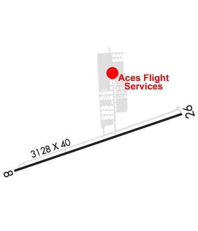 Airport Diagram might not be current. | |
| Facility Name: | OAKLAND SOUTHWEST |
| City Name: | NEW HUDSON |
| County: | OAKLAND |
| State abbrev: | MI |
| State Name: | MICHIGAN |
| Ownership: | PUBLICLY OWNED |
| Use: | OPEN TO THE PUBLIC |
| Owner's Name: | OAKLAND COUNTY |
| Address: | PO BOX 329 |
| NEW HUDSON, MI 48165-0329 | |
| Owner's Phone: | 248-437-2333 |
| Manager's Name: | CHERYL BUSH |
| Address: | 57751 PONTIAC TRL |
| NEW HUDSON, MI 48165-8700 | |
| Phone: | 248-437-2333 |
| FAA Region: | GREAT LAKES |
| FAA Field Office: | DET |
| Date | Sunrise | Sunset |
|---|---|---|
| 09/24/21 Friday | 7:24 | 19:29 |
| 09/25/21 Saturday | 7:25 | 19:27 |
| 09/26/21 Sunday | 7:26 | 19:25 |
| 09/27/21 Monday | 7:27 | 19:23 |
| 09/28/21 Tuesday | 7:28 | 19:22 |
| 09/29/21 Wednesday | 7:29 | 19:20 |
| 09/30/21 Thursday | 7:30 | 19:18 |
| 10/01/21 Friday | 7:31 | 19:16 |
| 10/02/21 Saturday | 7:32 | 19:15 |
| 10/03/21 Sunday | 7:34 | 19:13 |
| 10/04/21 Monday | 7:35 | 19:11 |
| 10/05/21 Tuesday | 7:36 | 19:09 |
| 10/06/21 Wednesday | 7:37 | 19:08 |
| 10/07/21 Thursday | 7:38 | 19:06 |
| Airport Attendance Schedule | MON-FRI 0830-1700, SAT-SUN ON CALL |
| Airport Status | OPERATIONAL (This Status can change at any time - please check NOTAMS) |
| Airport Lighting Schedule | ACTVT LIRL RWY 08/26 - CTAF. |
| Airport Storage Available | Tie Downs, Hanger |
| Extra Services Available | Flight Instruction, Aircraft Rental |
| Wind Indicator | YES - (lighted) |
| Control Tower | NO |
| CTAF Frequency | 122.700 |
| Unicom Frequency | 122.700 |
| Rotating Beacon Color | CLEAR-GREEN (Light Land Airport) |
| Segmented Circle | YES |
| Landing Fee | NO |
| Airport Inspected | STATE - performed by STATE AERONAUTICAL PERSONNEL |
| Inspection Date | 10/17/2018 |
| Type of Fuel Available | Grade 100LL |
| Airframe Repair Service | None |
| Power Plant Repair Service | None |
| Latitude | N4230.2 |
| Longitude | W08337.4 (ESTIMATED) |
| Arpt Elevation | 926ft (ESTIMATED) |
| Magnetic Variation | 07W |
| 1 miles SW | of NEW HUDSON |
| Traffic Pattern Altitude | |
| Sectional Chart | DETROIT |
| Operations (Reported) | Yearly | Avg. Daily |
|---|---|---|
| General Aviation Transient | 6500 | 18 |
| General Aviation Local | 6500 | 18 |
| Air Taxi | 0 | 0 |
| Commerical | 0 | 0 |
| Commuter | 0 | 0 |
| Military | 0 | 0 |
| Aircraft based on Field | |
|---|---|
| General Aviation Singles | 37 |
| General Aviation Multi | 2 |
| Jet Aircraft | 0 |
| General Aviation Helicopters | 1 |
| Military Aircraft | 0 |
| Gliders | 0 |
| Ultralights | 0 |
| FSS on field | NO |
| FSS tie-in | LANSING |
| FSS Phone | 1-800-WX-BRIEF |
| Who issues Notams | LAN |
| Notam D service at airport | YES |
| ARTCC Name | CLEVELAND |
| Airport Certification | |
| Aircraft Rescue & Firefighting Index | None |
| Airport of Entry | No |
| Custom Landing Rights | No |
| Joint Civil/Military | No |
| Military Landing rights | No |
| NATIONAL PLAN OF INTEGRATED AIRPORT SYSTEMS (NPIAS) |
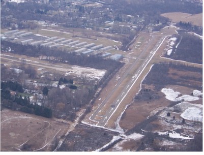
| TREES & BRUSH IN PRIMARY SFC 70-120 FT L & R. |
| FOR CD CTC DETROIT APCH AT 800-499-8181. |
| CRANE 2874 FT E APCH END RWY 26 (120FT AGL) FLAGGED NOT LGTD. |
| CRANE 2874 FT E APCH END RWY 26 (120FT AGL) FLAGGED NOT LGTD. |
| DEER & LRG BIRDS ON & INVOF ARPT. |
Airport Communications & Frequencies:
| ||||||||||||||
| Runway: 08 | Runway: 26 | ||
| Mag heading: | 78° | Mag heading: | 258° |
| Rwy Slope: | .17% Up | Rwy Slope: | -.17% Down |
| Approach: | Approach: | ||
| Pattern: | Left Traffic | Pattern: | Left Traffic |
| Markings: | BASIC | Markings: | BASIC |
| Marking Condition: | FAIR | Marking Condition: | FAIR |
| Arresting Dev: | Arresting Dev: | ||
| Lat & Long: | N4230.1 W08337.8 | Lat. & Long.: | N4230.3 W08337.1 |
| Elev: | 920.9 ft. MSL | Elev: | 926.1 ft. MSL |
| TCH: | 20 ft. AGL | TCH: | 19 ft. AGL |
| Visual Glide Path: | 4.00 degrees | Visual Glide Path: | 4.00 degrees |
| Displaced Threshold: | 867 feet | Displaced Threshold: | 864 feet |
| Touchdown Zone: | YES | Touchdown Zone: | YES |
| Touchdown Elev.: | 926.1 feet | Touchdown Elev.: | 926.1 feet |
| Visual Glide Slope: | 2-Box VASI on RIGHT side of Runway; VASI U/S INDEFLY. | Visual Glide Slope: | 2-Box VASI on LEFT side of Runway; VASI U/S INDEFLY. |
| RVR Equipment: | RVR Equipment: | ||
| RVV Equipment: | NO | RVV Equipment: | NO |
| Approach Lights: | Approach Lights: | ||
| REIL: | NO | REIL: | NO |
| Centerline Lights: | NO | Centerline Lights: | NO |
| Touchdown lights: | NO | Touchdown lights: | NO |
| Runway Category: | Runway with a Visual Approach | Runway Category: | Runway with a Visual Approach |
| Declared Distances: | Declared Distances: | ||
| Obstructions: | BRUSH | Obstructions: | TREES; +30 FT PLINE, 697 FT DIST; +20 FT TREES, 110 FT L; +15-50 FT TREES, MOST QUADS. |
| Marked: | NOT Marked/Lighted | Marked: | NOT Marked/Lighted |
| Clearance slope: | APCH RATIO 3:1 TO DTHR OVR +25 FT TREE, 75 FT DIST FM DTHR, 84 FT L. | Clearance slope: | APCH RATIO 0:1 TO DTHR OVR +35 FT TREE, 20 FT DIST FM DTHR, 115 FT L. |
| Obstruction height: | 20 feet AGL | Obstruction height: | 66 feet AGL |
| Dist. from runway: | 15 feet | Dist. from runway: | 201 feet |
| Centerline offset: | Centerline offset: | 145 feet right of centerline | |
| Comments: | -4 FT DITCH, 40 FT DIST FM THR; +5-15 FT BRUSH, SCATTERED. | Comments: | 20 FT BRUSH, 84 FT DIST, 110 FT L. |
Thanks for using FltPlan.com
all rights reserved © 1999-2021 by Flight Plan LLC