
| WEST BRANCH COMMUNITY WEST BRANCH MI |
| |
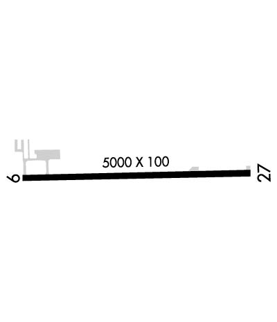
| Lat: N 4414.7 Long: W 08410.8 Elev: 882 Var: +06 Longest Runway: 5000 | ||
| CTAF: 122.8 | ||
| ||||||||||||||||||||||||||||||||||||||||||||
| ||||||||||||||||||||||||||||||||||||||||||||
| Rwy | Rwy | |||||||
| 5000x100 | 5000' | 5000x100 | 5000' | |||||
| Runway ID | Single Wheel | Double Wheel | Double Tandem Wheel | Dual Double Wheel |
| 09/27 | 26,000 | N/A | N/A | N/A |
| These numbers are Advisory and are not limits. The Airport Manager should have more accurate Weight Limits | ||||
 Airport Diagram might not be current. | |
| Facility Name: | WEST BRANCH COMMUNITY |
| City Name: | WEST BRANCH |
| County: | OGEMAW |
| State abbrev: | MI |
| State Name: | MICHIGAN |
| Ownership: | PUBLICLY OWNED |
| Use: | OPEN TO THE PUBLIC |
| Owner's Name: | CO OGEMAW CITY W BRANCH |
| Address: | 121 N 4TH ST |
| WEST BRANCH, MI 48661-1217 | |
| Owner's Phone: | 989-345-0500 |
| Manager's Name: | BEN EVERGREEN |
| Address: | PO BOX 183 |
| WEST BRANCH, MI 48661-0183 | |
| Phone: | 989-345-1453 |
| FAA Region: | GREAT LAKES |
| FAA Field Office: | DET |
| Date | Sunrise | Sunset |
|---|---|---|
| 06/08/26 Monday | 5:53 | 21:18 |
| 06/09/26 Tuesday | 5:53 | 21:19 |
| 06/10/26 Wednesday | 5:53 | 21:20 |
| 06/11/26 Thursday | 5:53 | 21:20 |
| 06/12/26 Friday | 5:52 | 21:21 |
| 06/13/26 Saturday | 5:52 | 21:21 |
| 06/14/26 Sunday | 5:52 | 21:22 |
| 06/15/26 Monday | 5:52 | 21:22 |
| 06/16/26 Tuesday | 5:52 | 21:23 |
| 06/17/26 Wednesday | 5:52 | 21:23 |
| 06/18/26 Thursday | 5:52 | 21:23 |
| 06/19/26 Friday | 5:52 | 21:24 |
| 06/20/26 Saturday | 5:53 | 21:24 |
| 06/21/26 Sunday | 5:53 | 21:24 |
| Airport Attendance Schedule | MON-FRI 0800-1700, SAT-SUN ON CALL; FOR SVC AFT HRS CALL AMGR SUBJ CALL-IN FEE. |
| Airport Status | OPERATIONAL (This Status can change at any time - please check NOTAMS) |
| Airport Lighting Schedule | ACTVT REIL RWY 09 & 27; PAPI RWY 09 & 27; MIRL RWY 09/27 - CTAF. PAPI RWY 09 & 27 OPR CONSLY SR-SS. |
| Airport Storage Available | Tie Downs, Hanger |
| Extra Services Available | NONE |
| Wind Indicator | YES - (lighted) |
| Control Tower | NO |
| CTAF Frequency | 122.800 |
| Unicom Frequency | 122.800 |
| Rotating Beacon Color | WG |
| Segmented Circle | YES |
| Landing Fee | NO |
| Airport Inspected | STATE - performed by STATE AERONAUTICAL PERSONNEL |
| Inspection Date | 11/03/2025 |
| Type of Fuel Available | Grade 100LL, JET A |
| Airframe Repair Service | NONE |
| Power Plant Repair Service | NONE |
| Latitude | N4414.7 |
| Longitude | W08410.8 (ESTIMATED) |
| Arpt Elevation | 882ft (SURVEYED) |
| Magnetic Variation | 06W |
| 3 miles SE | of WEST BRANCH |
| Traffic Pattern Altitude | |
| Sectional Chart | LAKE HURON |
| Operations (Reported) | Yearly | Avg. Daily |
|---|---|---|
| General Aviation Transient | 0 | 0 |
| General Aviation Local | 0 | 0 |
| Air Taxi | 0 | 0 |
| Commerical | 0 | 0 |
| Commuter | 0 | 0 |
| Military | 0 | 0 |
| Aircraft based on Field | |
|---|---|
| General Aviation Singles | 0 |
| General Aviation Multi | 0 |
| Jet Aircraft | 0 |
| General Aviation Helicopters | 0 |
| Military Aircraft | 0 |
| Gliders | 0 |
| Ultralights | 0 |
| FSS on field | NO |
| FSS tie-in | LANSING |
| FSS Phone | 1-800-WX-BRIEF |
| Who issues Notams | Y31 |
| Notam D service at airport | YES |
| ARTCC Name | MINNEAPOLIS |
| Airport Certification | |
| Aircraft Rescue & Firefighting Index | None |
| Airport of Entry | No |
| Custom Landing Rights | No |
| Joint Civil/Military | No |
| Military Landing rights | YES |
| NATIONAL PLAN OF INTEGRATED AIRPORT SYSTEMS (NPIAS) |
| GRANT AGREEMENTS UNDER FAAP/ADAP/AIP |
| ASSURANCES PURSUANT TO TITLE VI, CIVIL RIGHTS ACT OF 1964 |
| ADMIN BLDG ACES: 5-3-2-1-#. |
| FOR CD CTC MINNEAPOLIS ARTCC AT 651-463-5588. |
| DEER & LRG BIRDS ON & INVOF ARPT. |
Airport Communications & Frequencies:
| |||||||||
| Runway: 09 | Runway: 27 | ||
| Mag heading: | 95° | Mag heading: | 275° |
| Rwy Slope: | -.42% Down | Rwy Slope: | .42% Up |
| Approach: | Approach: | ||
| Pattern: | Left Traffic | Pattern: | Left Traffic |
| Markings: | NONPRECISION INSTRUMENT | Markings: | NONPRECISION INSTRUMENT |
| Marking Condition: | GOOD | Marking Condition: | GOOD |
| Arresting Dev: | Arresting Dev: | ||
| Lat & Long: | N4414.7 W08411.4 | Lat. & Long.: | N4414.7 W08410.2 |
| Elev: | 882.1 ft. MSL | Elev: | 860.9 ft. MSL |
| TCH: | 41 ft. AGL | TCH: | 41 ft. AGL |
| Visual Glide Path: | 3.00 degrees | Visual Glide Path: | 3.00 degrees |
| Displaced Threshold: | No | Displaced Threshold: | No |
| Touchdown Zone: | YES | Touchdown Zone: | YES |
| Touchdown Elev.: | 882.1 feet | Touchdown Elev.: | 876.5 feet |
| Visual Glide Slope: | 4-Light PAPI on LEFT side of Runway | Visual Glide Slope: | 4-Light PAPI on LEFT side of Runway |
| RVR Equipment: | RVR Equipment: | ||
| RVV Equipment: | NO | RVV Equipment: | NO |
| Approach Lights: | Approach Lights: | ||
| REIL: | YES | REIL: | YES |
| Centerline Lights: | NO | Centerline Lights: | NO |
| Touchdown lights: | NO | Touchdown lights: | NO |
| Runway Category: | Runway with a Non-precision Approach having visibility minimums greater than 3/4 mile | Runway Category: | Runway with a Non-precision Approach having visibility minimums greater than 3/4 mile |
| Declared Distances: | Declared Distances: | ||
| Obstructions: | Obstructions: | TREE | |
| Marked: | Marked: | NOT Marked/Lighted | |
| Clearance slope: | 34:1 | Clearance slope: | 31:1 |
| Obstruction height: | Obstruction height: | 70 feet AGL | |
| Dist. from runway: | Dist. from runway: | 2379 feet | |
| Centerline offset: | Centerline offset: | 592 feet right of centerline | |
| Comments: | Comments: |
Thanks for using FltPlan.com
all rights reserved © 1999-2026 by Flight Plan LLC
