
| MUNICIPAL-SOUTHWORTH AIRPORT CHETEK WI |
| |
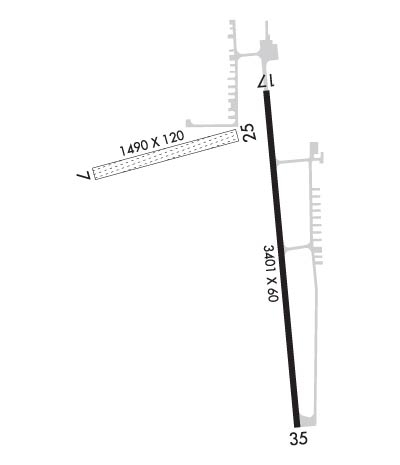
| Lat: N 4518.4 Long: W 09138.2 Elev: 1056 Var: -00 Longest Runway: 3401 | ||
| AWOS: 119.05 CTAF: 122.9 | ||
| ||||||||||||||||||||||||||||||||||||||||||||
| ||||||||||||||||||||||||||||||||||||||||||||
| ||||||||||||||||||||||||||||||||||||||||||||
| Rwy | Rwy | |||||||
| 1490x120 | 1299' | 1490x120 | 1290' | |||||
| 3401x60 | 2801' | 3401x60 | 3401' | |||||
| Runway ID | Single Wheel | Double Wheel | Double Tandem Wheel | Dual Double Wheel |
| 07/25 | N/A | N/A | N/A | N/A |
| 17/35 | N/A | N/A | N/A | N/A |
| These numbers are Advisory and are not limits. The Airport Manager should have more accurate Weight Limits | ||||
 Airport Diagram might not be current. | |
| Facility Name: | CHETEK MUNI-SOUTHWORTH |
| City Name: | CHETEK |
| County: | BARRON |
| State abbrev: | WI |
| State Name: | WISCONSIN |
| Ownership: | PUBLICLY OWNED |
| Use: | OPEN TO THE PUBLIC |
| Owner's Name: | CITY OF CHETEK |
| Address: | 220 STOUT ST |
| CHETEK, WI 54728 | |
| Owner's Phone: | 715-924-4838 |
| Manager's Name: | DAN KNAPP |
| Address: | P O BOX 194; EMAIL ADDRESS: DKNAPP@CITYOFCHETEK-WI.GOV (ALL LOWER CASE) |
| CHETEK, WI 54728 | |
| Phone: | (715) 642-0822 |
| FAA Region: | GREAT LAKES |
| FAA Field Office: | CHI |
| Date | Sunrise | Sunset |
|---|---|---|
| 09/24/21 Friday | 6:56 | 19:01 |
| 09/25/21 Saturday | 6:57 | 18:59 |
| 09/26/21 Sunday | 6:58 | 18:57 |
| 09/27/21 Monday | 6:59 | 18:55 |
| 09/28/21 Tuesday | 7:01 | 18:53 |
| 09/29/21 Wednesday | 7:02 | 18:51 |
| 09/30/21 Thursday | 7:03 | 18:49 |
| 10/01/21 Friday | 7:04 | 18:47 |
| 10/02/21 Saturday | 7:06 | 18:45 |
| 10/03/21 Sunday | 7:07 | 18:44 |
| 10/04/21 Monday | 7:08 | 18:42 |
| 10/05/21 Tuesday | 7:09 | 18:40 |
| 10/06/21 Wednesday | 7:11 | 18:38 |
| 10/07/21 Thursday | 7:12 | 18:36 |
| Airport Attendance Schedule | UNATTENDED |
| Airport Status | OPERATIONAL (This Status can change at any time - please check NOTAMS) |
| Airport Lighting Schedule | MIRL RY 17/35 PRESET ON LOW INTST, TO INCR INTST & ACTVT REIL RY 17/35; PAPI RY17/35 - CTAF. |
| Airport Storage Available | Tie Downs |
| Extra Services Available | NONE |
| Wind Indicator | YES - (lighted) |
| Control Tower | NO |
| CTAF Frequency | 122.900 |
| Unicom Frequency | |
| Rotating Beacon Color | CLEAR-GREEN (Light Land Airport) |
| Segmented Circle | YES |
| Landing Fee | NO |
| Airport Inspected | STATE - performed by STATE AERONAUTICAL PERSONNEL |
| Inspection Date | 07/23/2020 |
| Type of Fuel Available | Grade 100LL; -1024 HR SELF SERVICE FUEL. |
| Airframe Repair Service | MINOR |
| Power Plant Repair Service | MINOR |
| Latitude | N4518.4 |
| Longitude | W09138.2 (ESTIMATED) |
| Arpt Elevation | 1056ft (SURVEYED) |
| Magnetic Variation | 00E |
| 1 miles SE | of CHETEK |
| Traffic Pattern Altitude | |
| Sectional Chart | GREEN BAY |
| Operations (Reported) | Yearly | Avg. Daily |
|---|---|---|
| General Aviation Transient | 2400 | 7 |
| General Aviation Local | 4800 | 13 |
| Air Taxi | 40 | 0 |
| Commerical | 0 | 0 |
| Commuter | 0 | 0 |
| Military | 0 | 0 |
| Aircraft based on Field | |
|---|---|
| General Aviation Singles | 37 |
| General Aviation Multi | 6 |
| Jet Aircraft | 0 |
| General Aviation Helicopters | 0 |
| Military Aircraft | 0 |
| Gliders | 0 |
| Ultralights | 4 |
| FSS on field | NO |
| FSS tie-in | GREEN BAY |
| FSS Phone | 1-800-WX-BRIEF |
| Who issues Notams | GRB |
| Notam D service at airport | YES |
| ARTCC Name | MINNEAPOLIS |
| Airport Certification | |
| Aircraft Rescue & Firefighting Index | None |
| Airport of Entry | No |
| Custom Landing Rights | No |
| Joint Civil/Military | No |
| Military Landing rights | No |
| RY 17/35 MAY NOT BE PLOWED FOR 24 HRS AFT HVY SNOWFALL OR DRIFTING SNOW. |
| RY 07/25 NOT PLOWED FOR SNOW, OPEN TO SKI EQUIPED AIRCRAFT. |
| FOR CD CTC MINNEAPOLIS ARTCC AT 651-463-5588. |
Airport Communications & Frequencies:
| |||||||
| Runway: 07 | Runway: 25 | ||
| Mag heading: | 75° | Mag heading: | 255° |
| Rwy Slope: | .34% Up | Rwy Slope: | -.34% Down |
| Approach: | Approach: | ||
| Pattern: | Left Traffic | Pattern: | Left Traffic |
| Markings: | NONE | Markings: | NONE |
| Marking Condition: | RWY 07 /25 THLDS MKD BY YELLOW CONES. | Marking Condition: | |
| Arresting Dev: | Arresting Dev: | ||
| Lat & Long: | N4518.5 W09138.6 | Lat. & Long.: | N4518.5 W09138.2 |
| Elev: | 1047.8 ft. MSL | Elev: | 1052.9 ft. MSL |
| TCH: | TCH: | ||
| Visual Glide Path: | Visual Glide Path: | ||
| Displaced Threshold: | 191 feet | Displaced Threshold: | 200 feet |
| Touchdown Zone: | YES | Touchdown Zone: | YES |
| Touchdown Elev.: | 1052.9 feet | Touchdown Elev.: | 1052.9 feet |
| Visual Glide Slope: | Visual Glide Slope: | ||
| RVR Equipment: | RVR Equipment: | ||
| RVV Equipment: | NO | RVV Equipment: | NO |
| Approach Lights: | Approach Lights: | ||
| REIL: | NO | REIL: | NO |
| Centerline Lights: | NO | Centerline Lights: | NO |
| Touchdown lights: | NO | Touchdown lights: | NO |
| Runway Category: | Runway with a Visual Approach | Runway Category: | Runway with a Visual Approach |
| Declared Distances: | Declared Distances: | ||
| Obstructions: | TREES | Obstructions: | TREES |
| Marked: | NOT Marked/Lighted | Marked: | NOT Marked/Lighted |
| Clearance slope: | 11:1; APCH RATIO 13:1 TO DSPLCD THLD; 75 FT TREES 1026 FT FM DSPCLD THLD, 175 FT R. | Clearance slope: | 11:1 |
| Obstruction height: | 75 feet AGL | Obstruction height: | 90 feet AGL |
| Dist. from runway: | 835 feet | Dist. from runway: | 1000 feet |
| Centerline offset: | 175 right of centerline | Centerline offset: | 225 feet left of centerline |
| Comments: | Comments: |
| Runway: 17 | Runway: 35 | ||
| Mag heading: | 175° | Mag heading: | 355° |
| Rwy Slope: | .01% Up | Rwy Slope: | -.01% Down |
| Approach: | Approach: | ||
| Pattern: | Left Traffic | Pattern: | Left Traffic |
| Markings: | NONPRECISION INSTRUMENT | Markings: | NONPRECISION INSTRUMENT |
| Marking Condition: | GOOD | Marking Condition: | GOOD |
| Arresting Dev: | Arresting Dev: | ||
| Lat & Long: | N4518.6 W09138.2 | Lat. & Long.: | N4518.1 W09138.1 |
| Elev: | 1054.9 ft. MSL | Elev: | 1055.3 ft. MSL |
| TCH: | 22 ft. AGL | TCH: | 16 ft. AGL |
| Visual Glide Path: | 4.00 degrees | Visual Glide Path: | 3.00 degrees |
| Displaced Threshold: | 600 feet | Displaced Threshold: | No |
| Touchdown Zone: | YES | Touchdown Zone: | YES |
| Touchdown Elev.: | 1056.0 feet | Touchdown Elev.: | 1056.0 feet |
| Visual Glide Slope: | 2-Light PAPI on LEFT side of Runway | Visual Glide Slope: | 2-Light PAPI on LEFT side of Runway |
| RVR Equipment: | RVR Equipment: | ||
| RVV Equipment: | NO | RVV Equipment: | NO |
| Approach Lights: | Approach Lights: | ||
| REIL: | YES | REIL: | YES |
| Centerline Lights: | NO | Centerline Lights: | NO |
| Touchdown lights: | NO | Touchdown lights: | NO |
| Runway Category: | Runway with a Non-precision Approach | Runway Category: | Runway with a Non-precision Approach |
| Declared Distances: | Declared Distances: | ||
| Obstructions: | TREE | Obstructions: | ROAD |
| Marked: | LIGHTED | Marked: | LIGHTED |
| Clearance slope: | 7:1; APCH RATIO 16:1 TO DSPLCD THLD; 57 FT TREE 1200 FT FM DSPCLD THLD; 235 FT L. | Clearance slope: | 13:1 |
| Obstruction height: | 57 feet AGL | Obstruction height: | 13 feet AGL |
| Dist. from runway: | 600 feet | Dist. from runway: | 370 feet |
| Centerline offset: | 235 left of centerline | Centerline offset: | |
| Comments: | HANGAR 200 FT LEFT. | Comments: |
Thanks for using FltPlan.com
all rights reserved © 1999-2021 by Flight Plan LLC