
| MARV SKIE-LINCOLN COUNTY TEA SD |
| |
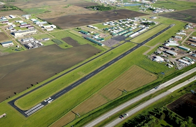
| Lat: N 4327.3 Long: W 09648.1 Elev: 1511 Var: -06 Longest Runway: 3650 | ||
| AWOS: 122.8 CTAF: 122.8 | ||
| ||||||||||||||||||||||||||||||||||||||||||||
| ||||||||||||||||||||||||||||||||||||||||||||
| ||||||||||||||||||||||||||||||||||||||||||||
| Rwy | Rwy | |||||||
| 3650x60 | 3650' | 3650x60 | 3650' | |||||
| Runway ID | Single Wheel | Double Wheel | Double Tandem Wheel | Dual Double Wheel |
| 16/34 | 22,000 | N/A | N/A | N/A |
| These numbers are Advisory and are not limits. The Airport Manager should have more accurate Weight Limits | ||||
| FltPlan does not have IFR approach charts available for KY14. |
| Facility Name: | MARV SKIE-LINCOLN COUNTY |
| City Name: | TEA |
| County: | LINCOLN |
| State abbrev: | SD |
| State Name: | SOUTH DAKOTA |
| Ownership: | PUBLICLY OWNED |
| Use: | OPEN TO THE PUBLIC |
| Owner's Name: | LINCOLN COUNTY |
| Address: | 100 EAST 5TH |
| CANTON, SD 57013 | |
| Owner's Phone: | 605-764-2581 |
| Manager's Name: | JORDAN HALL |
| Address: | 47010 GREAT PLANES PLACE |
| TEA, SD 57064 | |
| Phone: | 605-368-2841 |
| FAA Region: | GREAT LAKES |
| FAA Field Office: | DMA |
| Date | Sunrise | Sunset |
|---|---|---|
| 09/24/21 Friday | 7:16 | 19:21 |
| 09/25/21 Saturday | 7:18 | 19:19 |
| 09/26/21 Sunday | 7:19 | 19:18 |
| 09/27/21 Monday | 7:20 | 19:16 |
| 09/28/21 Tuesday | 7:21 | 19:14 |
| 09/29/21 Wednesday | 7:22 | 19:12 |
| 09/30/21 Thursday | 7:23 | 19:10 |
| 10/01/21 Friday | 7:24 | 19:09 |
| 10/02/21 Saturday | 7:26 | 19:07 |
| 10/03/21 Sunday | 7:27 | 19:05 |
| 10/04/21 Monday | 7:28 | 19:03 |
| 10/05/21 Tuesday | 7:29 | 19:02 |
| 10/06/21 Wednesday | 7:30 | 19:00 |
| 10/07/21 Thursday | 7:31 | 18:58 |
| Airport Attendance Schedule | 7 Days A Week 0800-DUSK |
| Airport Status | OPERATIONAL (This Status can change at any time - please check NOTAMS) |
| Airport Lighting Schedule | ACTVT MIRL RY 16/34 - CTAF. |
| Airport Storage Available | Tie Downs, Hanger |
| Extra Services Available | Avionics, Charter, Flight Instruction, Aircraft Rental |
| Wind Indicator | YES - (lighted) |
| Control Tower | NO |
| CTAF Frequency | 122.800 |
| Unicom Frequency | 122.800; AUTOMATED UNICOM. |
| Rotating Beacon Color | CLEAR-GREEN (Light Land Airport) |
| Segmented Circle | NO |
| Landing Fee | NO |
| Airport Inspected | STATE - performed by STATE AERONAUTICAL PERSONNEL |
| Inspection Date | 07/14/2021 |
| Type of Fuel Available | Grade 100LL, JET A (freeze point -40C); -10FUEL AVBL 24 HRS WITH CREDIT CARD.; -A FUEL AVBL 24 HRS WITH CREDIT CARD. |
| Airframe Repair Service | MAJOR |
| Power Plant Repair Service | MAJOR |
| Latitude | N4327.3 |
| Longitude | W09648.1 (ESTIMATED) |
| Arpt Elevation | 1511ft (SURVEYED) |
| Magnetic Variation | 06E |
| 2 miles NE | of TEA |
| Traffic Pattern Altitude | |
| Sectional Chart | OMAHA |
| Operations (Reported) | Yearly | Avg. Daily |
|---|---|---|
| General Aviation Transient | 2750 | 8 |
| General Aviation Local | 15400 | 42 |
| Air Taxi | 200 | 1 |
| Commerical | 0 | 0 |
| Commuter | 0 | 0 |
| Military | 0 | 0 |
| Aircraft based on Field | |
|---|---|
| General Aviation Singles | 59 |
| General Aviation Multi | 4 |
| Jet Aircraft | 0 |
| General Aviation Helicopters | 0 |
| Military Aircraft | 0 |
| Gliders | 0 |
| Ultralights | 0 |
| FSS on field | NO |
| FSS tie-in | HURON |
| FSS Phone | 1-800-WX-BRIEF |
| Who issues Notams | HON |
| Notam D service at airport | YES |
| ARTCC Name | MINNEAPOLIS |
| Airport Certification | |
| Aircraft Rescue & Firefighting Index | None |
| Airport of Entry | No |
| Custom Landing Rights | No |
| Joint Civil/Military | No |
| Military Landing rights | No |
| NATIONAL PLAN OF INTEGRATED AIRPORT SYSTEMS (NPIAS) |
| GRANT AGREEMENTS UNDER FAAP/ADAP/AIP |
| ASSURANCES PURSUANT TO TITLE VI, CIVIL RIGHTS ACT OF 1964 |
| ULTRALIGHTS ON & INVOF ARPT. |
| BE ALERT: ACFT ON APCH TO RY 03 AT JOE FOSS FIELD (FSD) DESCENDING/HOLDING AT 3300 FT OVER ROKKY LOM LCTD 2.4 MILES NNW OF THE ARPT. |
| HAY CUTTING OPERATIONS MAY-SEP; FARMING EQUIPMENT MAY BE IN APCH ZONES. |
| GCO AVBL ON FREQ 121.725 ( 4 CLICKS TO SIOUX FALLS TWR ) |
| FOR CD IF UNA VIA GCO CTC MINNEAPOLIS ARTCC AT 651-463-5588. |
| Runway: 16 | Runway: 34 | ||
| Mag heading: | N/A | Mag heading: | N/A |
| Rwy Slope: | -.60% Down | Rwy Slope: | .60% Up |
| Approach: | Approach: | ||
| Pattern: | Left Traffic | Pattern: | Left Traffic |
| Markings: | NONPRECISION INSTRUMENT | Markings: | NONPRECISION INSTRUMENT |
| Marking Condition: | GOOD | Marking Condition: | GOOD |
| Arresting Dev: | Arresting Dev: | ||
| Lat & Long: | N4327.6 W09648.2 | Lat. & Long.: | N4327.0 W09648.0 |
| Elev: | 1511.4 ft. MSL | Elev: | 1489.5 ft. MSL |
| TCH: | 42 ft. AGL | TCH: | 45 ft. AGL |
| Visual Glide Path: | 3.00 degrees | Visual Glide Path: | 3.00 degrees |
| Displaced Threshold: | No | Displaced Threshold: | No |
| Touchdown Zone: | YES | Touchdown Zone: | YES |
| Touchdown Elev.: | 1511.4 feet | Touchdown Elev.: | 1509.8 feet |
| Visual Glide Slope: | 2-Light PAPI on LEFT side of Runway | Visual Glide Slope: | 2-Light PAPI on LEFT side of Runway |
| RVR Equipment: | RVR Equipment: | ||
| RVV Equipment: | NO | RVV Equipment: | NO |
| Approach Lights: | Approach Lights: | ||
| REIL: | YES | REIL: | YES |
| Centerline Lights: | NO | Centerline Lights: | NO |
| Touchdown lights: | NO | Touchdown lights: | NO |
| Runway Category: | Runway with a Visual Approach | Runway Category: | Runway with a Visual Approach |
| Declared Distances: | Declared Distances: | ||
| Obstructions: | ROAD | Obstructions: | |
| Marked: | NOT Marked/Lighted | Marked: | |
| Clearance slope: | 27:1 | Clearance slope: | 50:1 |
| Obstruction height: | 10 feet AGL | Obstruction height: | |
| Dist. from runway: | 470 feet | Dist. from runway: | |
| Centerline offset: | Centerline offset: | ||
| Comments: | Comments: |
Thanks for using FltPlan.com
all rights reserved © 1999-2021 by Flight Plan LLC