
| SUGAR LOAF RESORT (CLOSED) TRAVERSE CITY MI |
| |
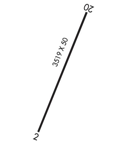
| Lat: N 4454.4 Long: W 08549.0 Elev: 825 Var: +04 Longest Runway: 3512 | ||
| CTAF: 122.9 | ||
| ||||||||||||||||||||||||||||||||
| ||||||||||||||||||||||||||||||||
| Rwy | Rwy | |||||||
| 3512x50 | 3512' | 3512x50 | 2940' | |||||
| Runway ID | Single Wheel | Double Wheel | Double Tandem Wheel | Dual Double Wheel |
| These numbers are Advisory and are not limits. The Airport Manager should have more accurate Weight Limits | ||||
| FltPlan does not have IFR approach charts available for KY04. |
 Airport Diagram might not be current. | |
| Facility Name: | SUGAR LOAF RESORT |
| City Name: | TRAVERSE CITY |
| County: | LEELANAU |
| State abbrev: | MI |
| State Name: | MICHIGAN |
| Ownership: | PRIVATELY OWNED |
| Use: | OPEN TO THE PUBLIC |
| Owner's Name: | SUGARLOAF ALL SEASON RESORT |
| Address: | 4500 S SUGAR LOAF MT RD |
| CEDAR, MI 49621 | |
| Owner's Phone: | 231-218-0488; WALLY FRYER-OWNER'S CONTACT |
| Manager's Name: | DANE HYDE |
| Address: | 4500 SUGARLOAF MTN. RD |
| CEDAR, MI 49621 | |
| Phone: | 231-228-5116 |
| FAA Region: | GREAT LAKES |
| FAA Field Office: | DET |
| Date | Sunrise | Sunset |
|---|---|---|
| 03/07/20 Saturday | 7:09 | 18:40 |
| 03/08/20 Sunday | 8:07 | 19:41 |
| 03/09/20 Monday | 8:05 | 19:43 |
| 03/10/20 Tuesday | 8:04 | 19:44 |
| 03/11/20 Wednesday | 8:02 | 19:45 |
| 03/12/20 Thursday | 8:00 | 19:47 |
| 03/13/20 Friday | 7:58 | 19:48 |
| 03/14/20 Saturday | 7:56 | 19:49 |
| 03/15/20 Sunday | 7:54 | 19:50 |
| 03/16/20 Monday | 7:53 | 19:52 |
| 03/17/20 Tuesday | 7:51 | 19:53 |
| 03/18/20 Wednesday | 7:49 | 19:54 |
| 03/19/20 Thursday | 7:47 | 19:56 |
| 03/20/20 Friday | 7:45 | 19:57 |
| Airport Attendance Schedule | UNATTENDED |
| Airport Status | OPERATIONAL (This Status can change at any time - please check NOTAMS) |
| Airport Lighting Schedule | |
| Airport Storage Available | Tie Downs |
| Extra Services Available | NONE |
| Wind Indicator | YES - (unlit) |
| Control Tower | NO |
| CTAF Frequency | 122.900 |
| Unicom Frequency | |
| Rotating Beacon Color | |
| Segmented Circle | NO |
| Landing Fee |
| Airport Inspected | STATE - performed by STATE AERONAUTICAL PERSONNEL |
| Inspection Date | 06/20/2012 |
| Type of Fuel Available | None |
| Airframe Repair Service | None |
| Power Plant Repair Service | None |
| Latitude | N4454.4 |
| Longitude | W08549.0 (ESTIMATED) |
| Arpt Elevation | 825ft (SURVEYED) |
| Magnetic Variation | 04W |
| 14 miles NW | of TRAVERSE CITY |
| Traffic Pattern Altitude | |
| Sectional Chart | GREEN BAY |
| Operations (Reported) | Yearly | Avg. Daily |
|---|---|---|
| General Aviation Transient | 50 | 0 |
| General Aviation Local | 50 | 0 |
| Air Taxi | 0 | 0 |
| Commerical | 0 | 0 |
| Commuter | 0 | 0 |
| Military | 0 | 0 |
| Aircraft based on Field | |
|---|---|
| General Aviation Singles | 0 |
| General Aviation Multi | 0 |
| Jet Aircraft | 0 |
| General Aviation Helicopters | 0 |
| Military Aircraft | 0 |
| Gliders | 0 |
| Ultralights | 0 |
| FSS on field | NO |
| FSS tie-in | LANSING |
| FSS Phone | 1-800-WX-BRIEF |
| Who issues Notams | LAN |
| Notam D service at airport | YES |
| ARTCC Name | MINNEAPOLIS |
| Airport Certification | |
| Aircraft Rescue & Firefighting Index | None |
| Airport of Entry | No |
| Custom Landing Rights | No |
| Joint Civil/Military | No |
| Military Landing rights | No |
| +10 FT HILL ON EACH SIDE OF RY; 10 FT FM PAVEMENT EDGES IN MIDSECTION OF RY |
| FOR CD CTC MINNEAPOLIS ARTCC AT 651-463-5588. |
| SKI HILL ADJACENT TO RY NW SIDE. |
| PEDESTRIANS & GOLF COURSE ADJACENT TO RY N END, PEDESTRIANS & EQUIPMENT CROSSING RWY. |
| ADJ SKI FACILITY CLSD. |
| DAY OPS ONLY. |
| NO SNOW REMOVAL. |
| RWY 02/2 0 EXTENSIVE PAVEMENT CRACKING. |
| RWY 02 1 RWY MARKING FADED. |
| Runway: 02 | Runway: 20 | ||
| Mag heading: | N/A | Mag heading: | N/A |
| Rwy Slope: | .00% | Rwy Slope: | .00% |
| Approach: | Approach: | ||
| Pattern: | Left Traffic | Pattern: | Left Traffic |
| Markings: | BASIC | Markings: | BASIC |
| Marking Condition: | POOR; RWY MARKINGS FADED. | Marking Condition: | POOR; RY MARKINGS FADED. |
| Arresting Dev: | Arresting Dev: | ||
| Lat & Long: | N4454.1 W08549.1 | Lat. & Long.: | N4454.6 W08548.8 |
| Elev: | 825.0 ft. MSL | Elev: | 825.0 ft. MSL |
| TCH: | TCH: | ||
| Visual Glide Path: | Visual Glide Path: | ||
| Displaced Threshold: | No | Displaced Threshold: | 572 feet |
| Touchdown Zone: | NO | Touchdown Zone: | NO |
| Touchdown Elev.: | Touchdown Elev.: | ||
| Visual Glide Slope: | Visual Glide Slope: | ||
| RVR Equipment: | RVR Equipment: | ||
| RVV Equipment: | NO | RVV Equipment: | NO |
| Approach Lights: | Approach Lights: | ||
| REIL: | NO | REIL: | NO |
| Centerline Lights: | NO | Centerline Lights: | NO |
| Touchdown lights: | NO | Touchdown lights: | NO |
| Runway Category: | Runway with a Visual Approach | Runway Category: | Runway with a Visual Approach |
| Declared Distances: | Declared Distances: | ||
| Obstructions: | TREES | Obstructions: | TREES |
| Marked: | NOT Marked/Lighted | Marked: | NOT Marked/Lighted |
| Clearance slope: | 12:1; 71 FT TREES, 1052 FT DSTC, APPROACH RATIO 12:1. | Clearance slope: | 9:1; RWY 20 APCH RATIO 23:1 AT DSPLCD THR. |
| Obstruction height: | 71 feet AGL | Obstruction height: | 59 feet AGL |
| Dist. from runway: | 1052 feet | Dist. from runway: | 731 feet |
| Centerline offset: | 75 right of centerline | Centerline offset: | 200 feet right of centerline |
| Comments: | 20 FT TREES 0-200 FT FM THLD 90 FT L/R. | Comments: | +3 FT ELECTRICAL BOX 90 FT FROM RWY END, 84 FT.L. |
Thanks for using FltPlan.com
all rights reserved © 1999-2020 by Flight Plan LLC
