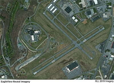
| ALLENTOWN QUEEN CITY MUNI ALLENTOWN PA |
| |
| Lat: N 4034.2 Long: W 07529.3 Elev: 399 Var: +12 Longest Runway: 3950 | ||
| Clr Del: 118.9 AWOS: 127.87 CTAF: 122.7 | ||
| |||||||||||||||||||||||||||||||||||||||||||||||||||||||||||||||||||||
| |||||||||||||||||||||||||||||||||||||||||||||||||||||||||||||||||||||
| |||||||||||||||||||||||||||||||||||||||||||||||||||||||||||||||||||||
| Rwy | Rwy | |||||||
| 3950x75 | 3950' | 3950x75 | 3950' | |||||
| 3160x75 | 3160' | 3160x75 | 3160' | |||||
| Runway ID | Single Wheel | Double Wheel | Double Tandem Wheel | Dual Double Wheel |
| 07/25 | 12,000 | N/A | N/A | N/A |
| 15/33 | 12,000 | N/A | N/A | N/A |
| These numbers are Advisory and are not limits. The Airport Manager should have more accurate Weight Limits | ||||
 Airport Diagram might not be current. | |
| Facility Name: | ALLENTOWN QUEEN CITY MUNI |
| City Name: | ALLENTOWN |
| County: | LEHIGH |
| State abbrev: | PA |
| State Name: | PENNSYLVANIA |
| Ownership: | PUBLICLY OWNED |
| Use: | OPEN TO THE PUBLIC |
| Owner's Name: | LEHIGH NORTHAM ARPT AUTH |
| Address: | 3311 AIRPORT RD |
| ALLENTOWN, PA 18109 | |
| Owner's Phone: | 610-266-6001 |
| Manager's Name: | THOMAS R. STOUDT |
| Address: | 1730 VULTEE STREET |
| ALLENTOWN, PA 18109 | |
| Phone: | 610-791-5193 |
| FAA Region: | EASTERN |
| FAA Field Office: | HAR |
| Date | Sunrise | Sunset |
|---|---|---|
| 09/24/21 Friday | 6:51 | 18:56 |
| 09/25/21 Saturday | 6:52 | 18:54 |
| 09/26/21 Sunday | 6:53 | 18:53 |
| 09/27/21 Monday | 6:54 | 18:51 |
| 09/28/21 Tuesday | 6:55 | 18:49 |
| 09/29/21 Wednesday | 6:56 | 18:48 |
| 09/30/21 Thursday | 6:57 | 18:46 |
| 10/01/21 Friday | 6:58 | 18:44 |
| 10/02/21 Saturday | 6:59 | 18:43 |
| 10/03/21 Sunday | 7:00 | 18:41 |
| 10/04/21 Monday | 7:01 | 18:40 |
| 10/05/21 Tuesday | 7:02 | 18:38 |
| 10/06/21 Wednesday | 7:03 | 18:36 |
| 10/07/21 Thursday | 7:04 | 18:35 |
| Airport Attendance Schedule | 7 Days A Week 0700-1800 |
| Airport Status | OPERATIONAL (This Status can change at any time - please check NOTAMS) |
| Airport Lighting Schedule | ACTVT MIRL RWY 07/25, 15/33 AND REIL RWY 07/25 - CTAF. |
| Airport Storage Available | Tie Downs, Hanger |
| Extra Services Available | Air Freight, Flight Instruction, Aircraft Rental |
| Wind Indicator | YES - (lighted) |
| Control Tower | NO |
| CTAF Frequency | 122.700 |
| Unicom Frequency | 122.700 |
| Rotating Beacon Color | CLEAR-GREEN (Light Land Airport) |
| Segmented Circle | NO |
| Landing Fee | NO |
| Airport Inspected | STATE - performed by STATE AERONAUTICAL PERSONNEL |
| Inspection Date | 03/24/2021 |
| Type of Fuel Available | Grade 100LL, JET A (freeze point -40C) |
| Airframe Repair Service | MINOR |
| Power Plant Repair Service | MINOR |
| Latitude | N4034.2 |
| Longitude | W07529.3 (ESTIMATED) |
| Arpt Elevation | 399ft (SURVEYED) |
| Magnetic Variation | 12W |
| 2 miles SW | of ALLENTOWN |
| Traffic Pattern Altitude | |
| Sectional Chart | NEW YORK |
| Operations (Reported) | Yearly | Avg. Daily |
|---|---|---|
| General Aviation Transient | 2400 | 7 |
| General Aviation Local | 20000 | 55 |
| Air Taxi | 500 | 1 |
| Commerical | 0 | 0 |
| Commuter | 0 | 0 |
| Military | 60 | 0 |
| Aircraft based on Field | |
|---|---|
| General Aviation Singles | 52 |
| General Aviation Multi | 12 |
| Jet Aircraft | 1 |
| General Aviation Helicopters | 3 |
| Military Aircraft | 0 |
| Gliders | 0 |
| Ultralights | 0 |
| FSS on field | NO |
| FSS tie-in | WILLIAMSPORT |
| FSS Phone | 1-800-WX-BRIEF |
| Who issues Notams | IPT |
| Notam D service at airport | YES |
| ARTCC Name | NEW YORK |
| Airport Certification | |
| Aircraft Rescue & Firefighting Index | None |
| Airport of Entry | No |
| Custom Landing Rights | No |
| Joint Civil/Military | No |
| Military Landing rights | YES |
| NATIONAL PLAN OF INTEGRATED AIRPORT SYSTEMS (NPIAS) |
| GRANT AGREEMENTS UNDER FAAP/ADAP/AIP |
| SURPLUS PROPERTY AGREEMENT UNDER REGULATION 16-WAA |
| ASSURANCES PURSUANT TO TITLE VI, CIVIL RIGHTS ACT OF 1964 |
| DEER, GROUNDHOGS AND BIRDS ON & INVOF ARPT. |
| NOISE ABATEMENT PROC IN EFCT, FOR DETAILS CTC ARPT MGR. |
| FOR SVC AFT HRS CTC 610-266-6000. |
| FOR CD CTC ALLENTOWN APCH AT 800-728-6322. |
Airport Communications & Frequencies:
| ||||||||||||||||||||
| Runway: 07 | Runway: 25 | ||
| Mag heading: | 70° | Mag heading: | 250° |
| Rwy Slope: | .04% Up | Rwy Slope: | -.04% Down |
| Approach: | Approach: | ||
| Pattern: | Left Traffic | Pattern: | Left Traffic |
| Markings: | NONPRECISION INSTRUMENT | Markings: | BASIC |
| Marking Condition: | GOOD | Marking Condition: | GOOD |
| Arresting Dev: | Arresting Dev: | ||
| Lat & Long: | N4034.0 W07529.7 | Lat. & Long.: | N4034.3 W07528.9 |
| Elev: | 386.4 ft. MSL | Elev: | 387.8 ft. MSL |
| TCH: | 41 ft. AGL | TCH: | 40 ft. AGL |
| Visual Glide Path: | 3.00 degrees | Visual Glide Path: | 3.50 degrees |
| Displaced Threshold: | No | Displaced Threshold: | No |
| Touchdown Zone: | YES | Touchdown Zone: | YES |
| Touchdown Elev.: | 390.3 feet | Touchdown Elev.: | 390.3 feet |
| Visual Glide Slope: | 4-Light PAPI on LEFT side of Runway | Visual Glide Slope: | 4-Light PAPI on LEFT side of Runway; UNUSBL BYD 3 DEG L OF COURSE. |
| RVR Equipment: | RVR Equipment: | ||
| RVV Equipment: | NO | RVV Equipment: | NO |
| Approach Lights: | Approach Lights: | ||
| REIL: | YES | REIL: | YES |
| Centerline Lights: | NO | Centerline Lights: | NO |
| Touchdown lights: | NO | Touchdown lights: | NO |
| Runway Category: | Runway with a Non-precision Approach | Runway Category: | Runway with a Visual Approach |
| Declared Distances: | Declared Distances: | ||
| Obstructions: | TREE | Obstructions: | POLE |
| Marked: | NOT Marked/Lighted | Marked: | LIGHTED |
| Clearance slope: | 16:1 | Clearance slope: | 19:1 |
| Obstruction height: | 60 feet AGL | Obstruction height: | 23 feet AGL |
| Dist. from runway: | 1164 feet | Dist. from runway: | 635 feet |
| Centerline offset: | 378 right of centerline | Centerline offset: | 112 feet left of centerline |
| Comments: | Comments: |
| Runway: 15 | Runway: 33 | ||
| Mag heading: | 147° | Mag heading: | 327° |
| Rwy Slope: | .41% Up | Rwy Slope: | -.41% Down |
| Approach: | Approach: | ||
| Pattern: | Left Traffic | Pattern: | Left Traffic |
| Markings: | BASIC | Markings: | BASIC |
| Marking Condition: | GOOD | Marking Condition: | GOOD |
| Arresting Dev: | Arresting Dev: | ||
| Lat & Long: | N4034.5 W07529.5 | Lat. & Long.: | N4034.1 W07529.1 |
| Elev: | 386.1 ft. MSL | Elev: | 399.0 ft. MSL |
| TCH: | TCH: | ||
| Visual Glide Path: | Visual Glide Path: | ||
| Displaced Threshold: | No | Displaced Threshold: | No |
| Touchdown Zone: | YES | Touchdown Zone: | YES |
| Touchdown Elev.: | 398.6 feet | Touchdown Elev.: | 399.0 feet |
| Visual Glide Slope: | Visual Glide Slope: | ||
| RVR Equipment: | RVR Equipment: | ||
| RVV Equipment: | NO | RVV Equipment: | NO |
| Approach Lights: | Approach Lights: | ||
| REIL: | NO | REIL: | NO |
| Centerline Lights: | NO | Centerline Lights: | NO |
| Touchdown lights: | NO | Touchdown lights: | NO |
| Runway Category: | Runway with a Visual Approach | Runway Category: | Runway with a Visual Approach |
| Declared Distances: | Declared Distances: | ||
| Obstructions: | TREE | Obstructions: | |
| Marked: | NOT Marked/Lighted | Marked: | |
| Clearance slope: | 6:1 | Clearance slope: | 20:1 |
| Obstruction height: | 28 feet AGL | Obstruction height: | |
| Dist. from runway: | 392 feet | Dist. from runway: | |
| Centerline offset: | 27 right of centerline | Centerline offset: | |
| Comments: | Comments: |
Thanks for using FltPlan.com
all rights reserved © 1999-2021 by Flight Plan LLC