
| WILLISTON MUNI WILLISTON FL |
| |
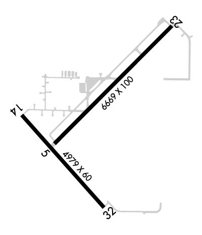
| Lat: N 2921.3 Long: W 08228.2 Elev: 76 Var: +04 Longest Runway: 6669 | ||
| AWOS: 118.42 CTAF: 122.97 | ||
| ||||||||||||||||||||||||||||||||||||||||||||
| ||||||||||||||||||||||||||||||||||||||||||||
| ||||||||||||||||||||||||||||||||||||||||||||
| Rwy | Rwy | |||||||
| 6669x100 | 6669' | 6669x100 | 6669' | |||||
| 4979x60 | 4979' | 4979x60 | 4979' | |||||
| 2051x60 | 2051' | 2051x60 | 2051' | |||||
| Runway ID | Single Wheel | Double Wheel | Double Tandem Wheel | Dual Double Wheel |
| 05/23 | 72,000 | 95,000 | 160,000 | N/A |
| 14/32 | 38,000 | N/A | N/A | N/A |
| 18/36 | N/A | N/A | N/A | N/A |
| These numbers are Advisory and are not limits. The Airport Manager should have more accurate Weight Limits | ||||
 Airport Diagram might not be current. | |
| Facility Name: | WILLISTON RGNL |
| City Name: | WILLISTON |
| County: | LEVY |
| State abbrev: | FL |
| State Name: | FLORIDA |
| Ownership: | PUBLICLY OWNED |
| Use: | OPEN TO THE PUBLIC |
| Owner's Name: | CITY OF WILLISTON |
| Address: | PO BOX 160 |
| WILLISTON, FL 32696 | |
| Owner's Phone: | 352-256-7136 |
| Manager's Name: | BENTON STEGALL |
| Address: | 1891 SW 18TH ST |
| WILLISTON, FL 32696-0160 | |
| Phone: | 352-266-5792 |
| FAA Region: | SOUTHERN |
| FAA Field Office: | ORL |
| Date | Sunrise | Sunset |
|---|---|---|
| 06/08/26 Monday | 6:30 | 20:28 |
| 06/09/26 Tuesday | 6:30 | 20:29 |
| 06/10/26 Wednesday | 6:30 | 20:29 |
| 06/11/26 Thursday | 6:30 | 20:29 |
| 06/12/26 Friday | 6:30 | 20:30 |
| 06/13/26 Saturday | 6:30 | 20:30 |
| 06/14/26 Sunday | 6:30 | 20:30 |
| 06/15/26 Monday | 6:30 | 20:31 |
| 06/16/26 Tuesday | 6:30 | 20:31 |
| 06/17/26 Wednesday | 6:30 | 20:31 |
| 06/18/26 Thursday | 6:30 | 20:32 |
| 06/19/26 Friday | 6:30 | 20:32 |
| 06/20/26 Saturday | 6:31 | 20:32 |
| 06/21/26 Sunday | 6:31 | 20:32 |
| Airport Attendance Schedule | 7 Days A Week 0730-1730 |
| Airport Status | OPERATIONAL (This Status can change at any time - please check NOTAMS) |
| Airport Lighting Schedule | ACTVT REIL RWY 05, 14, 23 & 32; HIRL RWY 05/23; MIRL RWY 14/32. - CTAF. |
| Airport Storage Available | Tie Downs, Hanger |
| Extra Services Available | Charter, Flight Instruction, Aircraft Rental, Aircraft Sales |
| Wind Indicator | YES - (lighted) |
| Control Tower | NO |
| CTAF Frequency | 122.975 |
| Unicom Frequency | 122.975 |
| Rotating Beacon Color | WG |
| Segmented Circle | YES |
| Landing Fee | NO |
| Airport Inspected | STATE - performed by STATE AERONAUTICAL PERSONNEL |
| Inspection Date | 09/16/2025 |
| Type of Fuel Available | Grade 100LL, JET A (freeze point -40C) |
| Airframe Repair Service | MAJOR |
| Power Plant Repair Service | MAJOR |
| Latitude | N2921.3 |
| Longitude | W08228.2 (ESTIMATED) |
| Arpt Elevation | 75ft (SURVEYED) |
| Magnetic Variation | 04W |
| 2 miles SW | of WILLISTON |
| Traffic Pattern Altitude | |
| Sectional Chart | JACKSONVILLE |
| Operations (Reported) | Yearly | Avg. Daily |
|---|---|---|
| General Aviation Transient | 0 | 0 |
| General Aviation Local | 0 | 0 |
| Air Taxi | 0 | 0 |
| Commerical | 0 | 0 |
| Commuter | 0 | 0 |
| Military | 0 | 0 |
| Aircraft based on Field | |
|---|---|
| General Aviation Singles | 0 |
| General Aviation Multi | 0 |
| Jet Aircraft | 0 |
| General Aviation Helicopters | 0 |
| Military Aircraft | 0 |
| Gliders | 0 |
| Ultralights | 0 |
| FSS on field | NO |
| FSS tie-in | GAINESVILLE |
| FSS Phone | 1-800-WX-BRIEF |
| Who issues Notams | GNV |
| Notam D service at airport | YES |
| ARTCC Name | JACKSONVILLE |
| Airport Certification | |
| Aircraft Rescue & Firefighting Index | None |
| Airport of Entry | No |
| Custom Landing Rights | No |
| Joint Civil/Military | No |
| Military Landing rights | YES |
| NATIONAL PLAN OF INTEGRATED AIRPORT SYSTEMS (NPIAS) |
| GRANT AGREEMENTS UNDER FAAP/ADAP/AIP |
| SURPLUS PROPERTY AGREEMENT UNDER PUBLIC LAW 289 |
| SURPLUS PROPERTY AGREEMENT UNDER REGULATION 16-WAA |
| ASSURANCES PURSUANT TO TITLE VI, CIVIL RIGHTS ACT OF 1964 |
| INFIELD BERM & TREES BLOCKING VISION BTN RWY ENDS. |
| FOR CD CTC JACKSONVILLE APCH AT 904-741-0284. |
Airport Communications & Frequencies:
| ||||||||||||||
| Runway: 05 | Runway: 23 | ||
| Mag heading: | 49° | Mag heading: | 229° |
| Rwy Slope: | .04% Up | Rwy Slope: | -.04% Down |
| Approach: | Approach: | ||
| Pattern: | Left Traffic | Pattern: | Left Traffic |
| Markings: | NONPRECISION INSTRUMENT | Markings: | NONPRECISION INSTRUMENT |
| Marking Condition: | GOOD | Marking Condition: | GOOD |
| Arresting Dev: | Arresting Dev: | ||
| Lat & Long: | N2921.2 W08228.6 | Lat. & Long.: | N2921.9 W08227.7 |
| Elev: | 73.0 ft. MSL | Elev: | 75.6 ft. MSL |
| TCH: | 38 ft. AGL | TCH: | 35 ft. AGL |
| Visual Glide Path: | 3.00 degrees | Visual Glide Path: | 3.00 degrees |
| Displaced Threshold: | No | Displaced Threshold: | No |
| Touchdown Zone: | YES | Touchdown Zone: | YES |
| Touchdown Elev.: | 73.0 feet | Touchdown Elev.: | 75.6 feet |
| Visual Glide Slope: | 2-Light PAPI on LEFT side of Runway | Visual Glide Slope: | 2-Light PAPI on LEFT side of Runway |
| RVR Equipment: | RVR Equipment: | ||
| RVV Equipment: | NO | RVV Equipment: | NO |
| Approach Lights: | Approach Lights: | ||
| REIL: | YES | REIL: | YES |
| Centerline Lights: | NO | Centerline Lights: | NO |
| Touchdown lights: | NO | Touchdown lights: | NO |
| Runway Category: | Runway with a Non-precision Approach having visibility minimums greater than 3/4 mile | Runway Category: | Runway with a Non-precision Approach having visibility minimums greater than 3/4 mile |
| Declared Distances: | Declared Distances: | ||
| Obstructions: | TREES | Obstructions: | TREES |
| Marked: | NOT Marked/Lighted | Marked: | NOT Marked/Lighted |
| Clearance slope: | 34:1 | Clearance slope: | 35:1 |
| Obstruction height: | 46 feet AGL | Obstruction height: | 48 feet AGL |
| Dist. from runway: | 1785 feet | Dist. from runway: | 1920 feet |
| Centerline offset: | 180 left of centerline | Centerline offset: | 240 feet right of centerline |
| Comments: | Comments: |
| Runway: 14 | Runway: 32 | ||
| Mag heading: | 142° | Mag heading: | 322° |
| Rwy Slope: | -.06% Down | Rwy Slope: | .06% Up |
| Approach: | Approach: | ||
| Pattern: | Left Traffic | Pattern: | Left Traffic |
| Markings: | BASIC | Markings: | BASIC |
| Marking Condition: | FAIR | Marking Condition: | FAIR |
| Arresting Dev: | Arresting Dev: | ||
| Lat & Long: | N2921.3 W08228.8 | Lat. & Long.: | N2920.7 W08228.2 |
| Elev: | 66.8 ft. MSL | Elev: | 64.0 ft. MSL |
| TCH: | 42 ft. AGL | TCH: | 44 ft. AGL |
| Visual Glide Path: | 3.00 degrees | Visual Glide Path: | 3.00 degrees |
| Displaced Threshold: | No | Displaced Threshold: | No |
| Touchdown Zone: | YES | Touchdown Zone: | YES |
| Touchdown Elev.: | 74.0 feet | Touchdown Elev.: | 72.9 feet |
| Visual Glide Slope: | 2-Light PAPI on LEFT side of Runway | Visual Glide Slope: | 2-Light PAPI on LEFT side of Runway |
| RVR Equipment: | RVR Equipment: | ||
| RVV Equipment: | NO | RVV Equipment: | NO |
| Approach Lights: | Approach Lights: | ||
| REIL: | YES | REIL: | YES |
| Centerline Lights: | NO | Centerline Lights: | NO |
| Touchdown lights: | NO | Touchdown lights: | NO |
| Runway Category: | Runway with a Visual Approach | Runway Category: | Runway with a Visual Approach |
| Declared Distances: | Declared Distances: | ||
| Obstructions: | TREES | Obstructions: | TREES |
| Marked: | NOT Marked/Lighted | Marked: | NOT Marked/Lighted |
| Clearance slope: | 20:1 | Clearance slope: | 16:1 |
| Obstruction height: | 81 feet AGL | Obstruction height: | 50 feet AGL |
| Dist. from runway: | 1885 feet | Dist. from runway: | 1005 feet |
| Centerline offset: | 120 right of centerline | Centerline offset: | 125 feet left of centerline |
| Comments: | Comments: |
| Runway: 18 | Runway: 36 | ||
| Mag heading: | 184° | Mag heading: | 4° |
| Rwy Slope: | .05% Up | Rwy Slope: | -.05% Down |
| Approach: | Approach: | ||
| Pattern: | Right Traffic | Pattern: | Left Traffic |
| Markings: | NONE | Markings: | NONE |
| Marking Condition: | FAIR; RWY 18/36 MARKED WITH W TIRES. | Marking Condition: | FAIR |
| Arresting Dev: | Arresting Dev: | ||
| Lat & Long: | N2921.2 W08227.8 | Lat. & Long.: | N2920.8 W08227.8 |
| Elev: | 65.0 ft. MSL | Elev: | 66.0 ft. MSL |
| TCH: | TCH: | ||
| Visual Glide Path: | Visual Glide Path: | ||
| Displaced Threshold: | No | Displaced Threshold: | No |
| Touchdown Zone: | YES | Touchdown Zone: | YES |
| Touchdown Elev.: | 66.0 feet | Touchdown Elev.: | 66.0 feet |
| Visual Glide Slope: | Visual Glide Slope: | ||
| RVR Equipment: | RVR Equipment: | ||
| RVV Equipment: | NO | RVV Equipment: | NO |
| Approach Lights: | Approach Lights: | ||
| REIL: | NO | REIL: | NO |
| Centerline Lights: | NO | Centerline Lights: | NO |
| Touchdown lights: | NO | Touchdown lights: | NO |
| Runway Category: | Runway with a Visual Approach | Runway Category: | Runway with a Visual Approach |
| Declared Distances: | Declared Distances: | ||
| Obstructions: | TREES | Obstructions: | TREES |
| Marked: | NOT Marked/Lighted | Marked: | NOT Marked/Lighted |
| Clearance slope: | 34:1 | Clearance slope: | 22:1 |
| Obstruction height: | 88 feet AGL | Obstruction height: | 66 feet AGL |
| Dist. from runway: | 3050 feet | Dist. from runway: | 1505 feet |
| Centerline offset: | 125 right of centerline | Centerline offset: | 145 feet left of centerline |
| Comments: | Comments: |
Thanks for using FltPlan.com
all rights reserved © 1999-2026 by Flight Plan LLC
