| MIAMI HOMESTEAD GENERAL AVIATI HOMESTEAD FL |
| |
| Lat: N 2530.0 Long: W 08033.3 Elev: 7 Var: +06 Longest Runway: 4001 | ||
| AWOS: 118.37 CTAF: 122.8 | ||
| |||||||||||||||||||||||||||||||
| |||||||||||||||||||||||||||||||
| Rwy | Rwy | |||||||
| 2500x150 | 2500' | 2500x150 | 2500' | |||||
| 3000x75 | 3000' | 3000x75 | 3000' | |||||
| 4001x100 | 4001' | 4001x100 | 4001' | |||||
| Runway ID | Single Wheel | Double Wheel | Double Tandem Wheel | Dual Double Wheel |
| 09U/27U | N/A | N/A | N/A | N/A |
| 10/28 | 20,000 | N/A | N/A | N/A |
| 18/36 | 40,000 | 65,000 | 110,000 | N/A |
| These numbers are Advisory and are not limits. The Airport Manager should have more accurate Weight Limits | ||||
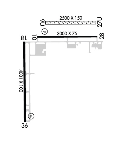 Airport Diagram might not be current. | |
| Facility Name: | MIAMI HOMESTEAD GENERAL AVIATION |
| City Name: | HOMESTEAD |
| County: | DADE |
| State abbrev: | FL |
| State Name: | FLORIDA |
| Ownership: | PUBLICLY OWNED |
| Use: | OPEN TO THE PUBLIC |
| Owner's Name: | MIAMI-DADE COUNTY; CONTACT PERSON: LIONEL BECKLES |
| Address: | MIAMI-DADE AVIATION DEPARTMENT, P.O. BOX 025504 |
| MIAMI, FL 33102-5504 | |
| Owner's Phone: | 305-876-7038 |
| Manager's Name: | JOSEPH KINNEBREW |
| Address: | 12800 SOUTHWEST 145TH AVENUE |
| MIAMI, FL 33186 | |
| Phone: | 305-876-7484 |
| FAA Region: | SOUTHERN |
| FAA Field Office: | ORL |
| Date | Sunrise | Sunset |
|---|---|---|
| 06/08/26 Monday | 6:31 | 20:12 |
| 06/09/26 Tuesday | 6:31 | 20:12 |
| 06/10/26 Wednesday | 6:31 | 20:13 |
| 06/11/26 Thursday | 6:31 | 20:13 |
| 06/12/26 Friday | 6:31 | 20:13 |
| 06/13/26 Saturday | 6:31 | 20:14 |
| 06/14/26 Sunday | 6:31 | 20:14 |
| 06/15/26 Monday | 6:31 | 20:14 |
| 06/16/26 Tuesday | 6:31 | 20:15 |
| 06/17/26 Wednesday | 6:31 | 20:15 |
| 06/18/26 Thursday | 6:31 | 20:15 |
| 06/19/26 Friday | 6:32 | 20:15 |
| 06/20/26 Saturday | 6:32 | 20:16 |
| 06/21/26 Sunday | 6:32 | 20:16 |
| Airport Attendance Schedule | CONTINUOUS |
| Airport Status | OPERATIONAL (This Status can change at any time - please check NOTAMS) |
| Airport Lighting Schedule | SS-SR |
| Airport Storage Available | Tie Downs, Hanger |
| Extra Services Available | Charter, Glider, Flight Instruction, Parachute Jumping, Aircraft Rental, Aircraft Sales, Annual Surveying, Glider Towing |
| Wind Indicator | YES - (lighted) |
| Control Tower | NO |
| CTAF Frequency | 122.800 |
| Unicom Frequency | 122.800 |
| Rotating Beacon Color | WG |
| Segmented Circle | Y-L |
| Landing Fee | NO |
| Airport Inspected | STATE - performed by STATE AERONAUTICAL PERSONNEL |
| Inspection Date | 05/13/2025 |
| Type of Fuel Available | Grade 100LL, JET A (freeze point -40C) |
| Airframe Repair Service | MAJOR |
| Power Plant Repair Service | MAJOR |
| Latitude | N2530.0 |
| Longitude | W08033.3 (ESTIMATED) |
| Arpt Elevation | 7ft (SURVEYED) |
| Magnetic Variation | 06W |
| 4 miles NW | of HOMESTEAD |
| Traffic Pattern Altitude | |
| Sectional Chart | MIAMI |
| Operations (Reported) | Yearly | Avg. Daily |
|---|---|---|
| General Aviation Transient | 0 | 0 |
| General Aviation Local | 0 | 0 |
| Air Taxi | 0 | 0 |
| Commerical | 0 | 0 |
| Commuter | 0 | 0 |
| Military | 0 | 0 |
| Aircraft based on Field | |
|---|---|
| General Aviation Singles | 0 |
| General Aviation Multi | 0 |
| Jet Aircraft | 0 |
| General Aviation Helicopters | 0 |
| Military Aircraft | 0 |
| Gliders | 0 |
| Ultralights | 0 |
| FSS on field | NO |
| FSS tie-in | MIAMI |
| FSS Phone | 1-800-WX-BRIEF |
| Who issues Notams | MIA |
| Notam D service at airport | YES |
| ARTCC Name | MIAMI |
| Airport Certification | |
| Aircraft Rescue & Firefighting Index | None |
| Airport of Entry | No |
| Custom Landing Rights | No |
| Joint Civil/Military | No |
| Military Landing rights | YES |
| NATIONAL PLAN OF INTEGRATED AIRPORT SYSTEMS (NPIAS) |
| GRANT AGREEMENTS UNDER FAAP/ADAP/AIP |
| ASSURANCES PURSUANT TO TITLE VI, CIVIL RIGHTS ACT OF 1964 |
| PAJA SE CORNER OF ARPT . |
| 24 HR PPR FOR ACFT EQUIPPED WITH WEATHER MODIFICATION OR GEOENGINEERING EQPT 305-247-4883 |
| AEROBATIC BOX S OF ARPT & E OF RWY 18/36. |
| REMOTE CTL MODEL FLYING FLDS 1.8 NM N RWY 18. |
| GLIDER ACT 8000 FT & BLW & CROP DUSTING INVOF ARPT. |
| FOR CD CTC MIAMI APCH AT 305-869-5432. |
Airport Communications & Frequencies:
| ||||||||||||||
| Runway: 09U | Runway: 27U | ||
| Mag heading: | N/A | Mag heading: | N/A |
| Approach: | Approach: | ||
| Pattern: | Left Traffic | Pattern: | Left Traffic |
| Markings: | NONSTANDARD | Markings: | NONSTANDARD |
| Marking Condition: | FAIR; MKD WITH WHITE CONES. | Marking Condition: | FAIR; MKD WITH WHITE CONES. |
| Arresting Dev: | Arresting Dev: | ||
| Lat & Long: | Lat. & Long.: | ||
| Elev: | N/A | Elev: | N/A |
| TCH: | TCH: | ||
| Visual Glide Path: | Visual Glide Path: | ||
| Displaced Threshold: | No | Displaced Threshold: | No |
| Touchdown Zone: | NO | Touchdown Zone: | NO |
| Touchdown Elev.: | Touchdown Elev.: | ||
| Visual Glide Slope: | Visual Glide Slope: | ||
| RVR Equipment: | RVR Equipment: | ||
| RVV Equipment: | NO | RVV Equipment: | NO |
| Approach Lights: | Approach Lights: | ||
| REIL: | NO | REIL: | NO |
| Centerline Lights: | NO | Centerline Lights: | NO |
| Touchdown lights: | NO | Touchdown lights: | NO |
| Runway Category: | Runway with a Visual Approach | Runway Category: | Runway with a Visual Approach |
| Declared Distances: | Declared Distances: | ||
| Obstructions: | TREES | Obstructions: | |
| Marked: | NOT Marked/Lighted | Marked: | |
| Clearance slope: | 50:1 | Clearance slope: | 50:1 |
| Obstruction height: | 46 feet AGL | Obstruction height: | |
| Dist. from runway: | 2270 feet | Dist. from runway: | |
| Centerline offset: | 40 left of centerline | Centerline offset: | |
| Comments: | Comments: |
| Runway: 10 | Runway: 28 | ||
| Mag heading: | 96° | Mag heading: | 276° |
| Rwy Slope: | .03% Up | Rwy Slope: | -.03% Down |
| Approach: | Approach: | ||
| Pattern: | Left Traffic | Pattern: | Right Traffic |
| Markings: | NONPRECISION INSTRUMENT | Markings: | NONPRECISION INSTRUMENT |
| Marking Condition: | GOOD | Marking Condition: | GOOD |
| Arresting Dev: | Arresting Dev: | ||
| Lat & Long: | N2530.2 W08033.3 | Lat. & Long.: | N2530.2 W08032.8 |
| Elev: | 6.0 ft. MSL | Elev: | 6.9 ft. MSL |
| TCH: | 71 ft. AGL | TCH: | |
| Visual Glide Path: | 3.00 degrees | Visual Glide Path: | |
| Displaced Threshold: | No | Displaced Threshold: | No |
| Touchdown Zone: | YES | Touchdown Zone: | YES |
| Touchdown Elev.: | 6.9 feet | Touchdown Elev.: | 6.9 feet |
| Visual Glide Slope: | 2-Light PAPI on LEFT side of Runway | Visual Glide Slope: | |
| RVR Equipment: | RVR Equipment: | ||
| RVV Equipment: | NO | RVV Equipment: | NO |
| Approach Lights: | Approach Lights: | ||
| REIL: | NO | REIL: | NO |
| Centerline Lights: | NO | Centerline Lights: | NO |
| Touchdown lights: | NO | Touchdown lights: | NO |
| Runway Category: | Runway with a Non-precision Approach | Runway Category: | Runway with a Non-precision Approach |
| Declared Distances: | Declared Distances: | ||
| Obstructions: | TREE | Obstructions: | |
| Marked: | NOT Marked/Lighted | Marked: | |
| Clearance slope: | 50:1 | Clearance slope: | 50:1 |
| Obstruction height: | 22 feet AGL | Obstruction height: | |
| Dist. from runway: | 1270 feet | Dist. from runway: | |
| Centerline offset: | 225 right of centerline | Centerline offset: | |
| Comments: | Comments: |
| Runway: 18 | Runway: 36 | ||
| Mag heading: | 185° | Mag heading: | 5° |
| Rwy Slope: | .00% Up | Rwy Slope: | .00% Down |
| Approach: | Approach: | ||
| Pattern: | Right Traffic | Pattern: | Left Traffic |
| Markings: | BASIC | Markings: | BASIC |
| Marking Condition: | FAIR | Marking Condition: | FAIR |
| Arresting Dev: | Arresting Dev: | ||
| Lat & Long: | N2530.1 W08033.4 | Lat. & Long.: | N2529.5 W08033.4 |
| Elev: | 6.9 ft. MSL | Elev: | 7.0 ft. MSL |
| TCH: | TCH: | 24 ft. AGL | |
| Visual Glide Path: | Visual Glide Path: | 3.00 degrees | |
| Displaced Threshold: | No | Displaced Threshold: | No |
| Touchdown Zone: | YES | Touchdown Zone: | YES |
| Touchdown Elev.: | 6.9 feet | Touchdown Elev.: | 7.0 feet |
| Visual Glide Slope: | Visual Glide Slope: | 4-Light PAPI on RIGHT side of Runway | |
| RVR Equipment: | RVR Equipment: | ||
| RVV Equipment: | NO | RVV Equipment: | NO |
| Approach Lights: | Approach Lights: | ||
| REIL: | NO | REIL: | NO |
| Centerline Lights: | NO | Centerline Lights: | NO |
| Touchdown lights: | NO | Touchdown lights: | NO |
| Runway Category: | Runway with a Visual Approach | Runway Category: | Runway with a Visual Approach |
| Declared Distances: | Declared Distances: |
Thanks for using FltPlan.com
all rights reserved © 1999-2026 by Flight Plan LLC