
| ARTHUR DUNN AIR PARK TITUSVILLE FL |
| |
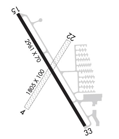
| Lat: N 2837.4 Long: W 08050.1 Elev: 30 Var: +05 Longest Runway: 2961 | ||
| AWOS: 119.72 CTAF: 123.0 | ||
| ||||||
|
| Rwy | Rwy | |||||||
| 1805x100 | 1705' | 1805x100 | 1508' | |||||
| 2961x70 | 2961' | 2961x70 | 2532' | |||||
| Runway ID | Single Wheel | Double Wheel | Double Tandem Wheel | Dual Double Wheel |
| 04/22 | N/A | N/A | N/A | N/A |
| 15/33 | 12,000 | N/A | N/A | N/A |
| These numbers are Advisory and are not limits. The Airport Manager should have more accurate Weight Limits | ||||
 Airport Diagram might not be current. | |
| Facility Name: | ARTHUR DUNN AIR PARK |
| City Name: | TITUSVILLE |
| County: | BREVARD |
| State abbrev: | FL |
| State Name: | FLORIDA |
| Ownership: | PUBLICLY OWNED |
| Use: | OPEN TO THE PUBLIC |
| Owner's Name: | TITUSVILLE -COCOA AIRPORT DISTRICT; CONTACT PERSON: MICHAEL POWELL C.M., ACE 321-267-8780 |
| Address: | 355 GOLDEN KNIGHTS BLVD |
| TITUSVILLE, FL 32780 | |
| Owner's Phone: | 321-267-8780 |
| Manager's Name: | MICHAEL D POWELL C.M., ACE; FAX 321-383-4284 |
| Address: | 355 GOLDEN KNIGHTS BLVD. |
| TITUSVILLE, FL 32780 | |
| Phone: | 321-267-8780 |
| FAA Region: | SOUTHERN |
| FAA Field Office: | ORL |
| Date | Sunrise | Sunset |
|---|---|---|
| 09/24/21 Friday | 7:13 | 19:18 |
| 09/25/21 Saturday | 7:13 | 19:17 |
| 09/26/21 Sunday | 7:14 | 19:15 |
| 09/27/21 Monday | 7:14 | 19:14 |
| 09/28/21 Tuesday | 7:15 | 19:13 |
| 09/29/21 Wednesday | 7:15 | 19:12 |
| 09/30/21 Thursday | 7:16 | 19:11 |
| 10/01/21 Friday | 7:16 | 19:09 |
| 10/02/21 Saturday | 7:17 | 19:08 |
| 10/03/21 Sunday | 7:17 | 19:07 |
| 10/04/21 Monday | 7:18 | 19:06 |
| 10/05/21 Tuesday | 7:18 | 19:05 |
| 10/06/21 Wednesday | 7:19 | 19:04 |
| 10/07/21 Thursday | 7:19 | 19:03 |
| Airport Attendance Schedule | 7 Days A Week 0800-2000 |
| Airport Status | OPERATIONAL (This Status can change at any time - please check NOTAMS) |
| Airport Lighting Schedule | ACTVT MIRL RY 15/33 - CTAF. |
| Airport Storage Available | Tie Downs, Hanger |
| Extra Services Available | Parachute Jumping |
| Wind Indicator | YES - (lighted) |
| Control Tower | NO |
| CTAF Frequency | 123.000 |
| Unicom Frequency | 123.000 |
| Rotating Beacon Color | CLEAR-GREEN (Light Land Airport); ARPT BCN OTS INDEFLY. |
| Segmented Circle | Y-L |
| Landing Fee | NO |
| Airport Inspected | STATE - performed by STATE AERONAUTICAL PERSONNEL |
| Inspection Date | 08/15/2018 |
| Type of Fuel Available | Grade 100LL, JET A (freeze point -40C) |
| Airframe Repair Service | MAJOR |
| Power Plant Repair Service | MAJOR |
| Latitude | N2837.4 |
| Longitude | W08050.1 (ESTIMATED) |
| Arpt Elevation | 30ft (SURVEYED) |
| Magnetic Variation | 05W |
| 2 miles NW | of TITUSVILLE |
| Traffic Pattern Altitude | 800; TPA FOR ULTRALIGHT ACFT 500 FT. |
| Sectional Chart | JACKSONVILLE |
| Operations (Reported) | Yearly | Avg. Daily |
|---|---|---|
| General Aviation Transient | 10000 | 27 |
| General Aviation Local | 30000 | 82 |
| Air Taxi | 0 | 0 |
| Commerical | 0 | 0 |
| Commuter | 0 | 0 |
| Military | 450 | 1 |
| Aircraft based on Field | |
|---|---|
| General Aviation Singles | 17 |
| General Aviation Multi | 2 |
| Jet Aircraft | 0 |
| General Aviation Helicopters | 0 |
| Military Aircraft | 0 |
| Gliders | 0 |
| Ultralights | 1 |
| FSS on field | NO |
| FSS tie-in | SAINT PETERSBURG |
| FSS Phone | 1-800-WX-BRIEF |
| Who issues Notams | PIE |
| Notam D service at airport | YES |
| ARTCC Name | MIAMI |
| Airport Certification | |
| Aircraft Rescue & Firefighting Index | None |
| Airport of Entry | No |
| Custom Landing Rights | No |
| Joint Civil/Military | No |
| Military Landing rights | YES |
| NATIONAL PLAN OF INTEGRATED AIRPORT SYSTEMS (NPIAS) |
| GRANT AGREEMENTS UNDER FAAP/ADAP/AIP |
| ASSURANCES PURSUANT TO TITLE VI, CIVIL RIGHTS ACT OF 1964 |
| EXTENSIVE ULTRALIGHT ACTIVITY INVOF ARPT. |
| SVRL RADIO TOWERS 1.5 NM SOUTH OF FIELD; THE TALLEST TOWER IS 399 FT AGL. |
| FOR INFO ON RY USE CALL ARPT AUTHORITY 321-267-8780. |
| FOR CD OR TO CNL IFR CTC ORLANDO APCH AT 407-825-3398. |
| RWY 04/2 2 RY 04/22 RESTRICTED TO ULTRALIGHT AND STOL ACFT ONLY. |
Airport Communications & Frequencies:
| ||||||||||||||||||||||
| Runway: 04 | Runway: 22 | ||
| Mag heading: | 37° | Mag heading: | 217° |
| Rwy Slope: | -.13% Down | Rwy Slope: | .13% Up |
| Approach: | Approach: | ||
| Pattern: | Left Traffic | Pattern: | Left Traffic |
| Markings: | NONSTANDARD | Markings: | NONSTANDARD |
| Marking Condition: | GOOD; RWY 04/22 MKD WITH W CONES. | Marking Condition: | GOOD; RWY 04/22 MKD WITH W CONES. |
| Arresting Dev: | Arresting Dev: | ||
| Lat & Long: | N2837.2 W08050.2 | Lat. & Long.: | N2837.5 W08050.0 |
| Elev: | 27.5 ft. MSL | Elev: | 25.2 ft. MSL |
| TCH: | TCH: | ||
| Visual Glide Path: | Visual Glide Path: | ||
| Displaced Threshold: | 100 feet | Displaced Threshold: | 297 feet |
| Touchdown Zone: | YES | Touchdown Zone: | YES |
| Touchdown Elev.: | 27.5 feet | Touchdown Elev.: | 25.2 feet |
| Visual Glide Slope: | Visual Glide Slope: | ||
| RVR Equipment: | RVR Equipment: | ||
| RVV Equipment: | NO | RVV Equipment: | NO |
| Approach Lights: | Approach Lights: | ||
| REIL: | NO | REIL: | NO |
| Centerline Lights: | NO | Centerline Lights: | NO |
| Touchdown lights: | NO | Touchdown lights: | NO |
| Runway Category: | Runway with a Visual Approach | Runway Category: | Runway with a Visual Approach |
| Declared Distances: | Declared Distances: | ||
| Obstructions: | TREE | Obstructions: | TREE |
| Marked: | NOT Marked/Lighted | Marked: | NOT Marked/Lighted |
| Clearance slope: | 17:1; RY 04 APCH RATIO 20:1 TO DSPLCD THLD. | Clearance slope: | 14:1; RY 22 APCH RATIO 20:1 TO DSPLCD THLD. |
| Obstruction height: | 34 feet AGL | Obstruction height: | 55 feet AGL |
| Dist. from runway: | 580 feet | Dist. from runway: | 794 feet |
| Centerline offset: | 26 left of centerline | Centerline offset: | 80 feet right of centerline |
| Comments: | Comments: |
| Runway: 15 | Runway: 33 | ||
| Mag heading: | 154° | Mag heading: | 334° |
| Rwy Slope: | .17% Up | Rwy Slope: | -.17% Down |
| Approach: | Approach: | ||
| Pattern: | Left Traffic | Pattern: | Left Traffic |
| Markings: | NONPRECISION INSTRUMENT | Markings: | NONPRECISION INSTRUMENT |
| Marking Condition: | GOOD | Marking Condition: | GOOD |
| Arresting Dev: | Arresting Dev: | ||
| Lat & Long: | N2837.6 W08050.3 | Lat. & Long.: | N2837.2 W08050.0 |
| Elev: | 24.2 ft. MSL | Elev: | 29.2 ft. MSL |
| TCH: | 45 ft. AGL | TCH: | 45 ft. AGL |
| Visual Glide Path: | 3.75 degrees | Visual Glide Path: | 3.75 degrees |
| Displaced Threshold: | No | Displaced Threshold: | 429 feet |
| Touchdown Zone: | YES | Touchdown Zone: | YES |
| Touchdown Elev.: | 30.0 feet | Touchdown Elev.: | 30.0 feet |
| Visual Glide Slope: | 2-Light PAPI on LEFT side of Runway | Visual Glide Slope: | 2-Light PAPI on LEFT side of Runway |
| RVR Equipment: | RVR Equipment: | ||
| RVV Equipment: | NO | RVV Equipment: | NO |
| Approach Lights: | Approach Lights: | ||
| REIL: | NO | REIL: | NO |
| Centerline Lights: | NO | Centerline Lights: | NO |
| Touchdown lights: | NO | Touchdown lights: | NO |
| Runway Category: | Runway with a Visual Approach | Runway Category: | Runway with a Visual Approach |
| Declared Distances: | Declared Distances: | ||
| Obstructions: | POLE | Obstructions: | TREES |
| Marked: | LIGHTED | Marked: | NOT Marked/Lighted |
| Clearance slope: | 17:1 | Clearance slope: | 7:1; RY 33 APCH RATIO 20:1 TO DSPLCD THLD. |
| Obstruction height: | 51 feet AGL | Obstruction height: | 55 feet AGL |
| Dist. from runway: | 1115 feet | Dist. from runway: | 595 feet |
| Centerline offset: | 145 right of centerline | Centerline offset: | 105 feet left of centerline |
| Comments: | Comments: |
Thanks for using FltPlan.com
all rights reserved © 1999-2021 by Flight Plan LLC
