
| LAKE WALES MUNI LAKE WALES FL |
| |
| Lat: N 2753.6 Long: W 08137.3 Elev: 127 Var: +03 Longest Runway: 5400 | ||
| AWOS: 124.22 CTAF: 122.8 | ||
| ||||||||||||||||||||||||||||||||||||||||||||
| ||||||||||||||||||||||||||||||||||||||||||||
| ||||||||||||||||||||||||||||||||||||||||||||
| Rwy | Rwy | |||||||
| 5400x100 | 5400' | 5400x100 | 5400' | |||||
| 3860x75 | 3860' | 3860x75 | 3860' | |||||
| Runway ID | Single Wheel | Double Wheel | Double Tandem Wheel | Dual Double Wheel |
| 06/24 | 15,000 | N/A | N/A | N/A |
| 17/35 | 15,000 | N/A | N/A | N/A |
| These numbers are Advisory and are not limits. The Airport Manager should have more accurate Weight Limits | ||||
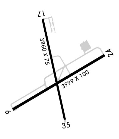 Airport Diagram might not be current. | |
| Facility Name: | LAKE WALES MUNI |
| City Name: | LAKE WALES |
| County: | POLK |
| State abbrev: | FL |
| State Name: | FLORIDA |
| Ownership: | PUBLICLY OWNED |
| Use: | OPEN TO THE PUBLIC |
| Owner's Name: | LAKE WALES AIRPORT AUTHORITY; CONTACT PERSON: KENNETH FIELDS |
| Address: | CITY ADMINISTRATION BUILDING, 201 CENTRAL AVENUE WEST |
| LAKE WALES, FL 33853-1320 | |
| Owner's Phone: | 863-678-4182 |
| Manager's Name: | AMANDA KIRBY |
| Address: | 450 SOUTH AIRPORT ROAD |
| LAKE WALES, FL 33859-1320 | |
| Phone: | (863) 678-0080 |
| FAA Region: | SOUTHERN |
| FAA Field Office: | ORL |

| Date | Sunrise | Sunset |
|---|---|---|
| 09/24/21 Friday | 7:16 | 19:21 |
| 09/25/21 Saturday | 7:16 | 19:20 |
| 09/26/21 Sunday | 7:17 | 19:19 |
| 09/27/21 Monday | 7:17 | 19:17 |
| 09/28/21 Tuesday | 7:18 | 19:16 |
| 09/29/21 Wednesday | 7:18 | 19:15 |
| 09/30/21 Thursday | 7:19 | 19:14 |
| 10/01/21 Friday | 7:19 | 19:13 |
| 10/02/21 Saturday | 7:20 | 19:12 |
| 10/03/21 Sunday | 7:20 | 19:10 |
| 10/04/21 Monday | 7:21 | 19:09 |
| 10/05/21 Tuesday | 7:21 | 19:08 |
| 10/06/21 Wednesday | 7:22 | 19:07 |
| 10/07/21 Thursday | 7:22 | 19:06 |
| Airport Attendance Schedule | 7 Days A Week 0800-1700 |
| Airport Status | OPERATIONAL (This Status can change at any time - please check NOTAMS) |
| Airport Lighting Schedule | ACTVT REIL RWY 6 & 24; PAPI RWY 17 & 35; MIRL RWY 6/ 24 - CTAF. PAPI 6 & 24 OPR CONSLY. |
| Airport Storage Available | Tie Downs |
| Extra Services Available | Parachute Jumping |
| Wind Indicator | YES - (lighted) |
| Control Tower | NO |
| CTAF Frequency | 122.800 |
| Unicom Frequency | 122.800 |
| Rotating Beacon Color | CLEAR-GREEN (Light Land Airport) |
| Segmented Circle | Y-L |
| Landing Fee | NO |
| Airport Inspected | STATE - performed by STATE AERONAUTICAL PERSONNEL |
| Inspection Date | 07/25/2018 |
| Type of Fuel Available | Grade 100LL, JET A (freeze point -40C); -10FUEL AVBL 24 HR CREDIT CARD SVC. |
| Airframe Repair Service | NONE |
| Power Plant Repair Service | NONE |
| Latitude | N2753.6 |
| Longitude | W08137.3 (ESTIMATED) |
| Arpt Elevation | 126ft (SURVEYED) |
| Magnetic Variation | 03W |
| 2 miles W | of LAKE WALES |
| Traffic Pattern Altitude | |
| Sectional Chart | MIAMI |
| Operations (Reported) | Yearly | Avg. Daily |
|---|---|---|
| General Aviation Transient | 5094 | 14 |
| General Aviation Local | 13986 | 38 |
| Air Taxi | 800 | 2 |
| Commerical | 0 | 0 |
| Commuter | 0 | 0 |
| Military | 120 | 0 |
| Aircraft based on Field | |
|---|---|
| General Aviation Singles | 12 |
| General Aviation Multi | 1 |
| Jet Aircraft | 0 |
| General Aviation Helicopters | 2 |
| Military Aircraft | 0 |
| Gliders | 1 |
| Ultralights | 2 |
| FSS on field | NO |
| FSS tie-in | SAINT PETERSBURG |
| FSS Phone | 1-800-WX-BRIEF |
| Who issues Notams | PIE |
| Notam D service at airport | YES |
| ARTCC Name | MIAMI |
| Airport Certification | |
| Aircraft Rescue & Firefighting Index | None |
| Airport of Entry | No |
| Custom Landing Rights | No |
| Joint Civil/Military | No |
| Military Landing rights | YES |
| NATIONAL PLAN OF INTEGRATED AIRPORT SYSTEMS (NPIAS) |
| GRANT AGREEMENTS UNDER FAAP/ADAP/AIP |
| ASSURANCES PURSUANT TO TITLE VI, CIVIL RIGHTS ACT OF 1964 |
| AGREEMENT UNDER DLAND OR DCLA HAS EXPIRED. |
| ULTRALIGHT ACTIVITY ON & INVOF ARPT. |
| TREES IN TRANSITIONAL SFC RY 17; APCH WEST OF RY. |
| RY 17 4 FT FENCE 205 FT FM RY END AT RY HEIGHT. |
| FOR CD CTC MIAMI ARTCC AT 305-716-1731. |
Airport Communications & Frequencies:
| |||||||||
| Runway: 06 | Runway: 24 | ||
| Mag heading: | 62° | Mag heading: | 242° |
| Rwy Slope: | -.04% Down | Rwy Slope: | .04% Up |
| Approach: | Approach: | ||
| Pattern: | Left Traffic | Pattern: | Left Traffic |
| Markings: | NONPRECISION INSTRUMENT | Markings: | NONPRECISION INSTRUMENT |
| Marking Condition: | GOOD | Marking Condition: | GOOD |
| Arresting Dev: | Arresting Dev: | ||
| Lat & Long: | N2753.3 W08137.8 | Lat. & Long.: | N2753.8 W08136.9 |
| Elev: | 123.4 ft. MSL | Elev: | 121.4 ft. MSL |
| TCH: | 44 ft. AGL | TCH: | 44 ft. AGL |
| Visual Glide Path: | 3.50 degrees | Visual Glide Path: | 3.50 degrees |
| Displaced Threshold: | No | Displaced Threshold: | No |
| Touchdown Zone: | YES | Touchdown Zone: | YES |
| Touchdown Elev.: | 126.7 feet | Touchdown Elev.: | 126.7 feet |
| Visual Glide Slope: | 4-Light PAPI on LEFT side of Runway | Visual Glide Slope: | 4-Light PAPI on LEFT side of Runway |
| RVR Equipment: | RVR Equipment: | ||
| RVV Equipment: | NO | RVV Equipment: | NO |
| Approach Lights: | Approach Lights: | ||
| REIL: | YES | REIL: | YES |
| Centerline Lights: | NO | Centerline Lights: | NO |
| Touchdown lights: | NO | Touchdown lights: | NO |
| Runway Category: | Runway with a Non-precision Approach | Runway Category: | Runway with a Non-precision Approach |
| Declared Distances: | Declared Distances: | ||
| Obstructions: | TREES | Obstructions: | TREES |
| Marked: | NOT Marked/Lighted | Marked: | NOT Marked/Lighted |
| Clearance slope: | 31:1 | Clearance slope: | 31:1 |
| Obstruction height: | 36 feet AGL | Obstruction height: | 51 feet AGL |
| Dist. from runway: | 1305 feet | Dist. from runway: | 1770 feet |
| Centerline offset: | 300 left of centerline | Centerline offset: | 165 feet right of centerline |
| Comments: | Comments: |
| Runway: 17 | Runway: 35 | ||
| Mag heading: | 170° | Mag heading: | 350° |
| Rwy Slope: | -.03% Down | Rwy Slope: | .03% Up |
| Approach: | Approach: | ||
| Pattern: | Left Traffic | Pattern: | Left Traffic |
| Markings: | BASIC | Markings: | BASIC |
| Marking Condition: | FAIR | Marking Condition: | FAIR |
| Arresting Dev: | Arresting Dev: | ||
| Lat & Long: | N2754.0 W08137.3 | Lat. & Long.: | N2753.4 W08137.2 |
| Elev: | 123.6 ft. MSL | Elev: | 122.3 ft. MSL |
| TCH: | 45 ft. AGL | TCH: | 32 ft. AGL |
| Visual Glide Path: | 3.37 degrees | Visual Glide Path: | 3.00 degrees |
| Displaced Threshold: | No | Displaced Threshold: | No |
| Touchdown Zone: | YES | Touchdown Zone: | YES |
| Touchdown Elev.: | 126.4 feet | Touchdown Elev.: | 126.4 feet |
| Visual Glide Slope: | 2-Light PAPI on RIGHT side of Runway | Visual Glide Slope: | 2-Light PAPI on LEFT side of Runway |
| RVR Equipment: | RVR Equipment: | ||
| RVV Equipment: | NO | RVV Equipment: | NO |
| Approach Lights: | Approach Lights: | ||
| REIL: | NO | REIL: | NO |
| Centerline Lights: | NO | Centerline Lights: | NO |
| Touchdown lights: | NO | Touchdown lights: | NO |
| Runway Category: | Runway with a Visual Approach | Runway Category: | Runway with a Visual Approach |
| Declared Distances: | Declared Distances: | ||
| Obstructions: | TREE | Obstructions: | BRUSH |
| Marked: | NOT Marked/Lighted | Marked: | NOT Marked/Lighted |
| Clearance slope: | 5:1 | Clearance slope: | 29:1 |
| Obstruction height: | 38 feet AGL | Obstruction height: | 3 feet AGL |
| Dist. from runway: | 415 feet | Dist. from runway: | 280 feet |
| Centerline offset: | 125 right of centerline | Centerline offset: | 30 feet right of centerline |
| Comments: | Comments: |
Thanks for using FltPlan.com
all rights reserved © 1999-2021 by Flight Plan LLC