
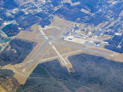
| CAPE MAY COUNTY WILDWOOD NJ |
| |
| Lat: N 3900.5 Long: W 07454.5 Elev: 22 Var: +10 Longest Runway: 5252 | ||
| Clr Del: 121.7 AWOS: 118.27 CTAF: 122.7 | ||
| ||||||||||||||||||||||||||||||||||||||||||||
| ||||||||||||||||||||||||||||||||||||||||||||
| ||||||||||||||||||||||||||||||||||||||||||||
| Rwy | Rwy | |||||||
| 5252x150 | 5252' | 5252x150 | 5037' | 108.90 - 189° | ||||
| 5000x150 | 5000' | 5000x150 | 5000' | |||||
| Runway ID | Single Wheel | Double Wheel | Double Tandem Wheel | Dual Double Wheel |
| 01/19 | 83,000 | 121,000 | 190,000 | N/A |
| 10/28 | 45,000 | 75,000 | 120,000 | N/A |
| These numbers are Advisory and are not limits. The Airport Manager should have more accurate Weight Limits | ||||
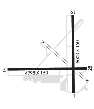 Airport Diagram might not be current. | |
| Facility Name: | CAPE MAY COUNTY |
| City Name: | WILDWOOD |
| County: | CAPE MAY |
| State abbrev: | NJ |
| State Name: | NEW JERSEY |
| Ownership: | PUBLICLY OWNED |
| Use: | OPEN TO THE PUBLIC |
| Owner's Name: | DELAWARE RIVER BAY AUTHORITY; DRBA IS LESSEE. PROPERTY OWNED BY CAPE MAY COUNTY, PO BOX 365, CAPE MAY COURT HOUSE, N.J. 08210. 609-886-0901. |
| Address: | PO BOX 71 |
| NEW CASTLE, DE 19720 | |
| Owner's Phone: | 609-224-0303 |
| Manager's Name: | JOE MULHERON |
| Address: | 201 FORRESTAL RD |
| RIO GRANDE, NJ 08242 | |
| Phone: | 302-757-2952 |
| FAA Region: | EASTERN |
| FAA Field Office: | HAR |
| Date | Sunrise | Sunset |
|---|---|---|
| 06/08/26 Monday | 5:34 | 20:24 |
| 06/09/26 Tuesday | 5:34 | 20:24 |
| 06/10/26 Wednesday | 5:34 | 20:25 |
| 06/11/26 Thursday | 5:33 | 20:25 |
| 06/12/26 Friday | 5:33 | 20:26 |
| 06/13/26 Saturday | 5:33 | 20:26 |
| 06/14/26 Sunday | 5:33 | 20:27 |
| 06/15/26 Monday | 5:33 | 20:27 |
| 06/16/26 Tuesday | 5:33 | 20:27 |
| 06/17/26 Wednesday | 5:33 | 20:28 |
| 06/18/26 Thursday | 5:34 | 20:28 |
| 06/19/26 Friday | 5:34 | 20:28 |
| 06/20/26 Saturday | 5:34 | 20:28 |
| 06/21/26 Sunday | 5:34 | 20:29 |
| Airport Attendance Schedule | 7 Days A Week 0800-1700 |
| Airport Status | OPERATIONAL (This Status can change at any time - please check NOTAMS) |
| Airport Lighting Schedule | ACTVT PAPI RWY 01, 10, 19, & 28; HIRL RWY 01/19; MIRL RWY 10/28 - CTAF. |
| Airport Storage Available | Tie Downs, Hanger |
| Extra Services Available | Flight Instruction |
| Wind Indicator | YES - (lighted) |
| Control Tower | NO |
| CTAF Frequency | 122.700 |
| Unicom Frequency | 122.700 |
| Rotating Beacon Color | WG |
| Segmented Circle | NO |
| Landing Fee | NO |
| Airport Inspected | FEDERAL - performed by STATE AERONAUTICAL PERSONNEL |
| Inspection Date | 03/03/2026 |
| Type of Fuel Available | Grade 100LL, JET A (freeze point -40C); -10SELF SERV AVBL H24 WITH CREDIT CARD LCTD ON APRON NEAR INTXN OF TWY A & F. |
| Airframe Repair Service | MINOR |
| Power Plant Repair Service | MINOR |
| Latitude | N3900.5 |
| Longitude | W07454.5 (ESTIMATED) |
| Arpt Elevation | 21ft (SURVEYED) |
| Magnetic Variation | 10W |
| 4 miles NW | of WILDWOOD |
| Traffic Pattern Altitude | |
| Sectional Chart | WASHINGTON |
| Operations (Reported) | Yearly | Avg. Daily |
|---|---|---|
| General Aviation Transient | 0 | 0 |
| General Aviation Local | 0 | 0 |
| Air Taxi | 0 | 0 |
| Commerical | 0 | 0 |
| Commuter | 0 | 0 |
| Military | 0 | 0 |
| Aircraft based on Field | |
|---|---|
| General Aviation Singles | 0 |
| General Aviation Multi | 0 |
| Jet Aircraft | 0 |
| General Aviation Helicopters | 0 |
| Military Aircraft | 0 |
| Gliders | 0 |
| Ultralights | 0 |
| FSS on field | NO |
| FSS tie-in | MILLVILLE |
| FSS Phone | 1-800-WX-BRIEF |
| Who issues Notams | WWD |
| Notam D service at airport | YES |
| ARTCC Name | WASHINGTON |
| Airport Certification | |
| Aircraft Rescue & Firefighting Index | None |
| Airport of Entry | No |
| Custom Landing Rights | No |
| Joint Civil/Military | No |
| Military Landing rights | YES |
| NATIONAL PLAN OF INTEGRATED AIRPORT SYSTEMS (NPIAS) |
| GRANT AGREEMENTS UNDER FAAP/ADAP/AIP |
| SURPLUS PROPERTY AGREEMENT UNDER REGULATION 16-WAA |
| ASSURANCES PURSUANT TO TITLE VI, CIVIL RIGHTS ACT OF 1964 |
| AGREEMENT UNDER DLAND OR DCLA HAS EXPIRED. |
| BIRDS ON & INVOF ARPT. |
| PAEW WITHIN THE SAFETY AREAS OF ALL RYS AND TWYS DAILY MAY THRU OCT. |
| TWY A WEST OF TWY F CAN ONLY BE USED BY ACFT WITH WINGSPANS LESS THAN 79 FT. |
| UNMANNED AIRCRAFT SYSTEMS (UAS) ACTIVITY ON AND AROUND AIRFIELD. |
| ALL ULTRALIGHT ACFT, GLIDER OPS AND FORMATION FLTS PPR. CALL (609) 886-8652 MON-FRI 0800-1600. |
| FOR CD CTC ATLANTIC CITY APCH AT 609-485-6192. |
| TWY C IS AN FAA RESEARCH TWY AND IS RSTRD TO ACFT WITH WT LMT OF 28,000 LB AND SHOULD NOT BE USED BY ACFT GTR THAN 28,000 LB. |
| ARPT SFC CONDS NOT RPRTD 0800-1600. |
| TWY B SOUTH OF TWY A CAN ONLY BE USED BY ACFT WITH WINGSPANS LESS THAN 79 FT. |
| RWY 19 CALM WIND RWY. |
Airport Communications & Frequencies:
| ||||||||||||||||
| Runway: 01 | Runway: 19 | ||
| Mag heading: | 10° | Mag heading: | 190° |
| Rwy Slope: | -.12% Down | Rwy Slope: | .12% Up |
| Approach: | Approach: | LOCALIZER | |
| Pattern: | Left Traffic | Pattern: | Left Traffic |
| Markings: | NONPRECISION INSTRUMENT | Markings: | NONPRECISION INSTRUMENT |
| Marking Condition: | GOOD | Marking Condition: | GOOD |
| Arresting Dev: | Arresting Dev: | ||
| Lat & Long: | N3900.1 W07454.3 | Lat. & Long.: | N3901.0 W07454.3 |
| Elev: | 21.7 ft. MSL | Elev: | 15.2 ft. MSL |
| TCH: | 40 ft. AGL | TCH: | 40 ft. AGL |
| Visual Glide Path: | 3.00 degrees | Visual Glide Path: | 3.00 degrees |
| Displaced Threshold: | No | Displaced Threshold: | 215 feet |
| Touchdown Zone: | YES | Touchdown Zone: | YES |
| Touchdown Elev.: | 21.7 feet | Touchdown Elev.: | 18.5 feet |
| Visual Glide Slope: | 4-Light PAPI on LEFT side of Runway | Visual Glide Slope: | 4-Light PAPI on LEFT side of Runway |
| RVR Equipment: | RVR Equipment: | ||
| RVV Equipment: | NO | RVV Equipment: | NO |
| Approach Lights: | Approach Lights: | ||
| REIL: | NO | REIL: | NO |
| Centerline Lights: | NO | Centerline Lights: | NO |
| Touchdown lights: | NO | Touchdown lights: | NO |
| Runway Category: | Runway with a Non-precision Approach having visibility minimums greater than 3/4 mile | Runway Category: | Runway with a Non-precision Approach having visibility minimums greater than 3/4 mile |
| Declared Distances: | TORA:5252' TODA:5252' ASDA:5036' LDA:5036' | Declared Distances: | TORA:5252' TODA:5252' ASDA:5252' LDA:5036' |
| Obstructions: | TREE | Obstructions: | ROAD |
| Marked: | NOT Marked/Lighted | Marked: | NOT Marked/Lighted |
| Clearance slope: | 17:1 | Clearance slope: | 4:1; APCH RATIO 22:1 TO DSPLCD THR. |
| Obstruction height: | 55 feet AGL | Obstruction height: | 13 feet AGL |
| Dist. from runway: | 1140 feet | Dist. from runway: | 260 feet |
| Centerline offset: | 130 left of centerline | Centerline offset: | |
| Comments: | Comments: |
| Runway: 10 | Runway: 28 | ||
| Mag heading: | 100° | Mag heading: | 280° |
| Rwy Slope: | .07% Up | Rwy Slope: | -.07% Down |
| Approach: | Approach: | ||
| Pattern: | Left Traffic | Pattern: | Left Traffic |
| Markings: | NONPRECISION INSTRUMENT | Markings: | NONPRECISION INSTRUMENT |
| Marking Condition: | GOOD | Marking Condition: | GOOD |
| Arresting Dev: | Arresting Dev: | ||
| Lat & Long: | N3900.4 W07455.2 | Lat. & Long.: | N3900.4 W07454.2 |
| Elev: | 15.5 ft. MSL | Elev: | 19.0 ft. MSL |
| TCH: | 45 ft. AGL | TCH: | 57 ft. AGL |
| Visual Glide Path: | 3.00 degrees | Visual Glide Path: | 3.00 degrees |
| Displaced Threshold: | No | Displaced Threshold: | No |
| Touchdown Zone: | YES | Touchdown Zone: | YES |
| Touchdown Elev.: | 17.6 feet | Touchdown Elev.: | 19.3 feet |
| Visual Glide Slope: | 4-Light PAPI on LEFT side of Runway | Visual Glide Slope: | 4-Light PAPI on LEFT side of Runway |
| RVR Equipment: | RVR Equipment: | ||
| RVV Equipment: | NO | RVV Equipment: | NO |
| Approach Lights: | Approach Lights: | ||
| REIL: | NO | REIL: | NO |
| Centerline Lights: | NO | Centerline Lights: | NO |
| Touchdown lights: | NO | Touchdown lights: | NO |
| Runway Category: | Runway with a Non-precision Approach having visibility minimums greater than 3/4 mile | Runway Category: | Runway with a Non-precision Approach having visibility minimums greater than 3/4 mile |
| Declared Distances: | Declared Distances: | ||
| Obstructions: | TREES | Obstructions: | TOWER |
| Marked: | NOT Marked/Lighted | Marked: | NOT Marked/Lighted |
| Clearance slope: | 22:1 | Clearance slope: | 30:1 |
| Obstruction height: | 80 feet AGL | Obstruction height: | 297 feet AGL |
| Dist. from runway: | 2000 feet | Dist. from runway: | 9290 feet |
| Centerline offset: | Centerline offset: | 660 feet right of centerline | |
| Comments: | Comments: |
Thanks for using FltPlan.com
all rights reserved © 1999-2026 by Flight Plan LLC