| WATERVILLE ROBERT LAFLEUR WATERVILLE ME |
| |
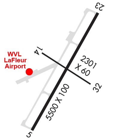
| Lat: N 4432.0 Long: W 06940.5 Elev: 333 Var: +18 Longest Runway: 5500 | ||
| Clr Del: 124.6 AWOS: 118.37 CTAF: 122.7 | ||
| |||||||||||||||||||||||||||||||||||||||||||||||||||||||||||||||||||||
| |||||||||||||||||||||||||||||||||||||||||||||||||||||||||||||||||||||
| |||||||||||||||||||||||||||||||||||||||||||||||||||||||||||||||||||||
| Rwy | Rwy | |||||||
| 5500x100 | 5500' | 110.50 - 047° | 5500x100 | 5500' | ||||
| 2301x60 | 2301' | 2301x60 | 2301' | |||||
| Runway ID | Single Wheel | Double Wheel | Double Tandem Wheel | Dual Double Wheel |
| 05/23 | 40,000 | 60,000 | 105,000 | N/A |
| 14/32 | 25,000 | N/A | N/A | N/A |
| These numbers are Advisory and are not limits. The Airport Manager should have more accurate Weight Limits | ||||
 Airport Diagram might not be current. | |
| Facility Name: | WATERVILLE ROBERT LAFLEUR |
| City Name: | WATERVILLE |
| County: | KENNEBEC |
| State abbrev: | ME |
| State Name: | MAINE |
| Ownership: | PUBLICLY OWNED |
| Use: | OPEN TO THE PUBLIC |
| Owner's Name: | CITY OF WATERVILLE |
| Address: | 1 COMMON ST, 1 COMMON ST |
| WATERVILLE, ME 04901 | |
| Owner's Phone: | (207) 861-8013 |
| Manager's Name: | RANDY MARSHALL JR |
| Address: | 2 LAFLUER RD, 1 COMMON STREET |
| WATERVILLE, ME 04901 | |
| Phone: | 207-861-8013; WVLAIRPORT@WATERVILLE-ME.GOV. |
| FAA Region: | NEW ENGLAND |
| FAA Field Office: | NONE |

| Date | Sunrise | Sunset |
|---|---|---|
| 09/24/21 Friday | 6:28 | 18:33 |
| 09/25/21 Saturday | 6:29 | 18:31 |
| 09/26/21 Sunday | 6:30 | 18:29 |
| 09/27/21 Monday | 6:31 | 18:27 |
| 09/28/21 Tuesday | 6:33 | 18:25 |
| 09/29/21 Wednesday | 6:34 | 18:24 |
| 09/30/21 Thursday | 6:35 | 18:22 |
| 10/01/21 Friday | 6:36 | 18:20 |
| 10/02/21 Saturday | 6:37 | 18:18 |
| 10/03/21 Sunday | 6:39 | 18:16 |
| 10/04/21 Monday | 6:40 | 18:14 |
| 10/05/21 Tuesday | 6:41 | 18:12 |
| 10/06/21 Wednesday | 6:42 | 18:11 |
| 10/07/21 Thursday | 6:44 | 18:09 |
| Airport Attendance Schedule | MAY-OCT 7 Days A Week 0900-1700, NOV-APR 7 Days A Week 0800-1600 |
| Airport Status | OPERATIONAL (This Status can change at any time - please check NOTAMS) |
| Airport Lighting Schedule | SS-SR |
| Airport Storage Available | Tie Downs, Hanger |
| Extra Services Available | Charter, Flight Instruction, Parachute Jumping, Aircraft Rental |
| Wind Indicator | YES - (lighted) |
| Control Tower | NO |
| CTAF Frequency | 122.700 |
| Unicom Frequency | 122.700 |
| Rotating Beacon Color | CLEAR-GREEN (Light Land Airport) |
| Segmented Circle | YES |
| Landing Fee | NO |
| Airport Inspected | STATE - performed by PRIVATE CONTRACT PERSONNEL |
| Inspection Date | 08/26/2020 |
| Type of Fuel Available | Grade 100LL, JET A; -10FOR FUEL AFT HRS E-MAIL WVLAIRPORT@WATERVILLE-ME.GOV (FEE CHRGD). |
| Airframe Repair Service | NONE |
| Power Plant Repair Service | NONE |
| Latitude | N4432.0 |
| Longitude | W06940.5 (ESTIMATED) |
| Arpt Elevation | 332ft (SURVEYED) |
| Magnetic Variation | 18W |
| 2 miles SW | of WATERVILLE |
| Traffic Pattern Altitude | |
| Sectional Chart | MONTREAL |
| Operations (Reported) | Yearly | Avg. Daily |
|---|---|---|
| General Aviation Transient | 8000 | 22 |
| General Aviation Local | 8000 | 22 |
| Air Taxi | 0 | 0 |
| Commerical | 0 | 0 |
| Commuter | 0 | 0 |
| Military | 200 | 1 |
| Aircraft based on Field | |
|---|---|
| General Aviation Singles | 18 |
| General Aviation Multi | 2 |
| Jet Aircraft | 0 |
| General Aviation Helicopters | 0 |
| Military Aircraft | 0 |
| Gliders | 0 |
| Ultralights | 0 |
| FSS on field | NO |
| FSS tie-in | BANGOR |
| FSS Phone | 1-800-WX-BRIEF |
| Who issues Notams | WVL |
| Notam D service at airport | YES |
| ARTCC Name | BOSTON |
| Airport Certification | |
| Aircraft Rescue & Firefighting Index | None |
| Airport of Entry | No |
| Custom Landing Rights | No |
| Joint Civil/Military | No |
| Military Landing rights | YES |
| NATIONAL PLAN OF INTEGRATED AIRPORT SYSTEMS (NPIAS) |
| GRANT AGREEMENTS UNDER FAAP/ADAP/AIP |
| ASSURANCES PURSUANT TO TITLE VI, CIVIL RIGHTS ACT OF 1964 |
| AGREEMENT UNDER DLAND OR DCLA HAS EXPIRED. |
| THIS AIRPORT HAS BEEN SURVEYED BY THE NATIONAL GEODETIC SURVEY. |
| ACFT OPNS ON PAVED AREA ONLY. |
| AVOID HOSPITAL 1 MI NORTH. |
| ACFT DE-ICING AVBL. |
| FOR CD WHEN APCH CLSD CTC BOSTON ARTCC AT 603-879-6859. |
Airport Communications & Frequencies:
| |||||||||||||||||||||
| Runway: 05 | Runway: 23 | ||
| Mag heading: | 47° | Mag heading: | 227° |
| Rwy Slope: | 1.18% Up | Rwy Slope: | -1.18% Down |
| Approach: | ILS/DME | Approach: | |
| Pattern: | Left Traffic | Pattern: | Left Traffic |
| Markings: | PRECISION INSTRUMENT | Markings: | PRECISION INSTRUMENT |
| Marking Condition: | POOR; NRS & CNTRLN FADED. | Marking Condition: | POOR; NRS & CNTRLN FADED. |
| Arresting Dev: | Arresting Dev: | ||
| Lat & Long: | N4431.6 W06940.8 | Lat. & Long.: | N4432.4 W06940.2 |
| Elev: | 267.9 ft. MSL | Elev: | 332.8 ft. MSL |
| TCH: | 51 ft. AGL | TCH: | 40 ft. AGL |
| Visual Glide Path: | 3.00 degrees | Visual Glide Path: | 3.00 degrees |
| Displaced Threshold: | No | Displaced Threshold: | No |
| Touchdown Zone: | YES | Touchdown Zone: | YES |
| Touchdown Elev.: | 308.6 feet | Touchdown Elev.: | 332.8 feet |
| Visual Glide Slope: | 4-BOX VASI ON LEFT SIDE OF RUNWAY | Visual Glide Slope: | 4-Light PAPI on LEFT side of Runway |
| RVR Equipment: | RVR Equipment: | ||
| RVV Equipment: | NO | RVV Equipment: | NO |
| Approach Lights: | MALSF - 1,400 foot medium intensity approach lighting system with sequenced flashers | Approach Lights: | |
| REIL: | NO | REIL: | YES |
| Centerline Lights: | NO | Centerline Lights: | NO |
| Touchdown lights: | NO | Touchdown lights: | NO |
| Runway Category: | Precision Instrument Runway | Runway Category: | Runway with a Non-precision Approach having visibility minimums greater than 3/4 mile |
| Declared Distances: | Declared Distances: |
| Runway: 14 | Runway: 32 | ||
| Mag heading: | 143° | Mag heading: | 323° |
| Rwy Slope: | -.39% Down | Rwy Slope: | .39% Up |
| Approach: | Approach: | ||
| Pattern: | Left Traffic | Pattern: | Left Traffic |
| Markings: | BASIC | Markings: | BASIC |
| Marking Condition: | GOOD | Marking Condition: | GOOD |
| Arresting Dev: | Arresting Dev: | ||
| Lat & Long: | N4432.1 W06940.7 | Lat. & Long.: | N4431.9 W06940.3 |
| Elev: | 307.6 ft. MSL | Elev: | 298.6 ft. MSL |
| TCH: | TCH: | ||
| Visual Glide Path: | Visual Glide Path: | ||
| Displaced Threshold: | No | Displaced Threshold: | No |
| Touchdown Zone: | YES | Touchdown Zone: | YES |
| Touchdown Elev.: | 307.6 feet | Touchdown Elev.: | 307.6 feet |
| Visual Glide Slope: | Visual Glide Slope: | ||
| RVR Equipment: | RVR Equipment: | ||
| RVV Equipment: | NO | RVV Equipment: | NO |
| Approach Lights: | Approach Lights: | ||
| REIL: | NO | REIL: | NO |
| Centerline Lights: | NO | Centerline Lights: | NO |
| Touchdown lights: | NO | Touchdown lights: | NO |
| Runway Category: | Runway with a Visual Approach | Runway Category: | Runway with a Visual Approach |
| Declared Distances: | Declared Distances: | ||
| Obstructions: | TREES | Obstructions: | TREES |
| Marked: | NOT Marked/Lighted | Marked: | NOT Marked/Lighted |
| Clearance slope: | 12:1 | Clearance slope: | 9:1 |
| Obstruction height: | 26 feet AGL | Obstruction height: | 17 feet AGL |
| Dist. from runway: | 519 feet | Dist. from runway: | 365 feet |
| Centerline offset: | 118 left of centerline | Centerline offset: | 125 feet right of centerline |
| Comments: | Comments: |
Thanks for using FltPlan.com
all rights reserved © 1999-2021 by Flight Plan LLC