
| WATSONVILLE MUNI WATSONVILLE CA |
| |
| Lat: N 3656.1 Long: W 12147.4 Elev: 163 Var: -14 Longest Runway: 4502 | ||
| AWOS: 132.27 CTAF: 122.8 | ||
| ||||||||||||||||||||||||||||||||||||||||||||
| ||||||||||||||||||||||||||||||||||||||||||||
| ||||||||||||||||||||||||||||||||||||||||||||
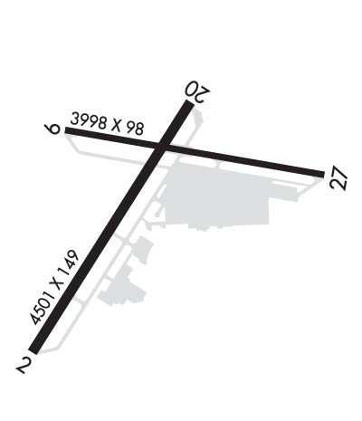
| Rwy | Rwy | |||||||
| 4502x149 | 4502' | 108.30 - 018° | 4502x149 | 3913' | ||||
| 3998x98 | 3998' | 3998x98 | 3998' | |||||
| Runway ID | Single Wheel | Double Wheel | Double Tandem Wheel | Dual Double Wheel |
| 02/20 | 81,000 | 96,000 | 167,000 | N/A |
| 09/27 | 45,000 | 65,000 | N/A | N/A |
| H1 | N/A | N/A | N/A | N/A |
| H2 | N/A | N/A | N/A | N/A |
| These numbers are Advisory and are not limits. The Airport Manager should have more accurate Weight Limits | ||||
 Airport Diagram might not be current. | |
| Facility Name: | WATSONVILLE MUNI |
| City Name: | WATSONVILLE |
| County: | SANTA CRUZ |
| State abbrev: | CA |
| State Name: | CALIFORNIA |
| Ownership: | PUBLICLY OWNED |
| Use: | OPEN TO THE PUBLIC |
| Owner's Name: | CITY OF WATSONVILLE |
| Address: | 275 MAIN ST |
| WATSONVILLE, CA 95076 | |
| Owner's Phone: | 831-768-3575 |
| Manager's Name: | RAYVON WILLIAMS; RAYVON.WILLIAMS@CITYOFWATSONVILLE.ORG |
| Address: | 100 AVIATION WAY |
| WATSONVILLE, CA 95076 | |
| Phone: | 831-768-3575 |
| FAA Region: | WESTERN-PACIFIC |
| FAA Field Office: | SFO |

| Date | Sunrise | Sunset |
|---|---|---|
| 06/08/26 Monday | 5:47 | 20:25 |
| 06/09/26 Tuesday | 5:47 | 20:26 |
| 06/10/26 Wednesday | 5:47 | 20:26 |
| 06/11/26 Thursday | 5:47 | 20:27 |
| 06/12/26 Friday | 5:47 | 20:27 |
| 06/13/26 Saturday | 5:47 | 20:27 |
| 06/14/26 Sunday | 5:47 | 20:28 |
| 06/15/26 Monday | 5:47 | 20:28 |
| 06/16/26 Tuesday | 5:47 | 20:29 |
| 06/17/26 Wednesday | 5:47 | 20:29 |
| 06/18/26 Thursday | 5:47 | 20:29 |
| 06/19/26 Friday | 5:48 | 20:29 |
| 06/20/26 Saturday | 5:48 | 20:30 |
| 06/21/26 Sunday | 5:48 | 20:30 |
| Airport Attendance Schedule | 7 Days A Week 0900-1700 |
| Airport Status | OPERATIONAL (This Status can change at any time - please check NOTAMS) |
| Airport Lighting Schedule | ACTVT PAPI RWY 02, 09 & 20; REIL RWY 02; MIRL RWY 02/20 - CTAF. |
| Airport Storage Available | Tie Downs |
| Extra Services Available | Avionics, Charter, Flight Instruction, Parachute Jumping, Aircraft Rental, Aircraft Sales, Annual Surveying |
| Wind Indicator | YES - (lighted) |
| Control Tower | NO |
| CTAF Frequency | 122.800 |
| Unicom Frequency | 122.800 |
| Rotating Beacon Color | WG |
| Segmented Circle | YES |
| Landing Fee | NO |
| Airport Inspected | STATE - performed by STATE AERONAUTICAL PERSONNEL |
| Inspection Date | 03/28/2024 |
| Type of Fuel Available | Grade 100LL, JET A (freeze point -40C)G100 |
| Airframe Repair Service | MINOR |
| Power Plant Repair Service | MAJOR |
| Latitude | N3656.1 |
| Longitude | W12147.4 (ESTIMATED) |
| Arpt Elevation | 163ft (SURVEYED) |
| Magnetic Variation | 14E |
| 3 miles NW | of WATSONVILLE |
| Traffic Pattern Altitude | |
| Sectional Chart | SAN FRANCISCO |
| Operations (Reported) | Yearly | Avg. Daily |
|---|---|---|
| General Aviation Transient | 0 | 0 |
| General Aviation Local | 0 | 0 |
| Air Taxi | 0 | 0 |
| Commerical | 0 | 0 |
| Commuter | 0 | 0 |
| Military | 0 | 0 |
| Aircraft based on Field | |
|---|---|
| General Aviation Singles | 0 |
| General Aviation Multi | 0 |
| Jet Aircraft | 0 |
| General Aviation Helicopters | 0 |
| Military Aircraft | 0 |
| Gliders | 0 |
| Ultralights | 0 |
| FSS on field | NO |
| FSS tie-in | OAKLAND |
| FSS Phone | 1-800-WX-BRIEF |
| Who issues Notams | WVI |
| Notam D service at airport | YES |
| ARTCC Name | OAKLAND |
| Airport Certification | |
| Aircraft Rescue & Firefighting Index | None |
| Airport of Entry | No |
| Custom Landing Rights | No |
| Joint Civil/Military | No |
| Military Landing rights | YES |
| NATIONAL PLAN OF INTEGRATED AIRPORT SYSTEMS (NPIAS) |
| GRANT AGREEMENTS UNDER FAAP/ADAP/AIP |
| SURPLUS PROPERTY AGREEMENT UNDER PUBLIC LAW 289 |
| SURPLUS PROPERTY AGREEMENT UNDER REGULATION 16-WAA |
| ASSURANCES PURSUANT TO TITLE VI, CIVIL RIGHTS ACT OF 1964 |
| SEAGULLS ON & INVOF ARPT. |
| FOR CD CTC NORCAL APCH AT 916-361-3748 OR VIA VHF 127.15. |
| ALL DEPS PROHIBITED ON RWY 27 DUE TO RWY VIS BLOCKED BY HNGRS. |
| 130 FT TREES 700 FT RIGHT OF RWY 9 THLD, 85 FT TREES 600 FT LEFT OF RWY 9 THLD. |
| ARPT HAS NOISE ABATEMENT PROCS; SEE ARPT WEBSITE. |
| RWY 20 PREF CALM WIND RWY; STRAIGHT-IN APCH NOT RCMDD. |
| GLIDER TOWING RQRS PRIOR NOTIFICATION, CTC ARPT OFC 831-768-3575. |
| HELICOPTER ACTVTY ON AND INVOF ARPT. |
| COASTAL FOG DURING SUMMER MONTHS. |
| PRCHT OPS ON ARPT DLY 0900-2000; LNDG AREA 1000 FT WEST OF RWY 20. |
Airport Communications & Frequencies:
| ||||||||||||||||||
| Runway: 02 | Runway: 20 | ||
| Mag heading: | 18° | Mag heading: | 198° |
| Rwy Slope: | .40% Up | Rwy Slope: | -.40% Down |
| Approach: | LOCALIZER | Approach: | |
| Pattern: | Left Traffic | Pattern: | Left Traffic |
| Markings: | NONPRECISION INSTRUMENT | Markings: | NONPRECISION INSTRUMENT |
| Marking Condition: | FAIR | Marking Condition: | FAIR |
| Arresting Dev: | Arresting Dev: | ||
| Lat & Long: | N3655.7 W12147.7 | Lat. & Long.: | N3656.4 W12147.3 |
| Elev: | 139.5 ft. MSL | Elev: | 157.7 ft. MSL |
| TCH: | 43 ft. AGL | TCH: | 44 ft. AGL |
| Visual Glide Path: | 3.00 degrees | Visual Glide Path: | 3.00 degrees |
| Displaced Threshold: | No | Displaced Threshold: | 589 feet |
| Touchdown Zone: | YES | Touchdown Zone: | YES |
| Touchdown Elev.: | 151.7 feet | Touchdown Elev.: | 155.4 feet |
| Visual Glide Slope: | 2-Light PAPI on LEFT side of Runway | Visual Glide Slope: | 2-Light PAPI on LEFT side of Runway; UNUSBL BYD 4.0 NM DUE TO TERRAIN. |
| RVR Equipment: | RVR Equipment: | ||
| RVV Equipment: | NO | RVV Equipment: | NO |
| Approach Lights: | Approach Lights: | ||
| REIL: | YES | REIL: | NO |
| Centerline Lights: | NO | Centerline Lights: | NO |
| Touchdown lights: | NO | Touchdown lights: | NO |
| Runway Category: | Runway with a Non-precision Approach having visibility minimums greater than 3/4 mile | Runway Category: | Runway with a Visual Approach |
| Declared Distances: | Declared Distances: | ||
| Obstructions: | TREES | Obstructions: | TREE |
| Marked: | NOT Marked/Lighted | Marked: | NOT Marked/Lighted |
| Clearance slope: | 24:1 | Clearance slope: | 12:1; RWY 20 APCH RATIO 22:1 TO DSPLCD THR. |
| Obstruction height: | 46 feet AGL | Obstruction height: | 80 feet AGL |
| Dist. from runway: | 1310 feet | Dist. from runway: | 1198 feet |
| Centerline offset: | 39 left of centerline | Centerline offset: | 125 feet left of centerline |
| Comments: | Comments: |
| Runway: 09 | Runway: 27 | ||
| Mag heading: | 86° | Mag heading: | 266° |
| Rwy Slope: | -.68% Down | Rwy Slope: | .68% Up |
| Approach: | Approach: | ||
| Pattern: | Left Traffic | Pattern: | Left Traffic |
| Markings: | BASIC | Markings: | BASIC |
| Marking Condition: | FAIR | Marking Condition: | FAIR |
| Arresting Dev: | Arresting Dev: | ||
| Lat & Long: | N3656.3 W12147.6 | Lat. & Long.: | N3656.2 W12146.8 |
| Elev: | 163.3 ft. MSL | Elev: | 136.3 ft. MSL |
| TCH: | 34 ft. AGL | TCH: | |
| Visual Glide Path: | 4.00 degrees | Visual Glide Path: | |
| Displaced Threshold: | No | Displaced Threshold: | No |
| Touchdown Zone: | YES | Touchdown Zone: | YES |
| Touchdown Elev.: | 163.3 feet | Touchdown Elev.: | 157.5 feet |
| Visual Glide Slope: | 2-Light PAPI on RIGHT side of Runway | Visual Glide Slope: | |
| RVR Equipment: | RVR Equipment: | ||
| RVV Equipment: | NO | RVV Equipment: | NO |
| Approach Lights: | Approach Lights: | ||
| REIL: | NO | REIL: | NO |
| Centerline Lights: | NO | Centerline Lights: | NO |
| Touchdown lights: | NO | Touchdown lights: | NO |
| Runway Category: | Runway with a Visual Approach | Runway Category: | Runway with a Visual Approach |
| Declared Distances: | Declared Distances: | ||
| Obstructions: | TREE | Obstructions: | TREE |
| Marked: | NOT Marked/Lighted | Marked: | NOT Marked/Lighted |
| Clearance slope: | 22:1 | Clearance slope: | 13:1 |
| Obstruction height: | 38 feet AGL | Obstruction height: | 55 feet AGL |
| Dist. from runway: | 1050 feet | Dist. from runway: | 935 feet |
| Centerline offset: | Centerline offset: | 40 feet right of centerline | |
| Comments: | Comments: |
Thanks for using FltPlan.com
all rights reserved © 1999-2026 by Flight Plan LLC