
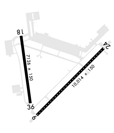
| MC GUIRE AFB (PRIVATE) WRIGHTSTOWN NJ |
| |
| Lat: N 4000.9 Long: W 07435.5 Elev: 141 Var: +12 Longest Runway: 10014 | ||
| Clr Del: 135.2 Dept. ATIS: 110.6 Arr. ATIS: 110.6 Ground: 121.8 Tower: 118.65 | ||
| ||||||||||||||||||||||||||||||||
| ||||||||||||||||||||||||||||||||
| Rwy | Rwy | |||||||
| 10014x150 | 10014' | 110.10 - 057° | 10014x150 | 10014' | 110.10 - 238° | |||
| 7126x150 | 7126' | 7126x150 | 7126' | |||||
| Runway ID | Single Wheel | Double Wheel | Double Tandem Wheel | Dual Double Wheel |
| 06/24 | N/A | N/A | N/A | N/A |
| 18/36 | N/A | N/A | N/A | N/A |
| These numbers are Advisory and are not limits. The Airport Manager should have more accurate Weight Limits | ||||
 Airport Diagram might not be current. | |
| Facility Name: | MC GUIRE FLD (JOINT BASE MC GUIRE DIX LAKEHURST) |
| City Name: | WRIGHTSTOWN |
| County: | BURLINGTON |
| State abbrev: | NJ |
| State Name: | NEW JERSEY |
| Ownership: | AIR FORCE OWNED |
| Use: | PRIVATE |
| Owner's Name: | USAF JB MCGUIRE DIX LAKEHURST |
| Address: | 2901 FALCON LANE |
| MCGUIRE, NJ 08641 | |
| Owner's Phone: | 609-754-2714 |
| Manager's Name: | CHIEF AIRFIELD MANAGEMENT |
| Address: | 2901 FALCON LANE |
| MCGUIRE, NJ 08641 | |
| Phone: | 609-754-6466 |
| FAA Region: | EASTERN |
| FAA Field Office: | HAR |
| Date | Sunrise | Sunset |
|---|---|---|
| 09/24/21 Friday | 6:48 | 18:53 |
| 09/25/21 Saturday | 6:49 | 18:51 |
| 09/26/21 Sunday | 6:49 | 18:49 |
| 09/27/21 Monday | 6:50 | 18:48 |
| 09/28/21 Tuesday | 6:51 | 18:46 |
| 09/29/21 Wednesday | 6:52 | 18:44 |
| 09/30/21 Thursday | 6:53 | 18:43 |
| 10/01/21 Friday | 6:54 | 18:41 |
| 10/02/21 Saturday | 6:55 | 18:39 |
| 10/03/21 Sunday | 6:56 | 18:38 |
| 10/04/21 Monday | 6:57 | 18:36 |
| 10/05/21 Tuesday | 6:58 | 18:35 |
| 10/06/21 Wednesday | 6:59 | 18:33 |
| 10/07/21 Thursday | 7:00 | 18:31 |
| Airport Attendance Schedule | CONTINUOUS |
| Airport Status | OPERATIONAL (This Status can change at any time - please check NOTAMS) |
| Airport Lighting Schedule | |
| Airport Storage Available | Hanger |
| Extra Services Available | Cargo Handling |
| Wind Indicator | YES - (unlit) |
| Control Tower | YES |
| CTAF Frequency | |
| Unicom Frequency | |
| Rotating Beacon Color | CLEAR-GREEN (Light Land Airport) |
| Segmented Circle | NO |
| Landing Fee | NO |
| Airport Inspected | No Inspection Data Available performed by the OWNER |
| Inspection Date | Unknown |
| Type of Fuel Available | None |
| Airframe Repair Service | MAJOR |
| Power Plant Repair Service | MAJOR |
| Latitude | N4000.9 |
| Longitude | W07435.5 (ESTIMATED) |
| Arpt Elevation | 140ft (SURVEYED) |
| Magnetic Variation | 12W |
| 2 miles SE | of WRIGHTSTOWN |
| Traffic Pattern Altitude | TPA FOR HEL 600 FT; LGT ACFT 800 FT; RECTANGULAR 1600 FT; OHD 2100 FT. |
| Sectional Chart | NEW YORK |
| Operations (Reported) | Yearly | Avg. Daily |
|---|---|---|
| General Aviation Transient | 0 | 0 |
| General Aviation Local | 0 | 0 |
| Air Taxi | 0 | 0 |
| Commerical | 0 | 0 |
| Commuter | 0 | 0 |
| Military | 0 | 0 |
| Aircraft based on Field | |
|---|---|
| General Aviation Singles | 0 |
| General Aviation Multi | 0 |
| Jet Aircraft | 0 |
| General Aviation Helicopters | 0 |
| Military Aircraft | 0 |
| Gliders | 0 |
| Ultralights | 0 |
| FSS on field | NO |
| FSS tie-in | NEW YORK |
| FSS Phone | 1-800-WX-BRIEF |
| Who issues Notams | WRI |
| Notam D service at airport | YES |
| ARTCC Name | NEW YORK |
| Airport Certification | |
| Aircraft Rescue & Firefighting Index | None |
| Airport of Entry | YES |
| Custom Landing Rights | No |
| Joint Civil/Military | No |
| Military Landing rights | No |
| SERVICE: AOE. |
| RSTD: DUR FALL BASH ADV, NO SORTIES WILL BE SKED DRG BASH WINDOW WO 305 OG/CC APVL. NOTE: WAIVER APVL TO ARR/DEP DRG BASH WINDOW DOES NOT CONSTITUTE APVL TO ARR/DEP IN BWC SEV. NO LCL TRSN TRNG WILL BE ACCOMPLISHED IN BASH WINDOW. SKED ARR/DEP DRG BASH WINDOW MAY BE DELAYED OR DIVERTED TO ALTN LOCATION IN EVENT THAT BWC IS ELEVATED. USAF ACFT RQR 305 OG/CC APVL FOR DEP/ARR WHEN BWC SEVERE. TENANT UNITS RQR APVL OF THEIR OG/CC OR SVC EQUIVALENT. COORD WAIVERS THRU COMD POST. |
| MISC: ALL TSFR ACFT RQR PPR. |
| RSTD: ALL INBD PAX/CARGO ACFT CTC COMD POST NO LATER THAN 30 MIN PRIOR TO LDG. |
| CAUTION: RWY 18/36 LANDING ZONE MARKINGS MID-FIELD. |
| JASU: (C26) (MD-3) 6(MA-1A) (MA-1). |
| REMARK: 72 HR PPR FOR ARMY RAMP AND LDG ALL ICTN ON FT DIX RESERVATION DSN 562-6377/5287. |
| RWY: RWY 18/36 HAS 200 FT ASPHALT NON-GROOVED OVRN. |
| ASA RAMP OPR 1230-2130Z WKD. WKEND HR BY PRIOR APVL. FAC LCTD ON SW SIDE OF AFLD. 72 HR PPR FOR ARMY RAMP AND LDG ALL LCTN ON FT DIX RESERVAION DSN 944-6377/5287, C609-562-6377/5287. TRAN ACFT CTC ARMY OPS PRIOR TO LDG. |
| FUEL: A++ |
| MISC: ALL CLASSIFIED MATERIAL MUST BE STORED AT THE JB COMD POST DSN 650-3935/3936. AFLD MGMT HAS NO CLASSIFIED STORAGE CAPABILITIES. |
| MISC: FIRST 431 FT RWY 36 CONC REMAINING 6695 FT ASPH. |
| CAUTION: NSTD MRK ON VICTOR ROW FOR ALERT MSN, X-RAY ROW (PRIM), AND ROMEO ROW (ALTN) FOR COMBAT OFF LOAD OPS. |
| FLUID: SP PRESAIR LHOX LOX (C-5, KC-10, 747 DE-ICING LTD TO WG ONLY. 3 HR PN RQR.) |
| OIL: O-128-133-148-156. |
| SERVICE-LGT: RWY 18 PAR AND PAPI NOT COINCIDENTAL. |
| 180 DEG TURNS RSTD TO CONC PORTIONS OF RWYS ONLY. |
| ASA RAMP OPR 1230-2130++. |
| RWY COND CODES (RWYCC) UNAVBL. |
| TRAN ALERT: SVC AVBL H24 DLY. |
| RSTD: TRAN ACFT RQR CUST MUST COORD WITH AIRFIELD MGMT AT TIME OF PPR REQ. |
| AN/FMQ-19 AUTOMATED OBSERVING SYS IN USE, AUGMENTED BY HUMAN OBS WHEN NEC DURG AIRFIELD HRS. VIS OF AIRFIELD RSTR FR BASE WX OPS NW-SE DURG MAN AUGMENTATION BY WX FORECASTER. WX SVC AVBL H24. WX FLT DSN 650-1130, C609-754-1130. WHEN WX SVC CLSD, TRAN CREWS CTC 15 OPR WX SQDN (OWS) AT SCOTT AFB H24 DSN 576-9755/9702, C618-256-9755/9702. DURG EVAC OF WX FLT CTC 15OWS AT NR ABV. RON TRAN CREW RQR WX BRIEF PRIOR TO LDG ATC WILL SUPPL OBS AS NEEDED. |
| MISC: ALL TSFR ACFT PPR. REQ APVL THRU BASE OPS DSN 650-2714, C609-754-2714 FAX EXTN 6465, MIN 24 HR PN FOR WKD, 48 HR PN WKEND AND HOL. |
| RSTD: NORMAL BASH PHASE II PERIOD FROM 1 NOV-31 MAR; OT BY NOTAM. CTC AFLD MANAGEMENT OPS FOR CURRENT BIRD WATCH COND. |
| RWY 06/2 4 RWY 06/24 UNDER RUNS AVBL FOR DEP. |
| RWY 06/2 4 FIRST 1000 FT OF RWYS 06 AND 24 ARE GROOVED CONC; REMAINDER OF RWY GROOVED ASPHALT. RWY 06/24 HAS HARDENED AND NON-GROOVED OVERRUNS. |
| RWY 18/3 6 FIRST 431 FT RWY 36 CONC, REMAINING 6695 FT ASPHALT. |
Airport Communications & Frequencies:
| |||||||||||||||||||||||||||||||||||||
| Runway: 06 | Runway: 24 | ||
| Mag heading: | 57° | Mag heading: | 237° |
| Rwy Slope: | -.28% Down | Rwy Slope: | .28% Up |
| Approach: | ILS | Approach: | LOC/GS |
| Pattern: | Left Traffic | Pattern: | Right Traffic |
| Markings: | PRECISION INSTRUMENT | Markings: | PRECISION INSTRUMENT |
| Marking Condition: | Marking Condition: | ||
| Arresting Dev: | Arresting Dev: | ||
| Lat & Long: | N4000.3 W07435.9 | Lat. & Long.: | N4001.4 W07434.3 |
| Elev: | 131.2 ft. MSL | Elev: | 103.1 ft. MSL |
| TCH: | 76 ft. AGL | TCH: | 76 ft. AGL |
| Visual Glide Path: | 3.00 degrees | Visual Glide Path: | 3.00 degrees |
| Displaced Threshold: | No | Displaced Threshold: | No |
| Touchdown Zone: | YES | Touchdown Zone: | YES |
| Touchdown Elev.: | 131.2 feet | Touchdown Elev.: | 116.5 feet |
| Visual Glide Slope: | 4-Light PAPI on LEFT side of Runway | Visual Glide Slope: | 4-Light PAPI on LEFT side of Runway |
| RVR Equipment: | TOUCHDOWN-MIDFIELD-ROLLOUT | RVR Equipment: | TOUCHDOWN-ROLLOUT |
| RVV Equipment: | YES | RVV Equipment: | NO |
| Approach Lights: | ALSF2 - standard 2,400 foot high intensity approach lighting system with sequenced flashers, Category II or III | Approach Lights: | ALSF1 - standard 2,400 foot high intensity approach lighting system with sequenced flashers, Category I |
| REIL: | NO | REIL: | NO |
| Centerline Lights: | YES | Centerline Lights: | YES |
| Touchdown lights: | YES | Touchdown lights: | NO |
| Runway Category: | Runway Category: | ||
| Declared Distances: | Declared Distances: |
| Runway: 18 | Runway: 36 | ||
| Mag heading: | 185° | Mag heading: | 5° |
| Rwy Slope: | .09% Up | Rwy Slope: | -.09% Down |
| Approach: | Approach: | ||
| Pattern: | Right Traffic | Pattern: | Left Traffic |
| Markings: | NONPRECISION INSTRUMENT | Markings: | NONPRECISION INSTRUMENT |
| Marking Condition: | Marking Condition: | ||
| Arresting Dev: | Arresting Dev: | ||
| Lat & Long: | N4001.6 W07436.2 | Lat. & Long.: | N4000.5 W07436.0 |
| Elev: | 122.0 ft. MSL | Elev: | 128.5 ft. MSL |
| TCH: | 68 ft. AGL | TCH: | 46 ft. AGL |
| Visual Glide Path: | 3.00 degrees | Visual Glide Path: | 3.00 degrees |
| Displaced Threshold: | No | Displaced Threshold: | No |
| Touchdown Zone: | YES | Touchdown Zone: | YES |
| Touchdown Elev.: | 123.3 feet | Touchdown Elev.: | 128.5 feet |
| Visual Glide Slope: | 4-Light PAPI on LEFT side of Runway | Visual Glide Slope: | 4-Light PAPI on LEFT side of Runway |
| RVR Equipment: | TOUCHDOWN-ROLLOUT | RVR Equipment: | TOUCHDOWN-ROLLOUT |
| RVV Equipment: | NO | RVV Equipment: | NO |
| Approach Lights: | Approach Lights: | ||
| REIL: | YES | REIL: | YES |
| Centerline Lights: | NO | Centerline Lights: | NO |
| Touchdown lights: | NO | Touchdown lights: | NO |
| Runway Category: | Runway Category: | ||
| Declared Distances: | Declared Distances: | ||
| Comments: | PLINE 45 FT HI & 3/4 MI FM APCH END 18. | Comments: |
Thanks for using FltPlan.com
all rights reserved © 1999-2021 by Flight Plan LLC
