
| ROBINS AFB WARNER ROBINS GA |
| |
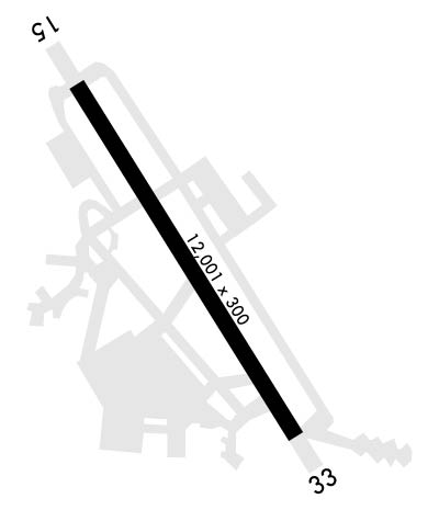
| Lat: N 3238.4 Long: W 08335.5 Elev: 294 Var: +02 Longest Runway: 12001 | ||
| Dept. ATIS: 119.47 Arr. ATIS: 119.47 Ground: 121.85 Tower: 133.22 | ||
| ||||||
|
| Rwy | Rwy | |||||||
| 12001x300 | 12001' | 111.70 - 146° | 12001x300 | 12001' | 110.10 - 326° | |||
| Runway ID | Single Wheel | Double Wheel | Double Tandem Wheel | Dual Double Wheel |
| 15/33 | N/A | N/A | N/A | N/A |
| These numbers are Advisory and are not limits. The Airport Manager should have more accurate Weight Limits | ||||
 Airport Diagram might not be current. | |
| Facility Name: | ROBINS AFB |
| City Name: | WARNER ROBINS |
| County: | HOUSTON |
| State abbrev: | GA |
| State Name: | GEORGIA |
| Ownership: | AIR FORCE OWNED |
| Use: | PRIVATE |
| Owner's Name: | USAF |
| Address: | ROBINS AFB |
| WARNER ROBINS, GA 31093 | |
| Owner's Phone: | |
| Manager's Name: | AIR FIELD MGR/653 RD OSS/OSA |
| Address: | ROBINS AFB;250 EAGLE ST |
| WARNER ROBINS, GA 31098-2602 | |
| Phone: | 478-926-2081 |
| FAA Region: | SOUTHERN |
| FAA Field Office: | ATL |
| Date | Sunrise | Sunset |
|---|---|---|
| 06/07/26 Sunday | 6:26 | 20:40 |
| 06/08/26 Monday | 6:26 | 20:41 |
| 06/09/26 Tuesday | 6:26 | 20:41 |
| 06/10/26 Wednesday | 6:26 | 20:42 |
| 06/11/26 Thursday | 6:26 | 20:42 |
| 06/12/26 Friday | 6:26 | 20:42 |
| 06/13/26 Saturday | 6:26 | 20:43 |
| 06/14/26 Sunday | 6:26 | 20:43 |
| 06/15/26 Monday | 6:26 | 20:43 |
| 06/16/26 Tuesday | 6:26 | 20:44 |
| 06/17/26 Wednesday | 6:26 | 20:44 |
| 06/18/26 Thursday | 6:27 | 20:44 |
| 06/19/26 Friday | 6:27 | 20:45 |
| 06/20/26 Saturday | 6:27 | 20:45 |
| Airport Attendance Schedule | MON-FRI 0500-2300, SAT-SUN & HOLS 0600-2200 |
| Airport Status | OPERATIONAL (This Status can change at any time - please check NOTAMS) |
| Airport Lighting Schedule | |
| Airport Storage Available | NONE |
| Extra Services Available | Cargo Handling |
| Wind Indicator | YES - (unlit) |
| Control Tower | YES |
| CTAF Frequency | |
| Unicom Frequency | |
| Rotating Beacon Color | WG |
| Segmented Circle | NO |
| Landing Fee |
| Airport Inspected | No Inspection Data Available performed by the OWNER |
| Inspection Date | Unknown |
| Type of Fuel Available | ++ |
| Airframe Repair Service | NONE |
| Power Plant Repair Service | MAJOR |
| Latitude | N3238.4 |
| Longitude | W08335.5 (ESTIMATED) |
| Arpt Elevation | 294ft (ESTIMATED) |
| Magnetic Variation | 02W |
| 10 miles SE | of WARNER ROBINS |
| Traffic Pattern Altitude | |
| Sectional Chart | ATLANTA |
| Operations (Reported) | Yearly | Avg. Daily |
|---|---|---|
| General Aviation Transient | 0 | 0 |
| General Aviation Local | 0 | 0 |
| Air Taxi | 0 | 0 |
| Commerical | 0 | 0 |
| Commuter | 0 | 0 |
| Military | 0 | 0 |
| Aircraft based on Field | |
|---|---|
| General Aviation Singles | 0 |
| General Aviation Multi | 0 |
| Jet Aircraft | 0 |
| General Aviation Helicopters | 0 |
| Military Aircraft | 0 |
| Gliders | 0 |
| Ultralights | 0 |
| FSS on field | NO |
| FSS tie-in | MACON |
| FSS Phone | 1-800-WX-BRIEF |
| Who issues Notams | WRB |
| Notam D service at airport | YES |
| ARTCC Name | ATLANTA |
| Airport Certification | |
| Aircraft Rescue & Firefighting Index | None |
| Airport of Entry | No |
| Custom Landing Rights | No |
| Joint Civil/Military | No |
| Military Landing rights | No |
| FLUID: SP PRESAIR LHOX LOX LHNIT |
| OIL: O-148-156- SOAP - AVBL 1200-1900Z++WKD. |
| TRAN ALERT: OPR 1200-0300++ WKD, CLSD SAT, SUN AND HOL. AVBL WKEND FOR HHQ MSNS WITH 24 PN TO AMOPS. TRAN ACFT NOT ALLOWED WHEN TRAN ALERT UNAVBL. FLEET SVC NOT AVBL. DEICING UNAVBL. |
| CSTMS/AG/IMG: CSTMS, AG ON CALL WITH 2 HR PN RQR. US MIL PERS AND DEPENDENTS ONLY. |
| CAUTION: 3 LGT TV TWR 6.5 NM NE 1212 FT. |
| MISC: DEP ACFT DO NOT TURN ON TRANSPONDER TIL ENTERING RWY. ACFT WITH VIP CTC PTD 30 MIN PRIOR WITH FIRM BLOCK TIME. STD USAF RSRS APPLIED. |
| ANG: AMOPS OPR 1330-2130Z++ MON-FRI, EXC HOL, DSN 241-2313, C478-201-2313. |
| RSTD: PPR ALL ACFT, CTC AMOPS DSN 468-2114, C478-926-2114, FAX EXTN 7480. PPR ISSUED UP TO 72 HR PRIOR ARR AND WILL BE GOOD FOR +/- 1 HR. COORD OF PPR OUTSIDE OF BLOCK TIME BY FONE RQR OR WILL BE CONSIDERED CNL. |
| RADAR: SEE TERMINAL FLIP FOR RADAR MINIMA. |
| SERVICE- A-GEAR: BAK-12B- EXTN DISCONNECTED ON APCH END. |
| CAUTION: OBSN VIS RSTD SSW-NNW DUE TO OBST. DEPOT PARKING RAMP FLOODLIGHTS HAMPER NIGHT VIS. APCH END RWY 15 OBST BY BLDG AND ACFT PRK ON DEPOT PARKING RAMP. |
| CAUTION: ON APCH RWY 15, DO NOT MISTAKE MIDDLE GEORGIA RGNL ARPT 3.3 NM NW FOR ROBINS AFB. |
| AMOPS DOES NOT HAVE COMSEC AVBL FOR TRAN CREWS AND HAS NO STORAGE CAP. PRIOR ARNG MUST BE MADE WITH RCP FOR STORAGE OF CLASSIFIED. |
| AMOPS OPR 24 HR. |
| COMMUNICATIONS: AFRC COMD CTR - REMARKS: REQ FONE PATCH FR AFMC COMD POST TO (478) 327-0680. |
| RSTD: RWY 15/33 CLSD FOR PREVENTATIVE MAINTENANCE ON TUES AND THU FR 1000-1300Z++. |
| JASU: 2(A/M-60) 9(A/M323A-86) |
| CAUTION: BIRD WATCH COND-PHASE II FR NOV THRU MAR FR SR-30 TO SR+60 AND SS-30 TO SS+60; DATES ARE SUBJECT TO CHANGE WITH THE MIGRATORY SEASON. SEE NOTAMS FOR UPDATES. |
| NS ABTMT: STRICT ADHERENCE TO PROCEDURE, ACFT RSTD TO FULL STOP ONLY BETWEEN 0300-1100Z++. |
Airport Communications & Frequencies:
| |||||||||||||||||||||||||||
| Runway: 15 | Runway: 33 | ||
| Mag heading: | 146° | Mag heading: | 326° |
| Rwy Slope: | -.17% Down | Rwy Slope: | .17% Up |
| Approach: | ILS | Approach: | ILS |
| Pattern: | Left Traffic | Pattern: | Right Traffic |
| Markings: | Markings: | ||
| Marking Condition: | Marking Condition: | ||
| Arresting Dev: | BAK-14; BAK-14 BAK-12B(B) (1926') | Arresting Dev: | BAK-14; BAK-14 BAK-12B(B) (1651') |
| Lat & Long: | N3239.2 W08336.2 | Lat. & Long.: | N3237.6 W08334.8 |
| Elev: | 292.6 ft. MSL | Elev: | 272.7 ft. MSL |
| TCH: | 55 ft. AGL | TCH: | 55 ft. AGL |
| Visual Glide Path: | 2.70 degrees | Visual Glide Path: | 2.52 degrees |
| Displaced Threshold: | No | Displaced Threshold: | No |
| Touchdown Zone: | YES | Touchdown Zone: | YES |
| Touchdown Elev.: | 293.8 feet | Touchdown Elev.: | 275.0 feet |
| Visual Glide Slope: | 4-Light PAPI on LEFT side of Runway | Visual Glide Slope: | 4-Light PAPI on LEFT side of Runway |
| RVR Equipment: | RVR Equipment: | ||
| RVV Equipment: | NO | RVV Equipment: | NO |
| Approach Lights: | ALSF1 - standard 2,400 foot high intensity approach lighting system with sequenced flashers, Category I | Approach Lights: | ALSF1 - standard 2,400 foot high intensity approach lighting system with sequenced flashers, Category I |
| REIL: | NO | REIL: | NO |
| Centerline Lights: | NO | Centerline Lights: | NO |
| Touchdown lights: | NO | Touchdown lights: | NO |
| Runway Category: | Runway Category: | ||
| Declared Distances: | Declared Distances: |
Thanks for using FltPlan.com
all rights reserved © 1999-2026 by Flight Plan LLC
