
| WHITEMAN LOS ANGELES CA |
| |
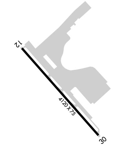
| Lat: N 3415.6 Long: W 11824.8 Elev: 1003 Var: -14 Longest Runway: 4120 | ||
| Dept. ATIS: 132.1 Arr. ATIS: 132.1 AWOS: 132.1 Ground: 125.0 Tower: 135.0 | ||
| ||||||
| ||||||
|
| Rwy | Rwy | |||||||
| 4120x75 | 3391' | 4120x75 | 3642' | |||||
| Runway ID | Single Wheel | Double Wheel | Double Tandem Wheel | Dual Double Wheel |
| 12/30 | 12,500 | N/A | N/A | N/A |
| These numbers are Advisory and are not limits. The Airport Manager should have more accurate Weight Limits | ||||
 Airport Diagram might not be current. | |
| Facility Name: | WHITEMAN |
| City Name: | LOS ANGELES |
| County: | LOS ANGELES |
| State abbrev: | CA |
| State Name: | CALIFORNIA |
| Ownership: | PUBLICLY OWNED |
| Use: | OPEN TO THE PUBLIC |
| Owner's Name: | LOS ANGELES CO |
| Address: | P.O. BOX 1460 |
| ALHAMBRA, CA 91802-1460 | |
| Owner's Phone: | 626-300-4615; LA COUNTY CTC: RICHARD SMITH (626) 300-4600 X4615. AIRPORT MGT CONTRACTED TO - AMERICAN AIRPORTS CORP. |
| Manager's Name: | JIM MILLER; ASSISTANT AMGR: ERNIE UMANA |
| Address: | 10000 AIRPARK WAY |
| PACOIMA, CA 91331 | |
| Phone: | (818) 896-5271; AIR TRAFFIC MGR:- JOEL LATHON - 818-896-5555. |
| FAA Region: | WESTERN-PACIFIC |
| FAA Field Office: | LAX |
| Date | Sunrise | Sunset |
|---|---|---|
| 09/24/21 Friday | 6:43 | 18:48 |
| 09/25/21 Saturday | 6:44 | 18:46 |
| 09/26/21 Sunday | 6:44 | 18:45 |
| 09/27/21 Monday | 6:45 | 18:44 |
| 09/28/21 Tuesday | 6:46 | 18:42 |
| 09/29/21 Wednesday | 6:47 | 18:41 |
| 09/30/21 Thursday | 6:47 | 18:39 |
| 10/01/21 Friday | 6:48 | 18:38 |
| 10/02/21 Saturday | 6:49 | 18:37 |
| 10/03/21 Sunday | 6:50 | 18:35 |
| 10/04/21 Monday | 6:50 | 18:34 |
| 10/05/21 Tuesday | 6:51 | 18:33 |
| 10/06/21 Wednesday | 6:52 | 18:31 |
| 10/07/21 Thursday | 6:53 | 18:30 |
| Airport Attendance Schedule | CONTINUOUS |
| Airport Status | OPERATIONAL (This Status can change at any time - please check NOTAMS) |
| Airport Lighting Schedule | WHEN ATCT CLSD, ARPT LGT OPRS CONSLY. |
| Airport Storage Available | Tie Downs |
| Extra Services Available | Avionics, Charter, Flight Instruction, Aircraft Rental, Aircraft Sales |
| Wind Indicator | YES - (lighted) |
| Control Tower | YES |
| CTAF Frequency | 135.000 |
| Unicom Frequency | 122.950 |
| Rotating Beacon Color | CLEAR-GREEN (Light Land Airport) |
| Segmented Circle | YES |
| Landing Fee |
| Airport Inspected | STATE - performed by STATE AERONAUTICAL PERSONNEL |
| Inspection Date | 03/13/2019 |
| Type of Fuel Available | Grade 100LL, JET A (freeze point -40C) |
| Airframe Repair Service | MAJOR |
| Power Plant Repair Service | MAJOR |
| Latitude | N3415.6 |
| Longitude | W11824.8 (ESTIMATED) |
| Arpt Elevation | 1003ft (ESTIMATED) |
| Magnetic Variation | 14E |
| 1 miles E | of LOS ANGELES |
| Traffic Pattern Altitude | |
| Sectional Chart | LOS ANGELES |
| Operations (Reported) | Yearly | Avg. Daily |
|---|---|---|
| General Aviation Transient | 58423 | 160 |
| General Aviation Local | 57686 | 158 |
| Air Taxi | 0 | 0 |
| Commerical | 0 | 0 |
| Commuter | 0 | 0 |
| Military | 0 | 0 |
| Aircraft based on Field | |
|---|---|
| General Aviation Singles | 213 |
| General Aviation Multi | 12 |
| Jet Aircraft | 0 |
| General Aviation Helicopters | 3 |
| Military Aircraft | 0 |
| Gliders | 2 |
| Ultralights | 0 |
| FSS on field | NO |
| FSS tie-in | HAWTHORNE |
| FSS Phone | 1-800-WX-BRIEF |
| Who issues Notams | WHP |
| Notam D service at airport | YES |
| ARTCC Name | LOS ANGELES |
| Airport Certification | |
| Aircraft Rescue & Firefighting Index | None |
| Airport of Entry | No |
| Custom Landing Rights | No |
| Joint Civil/Military | No |
| Military Landing rights | No |
| NATIONAL PLAN OF INTEGRATED AIRPORT SYSTEMS (NPIAS) |
| GRANT AGREEMENTS UNDER FAAP/ADAP/AIP |
| ASSURANCES PURSUANT TO TITLE VI, CIVIL RIGHTS ACT OF 1964 |
| HELICOPTER OPNS 2500' MSL (1500' AGL) AND BELOW. |
| FOR CD WHEN ATCT CLSD CTC SOCAL APCH AT 800-448-3724. |
| POWER LINES SW OF RY PENETRATE 7:1 TRANSITIONAL SFC. |
| BIRDS ON AND INVOF ARPT. |
| (E125) INCLUDES 3 AMPHIBIANS. |
| AIRPORT CLOSED TO HELICOPTER TRAINING / PATTERN OPERATIONS 2000-0800. |
| DIRT INFIELD AREAS. HELICOPTERS ADVISED TO USE CARE TO PREVENT BLASTING DIRT AND DEBRIS ONTO MOVEMENT AREAS. |
Airport Communications & Frequencies:
| |||||||||||||||||||||||||||||||||||||||
| Runway: 12 | Runway: 30 | ||
| Mag heading: | 125° | Mag heading: | 305° |
| Rwy Slope: | -1.04% Down | Rwy Slope: | 1.04% Up |
| Approach: | Approach: | ||
| Pattern: | Left Traffic | Pattern: | Right Traffic |
| Markings: | BASIC | Markings: | BASIC |
| Marking Condition: | GOOD | Marking Condition: | GOOD |
| Arresting Dev: | Arresting Dev: | ||
| Lat & Long: | N3415.8 W11825.1 | Lat. & Long.: | N3415.3 W11824.5 |
| Elev: | 1003.0 ft. MSL | Elev: | 960.0 ft. MSL |
| TCH: | 54 ft. AGL | TCH: | 26 ft. AGL |
| Visual Glide Path: | 3.80 degrees | Visual Glide Path: | 3.80 degrees |
| Displaced Threshold: | 729 feet | Displaced Threshold: | 478 feet |
| Touchdown Zone: | YES | Touchdown Zone: | YES |
| Touchdown Elev.: | 998.0 feet | Touchdown Elev.: | 998.0 feet |
| Visual Glide Slope: | 2-Light PAPI on RIGHT side of Runway; PAPI DOES NOT PRVD OBSTN CLNC BYD 5 NM FROM THLD. | Visual Glide Slope: | 2-Light PAPI on LEFT side of Runway |
| RVR Equipment: | RVR Equipment: | ||
| RVV Equipment: | NO | RVV Equipment: | NO |
| Approach Lights: | Approach Lights: | ||
| REIL: | YES | REIL: | YES |
| Centerline Lights: | NO | Centerline Lights: | NO |
| Touchdown lights: | NO | Touchdown lights: | NO |
| Runway Category: | Runway with a Visual Approach | Runway Category: | Runway with a Visual Approach |
| Declared Distances: | TORA:3442' TODA:4120' ASDA:3910' LDA:3181' | Declared Distances: | TORA:3191' TODA:4120' ASDA:3940' LDA:3462' |
| Obstructions: | PLINE | Obstructions: | PLINE |
| Marked: | NOT Marked/Lighted | Marked: | LIGHTED |
| Clearance slope: | APCH RATIO 30:1 TO DSPLCD THLD; APCH RATIO TO DSPLCD THLD OVER 33 FT BLDG 850 FT FM DSPLCD THLD 95 FT R 25:1. | Clearance slope: | APCH RATIO 22:1 TO DSPLCD THLD; APCH RATIO TO DSPLCD THLD OVER +35 FT TREE 488 FT FM DSPLCD THLD 110 FT R 13:1. |
| Obstruction height: | 30 feet AGL | Obstruction height: | 30 feet AGL |
| Dist. from runway: | 200 feet | Dist. from runway: | 200 feet |
| Centerline offset: | 45 right of centerline | Centerline offset: | 10 feet right of centerline |
| Comments: | HAS + 6 FT FENCE 60 FT FM EOR AND ROAD 70 FT FM EOR 125 FT L TO R; +12 FT BLDG 135-200 FM FM EOR 20-50 FT L; +24 FT LIGHT STANDARD 140 FT FM EOR 45 FT R. | Comments: | HAS 35 FT TREES 50 FT FM EOR 110 FT R; +6 FT FENCE 30 FT FM EOR 125 FT L TO R; ROAD 80 FT FM EOR 125 FT L TO R; +30 FT PLINES 160 FT FM EOR 125 FT L TO R; + 20 FT LIGHT 75 FT FM EOR 20 FT L. |
Thanks for using FltPlan.com
all rights reserved © 1999-2021 by Flight Plan LLC
