
| PARKER COUNTY WEATHERFORD TX |
| |
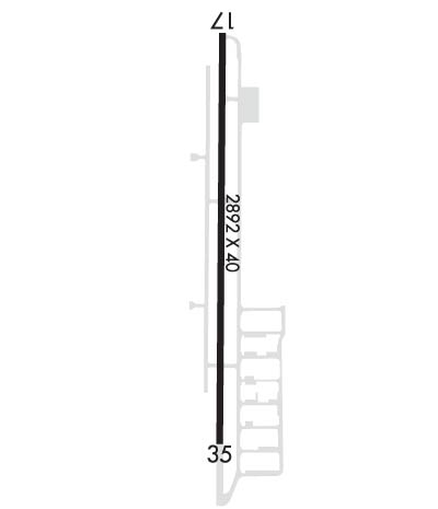
| Lat: N 3244.8 Long: W 09740.9 Elev: 991 Var: -05 Longest Runway: 2892 | ||
| CTAF: 122.7 | ||
| ||||||||||||||||||||||||||||||||||||||||||||
| ||||||||||||||||||||||||||||||||||||||||||||
| Rwy | Rwy | |||||||
| 2892x40 | 2672' | 2892x40 | 2892' | |||||
| Runway ID | Single Wheel | Double Wheel | Double Tandem Wheel | Dual Double Wheel |
| 17/35 | 7,500 | N/A | N/A | N/A |
| These numbers are Advisory and are not limits. The Airport Manager should have more accurate Weight Limits | ||||
 Airport Diagram might not be current. | |
| Facility Name: | PARKER COUNTY |
| City Name: | WEATHERFORD |
| County: | PARKER |
| State abbrev: | TX |
| State Name: | TEXAS |
| Ownership: | PRIVATELY OWNED |
| Use: | OPEN TO THE PUBLIC |
| Owner's Name: | PARKER COUNTY AIRPORT HANGARS ASSOC |
| Address: | 4607 FOREST HILL CIRCLE |
| FORT WORTH, TX 76140 | |
| Owner's Phone: | 817-599-9210 |
| Manager's Name: | BRET PRIVITT |
| Address: | 4607 FOREST HILL CIRCLE |
| FORT WORTH, TX 76140 | |
| Phone: | (817) 822-7205 |
| FAA Region: | SOUTHWEST |
| FAA Field Office: | TEX |
| Date | Sunrise | Sunset |
|---|---|---|
| 09/24/21 Friday | 7:20 | 19:25 |
| 09/25/21 Saturday | 7:21 | 19:24 |
| 09/26/21 Sunday | 7:21 | 19:22 |
| 09/27/21 Monday | 7:22 | 19:21 |
| 09/28/21 Tuesday | 7:23 | 19:20 |
| 09/29/21 Wednesday | 7:23 | 19:18 |
| 09/30/21 Thursday | 7:24 | 19:17 |
| 10/01/21 Friday | 7:25 | 19:16 |
| 10/02/21 Saturday | 7:25 | 19:14 |
| 10/03/21 Sunday | 7:26 | 19:13 |
| 10/04/21 Monday | 7:27 | 19:12 |
| 10/05/21 Tuesday | 7:27 | 19:10 |
| 10/06/21 Wednesday | 7:28 | 19:09 |
| 10/07/21 Thursday | 7:29 | 19:08 |
| Airport Attendance Schedule | 7 Days A Week 0800-1800 |
| Airport Status | OPERATIONAL (This Status can change at any time - please check NOTAMS) |
| Airport Lighting Schedule | SS-SR |
| Airport Storage Available | Tie Downs, Hanger |
| Extra Services Available | NONE |
| Wind Indicator | YES - (lighted) |
| Control Tower | NO |
| CTAF Frequency | 122.700 |
| Unicom Frequency | 122.700 |
| Rotating Beacon Color | |
| Segmented Circle | NO |
| Landing Fee | NO |
| Airport Inspected | STATE - performed by PRIVATE CONTRACT PERSONNEL |
| Inspection Date | 04/19/2019 |
| Type of Fuel Available | Grade 100LL; -10FUEL AVBL 24 HRS SELF SERVE. |
| Airframe Repair Service | None |
| Power Plant Repair Service | None |
| Latitude | N3244.8 |
| Longitude | W09740.9 (ESTIMATED) |
| Arpt Elevation | 991ft (SURVEYED) |
| Magnetic Variation | 05E |
| 5 miles E | of WEATHERFORD |
| Traffic Pattern Altitude | |
| Sectional Chart | DALLAS-FT WORTH |
| Operations (Reported) | Yearly | Avg. Daily |
|---|---|---|
| General Aviation Transient | 12500 | 34 |
| General Aviation Local | 37500 | 103 |
| Air Taxi | 0 | 0 |
| Commerical | 0 | 0 |
| Commuter | 0 | 0 |
| Military | 40 | 0 |
| Aircraft based on Field | |
|---|---|
| General Aviation Singles | 80 |
| General Aviation Multi | 6 |
| Jet Aircraft | 0 |
| General Aviation Helicopters | 0 |
| Military Aircraft | 0 |
| Gliders | 0 |
| Ultralights | 0 |
| FSS on field | NO |
| FSS tie-in | FORT WORTH |
| FSS Phone | 1-800-WX-BRIEF |
| Who issues Notams | FTW |
| Notam D service at airport | YES |
| ARTCC Name | FORT WORTH |
| Airport Certification | |
| Aircraft Rescue & Firefighting Index | None |
| Airport of Entry | No |
| Custom Landing Rights | No |
| Joint Civil/Military | No |
| Military Landing rights | No |
| THIS AIRPORT HAS BEEN SURVEYED BY THE NATIONAL GEODETIC SURVEY. |
| FOR CD CTC REGIONAL APCH AT 972-615-2799. |
| WILDLIFE INVOF APRT. |
| TWY ON WEST SIDE OF RWY CLSD TO PUBLIC INDEFLY. |
| ARPT CLSD TO TRANSIENT STUDENT TFC. |
| CLOSED TO ULTRALIGHT TRAFFIC. |
| RWY 17/3 5 RESTRICTED TO ACFT 7500 LBS OR LESS. |
| RWY 17/3 5 RWY 17/35 NSTD DSPLCD THLD LIGHTS, SINGLE GREEN LIGHT EACH SIDE OF RWY. |
Airport Communications & Frequencies:
| ||||||||||||||
| Runway: 17 | Runway: 35 | ||
| Mag heading: | 175° | Mag heading: | 355° |
| Rwy Slope: | -.21% Down | Rwy Slope: | .21% Up |
| Approach: | Approach: | ||
| Pattern: | Left Traffic | Pattern: | Left Traffic |
| Markings: | BASIC | Markings: | BASIC |
| Marking Condition: | GOOD | Marking Condition: | GOOD |
| Arresting Dev: | Arresting Dev: | ||
| Lat & Long: | N3245.0 W09740.9 | Lat. & Long.: | N3244.5 W09740.9 |
| Elev: | 988.6 ft. MSL | Elev: | 982.6 ft. MSL |
| TCH: | TCH: | ||
| Visual Glide Path: | Visual Glide Path: | ||
| Displaced Threshold: | 220 feet | Displaced Threshold: | No |
| Touchdown Zone: | YES | Touchdown Zone: | YES |
| Touchdown Elev.: | 991.2 feet | Touchdown Elev.: | 991.2 feet |
| Visual Glide Slope: | Visual Glide Slope: | ||
| RVR Equipment: | RVR Equipment: | ||
| RVV Equipment: | NO | RVV Equipment: | NO |
| Approach Lights: | Approach Lights: | ||
| REIL: | NO | REIL: | NO |
| Centerline Lights: | NO | Centerline Lights: | NO |
| Touchdown lights: | NO | Touchdown lights: | NO |
| Runway Category: | Runway with a Visual Approach | Runway Category: | Runway with a Visual Approach |
| Declared Distances: | Declared Distances: | ||
| Obstructions: | TREE | Obstructions: | TREES |
| Marked: | NOT Marked/Lighted | Marked: | NOT Marked/Lighted |
| Clearance slope: | 8:1; APCH RATIO 17:1 FROM DSPLCD THLD; 48 FT TREE 45 FT LEFT 822 FT FM DSPLCD THLD. | Clearance slope: | 4:1; APCH SLOPE 21:1 AT DSPLCD THLD OVR 38 FT TREE 820 FT FM THLD 125 FT R OF CNTRLN. |
| Obstruction height: | 38 feet AGL | Obstruction height: | 40 feet AGL |
| Dist. from runway: | 515 feet | Dist. from runway: | 396 feet |
| Centerline offset: | 55 left of centerline | Centerline offset: | 125 feet right of centerline |
| Comments: | 5 FT FENCE 40 FT FM THLD 120 FT R OF CNTRLN; 20 FT DROP-OFF 10 FT FROM THLD 0B. | Comments: |
Thanks for using FltPlan.com
all rights reserved © 1999-2021 by Flight Plan LLC
