
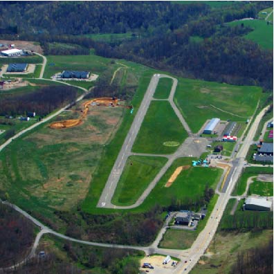
| GREENE COUNTY WAYNESBURG PA |
| |
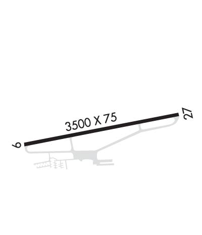
| Lat: N 3954.1 Long: W 08007.8 Elev: 1069 Var: +09 Longest Runway: 3500 | ||
| CTAF: 122.8 | ||
| |||||||||||||||||||||||||||||||||||||||||||||||||||||||||||||
| |||||||||||||||||||||||||||||||||||||||||||||||||||||||||||||
| Rwy | Rwy | |||||||
| 3500x75 | 3500' | 3500x75 | 3500' | |||||
| Runway ID | Single Wheel | Double Wheel | Double Tandem Wheel | Dual Double Wheel |
| 09/27 | 12,000 | N/A | N/A | N/A |
| These numbers are Advisory and are not limits. The Airport Manager should have more accurate Weight Limits | ||||
 Airport Diagram might not be current. | |
| Facility Name: | GREENE COUNTY |
| City Name: | WAYNESBURG |
| County: | GREENE |
| State abbrev: | PA |
| State Name: | PENNSYLVANIA |
| Ownership: | PUBLICLY OWNED |
| Use: | OPEN TO THE PUBLIC |
| Owner's Name: | GREENE COUNTY |
| Address: | COUNTY OFFICE BLDG |
| WAYNESBURG, PA 15370 | |
| Owner's Phone: | 724-852-5323 |
| Manager's Name: | MARIO BARCHIESI |
| Address: | 107 FAIRGROUNDS RD |
| WAYNESBURG, PA 15370 | |
| Phone: | 724-998-5042 |
| FAA Region: | EASTERN |
| FAA Field Office: | HAR |
| Date | Sunrise | Sunset |
|---|---|---|
| 06/08/26 Monday | 5:52 | 20:47 |
| 06/09/26 Tuesday | 5:52 | 20:48 |
| 06/10/26 Wednesday | 5:52 | 20:48 |
| 06/11/26 Thursday | 5:51 | 20:49 |
| 06/12/26 Friday | 5:51 | 20:49 |
| 06/13/26 Saturday | 5:51 | 20:50 |
| 06/14/26 Sunday | 5:51 | 20:50 |
| 06/15/26 Monday | 5:51 | 20:51 |
| 06/16/26 Tuesday | 5:51 | 20:51 |
| 06/17/26 Wednesday | 5:51 | 20:51 |
| 06/18/26 Thursday | 5:52 | 20:52 |
| 06/19/26 Friday | 5:52 | 20:52 |
| 06/20/26 Saturday | 5:52 | 20:52 |
| 06/21/26 Sunday | 5:52 | 20:52 |
| Airport Attendance Schedule | UNATTENDED; FOR SVC AFT HOURS CTC 724-993-2190. |
| Airport Status | OPERATIONAL (This Status can change at any time - please check NOTAMS) |
| Airport Lighting Schedule | |
| Airport Storage Available | Tie Downs, Hanger |
| Extra Services Available | Glider |
| Wind Indicator | YES - (unlit) |
| Control Tower | NO |
| CTAF Frequency | 122.800 |
| Unicom Frequency | 122.800 |
| Rotating Beacon Color | |
| Segmented Circle | YES |
| Landing Fee | NO |
| Airport Inspected | STATE - performed by STATE AERONAUTICAL PERSONNEL |
| Inspection Date | 06/11/2025 |
| Type of Fuel Available | Grade 100LL |
| Airframe Repair Service | MAJOR |
| Power Plant Repair Service | MAJOR |
| Latitude | N3954.1 |
| Longitude | W08007.8 (ESTIMATED) |
| Arpt Elevation | 1068ft (SURVEYED) |
| Magnetic Variation | 09W |
| 2 miles E | of WAYNESBURG |
| Traffic Pattern Altitude | |
| Sectional Chart | CINCINNATI |
| Operations (Reported) | Yearly | Avg. Daily |
|---|---|---|
| General Aviation Transient | 0 | 0 |
| General Aviation Local | 0 | 0 |
| Air Taxi | 0 | 0 |
| Commerical | 0 | 0 |
| Commuter | 0 | 0 |
| Military | 0 | 0 |
| Aircraft based on Field | |
|---|---|
| General Aviation Singles | 0 |
| General Aviation Multi | 0 |
| Jet Aircraft | 0 |
| General Aviation Helicopters | 0 |
| Military Aircraft | 0 |
| Gliders | 0 |
| Ultralights | 0 |
| FSS on field | NO |
| FSS tie-in | ALTOONA |
| FSS Phone | 1-800-WX-BRIEF |
| Who issues Notams | AOO |
| Notam D service at airport | YES |
| ARTCC Name | CLEVELAND |
| Airport Certification | |
| Aircraft Rescue & Firefighting Index | None |
| Airport of Entry | No |
| Custom Landing Rights | No |
| Joint Civil/Military | No |
| Military Landing rights | YES |
| GROUND DROPS OFF SHARPLY EAST END RY 09/27. |
| DEER AND BIRDS ON & INVOF RY. |
| 290 FT HIGH TERRAIN 1,900 FT SOUTH OF RY. |
| FOR CD CTC CLARKSBURG APCH AT 304-842-2011, WHEN APCH CLSD CTC CLEVELAND ARTCC AT 440-774-0226. |
| EXTSV GLIDER OPS WKENDS. |
| DALGT OPNS ONLY. |
| RWY 09 1 RY 09 TWO 10 FT BY 120 FT CONCRETE PATCHES LCTD APPRXLY 570 FT DOWN THE RY ON EACH SIDE OF THE CNTRLN. |
Airport Communications & Frequencies:
| |||||||||||||||||
| Runway: 09 | Runway: 27 | ||
| Mag heading: | N/A | Mag heading: | N/A |
| Rwy Slope: | -.08% Down | Rwy Slope: | .08% Up |
| Approach: | Approach: | ||
| Pattern: | Left Traffic | Pattern: | Left Traffic |
| Markings: | BASIC | Markings: | BASIC |
| Marking Condition: | POOR; RWY NRS AND CL MRKGS IN POOR COND. | Marking Condition: | POOR; RWY NRS AND CL MRKGS IN POOR COND. |
| Arresting Dev: | Arresting Dev: | ||
| Lat & Long: | N3954.0 W08008.2 | Lat. & Long.: | N3954.1 W08007.5 |
| Elev: | 1064.9 ft. MSL | Elev: | 1062.1 ft. MSL |
| TCH: | TCH: | ||
| Visual Glide Path: | Visual Glide Path: | ||
| Displaced Threshold: | No | Displaced Threshold: | No |
| Touchdown Zone: | YES | Touchdown Zone: | YES |
| Touchdown Elev.: | 1068.6 feet | Touchdown Elev.: | 1068.6 feet |
| Visual Glide Slope: | Visual Glide Slope: | ||
| RVR Equipment: | RVR Equipment: | ||
| RVV Equipment: | NO | RVV Equipment: | NO |
| Approach Lights: | Approach Lights: | ||
| REIL: | NO | REIL: | NO |
| Centerline Lights: | NO | Centerline Lights: | NO |
| Touchdown lights: | NO | Touchdown lights: | NO |
| Runway Category: | Runway with a Non-precision Approach | Runway Category: | Runway with a Non-precision Approach |
| Declared Distances: | Declared Distances: | ||
| Obstructions: | TREES | Obstructions: | TREES |
| Marked: | NOT Marked/Lighted | Marked: | NOT Marked/Lighted |
| Clearance slope: | 3:1 | Clearance slope: | 3:1 |
| Obstruction height: | 17 feet AGL | Obstruction height: | 28 feet AGL |
| Dist. from runway: | 257 feet | Dist. from runway: | 285 feet |
| Centerline offset: | 116 left of centerline | Centerline offset: | 84 feet right of centerline |
| Comments: | 15 FT TREES, 128 FT FM RWY END, 166 FT R; 19 FT TREES, 95 FT FM RWY END 180 FT L. | Comments: |
Thanks for using FltPlan.com
all rights reserved © 1999-2026 by Flight Plan LLC
