
| WALLOPS FLIGHT FACILITY WALLOPS ISLAND VA |
| |
| Lat: N 3756.4 Long: W 07528.0 Elev: 40 Var: +11 Longest Runway: 8748 | ||
| Clr Del: 121.7 AWOS: 119.17 Ground: 127.87 Tower: 126.5 | ||
| ||||||
|
| Rwy | Rwy | |||||||
| 8748x150 | 8748' | 8748x150 | 8748' | |||||
| 8005x200 | 8005' | 8005x200 | 8005' | |||||
| 4808x150 | 4808' | 4808x150 | 4808' | |||||
| Runway ID | Single Wheel | Double Wheel | Double Tandem Wheel | Dual Double Wheel |
| 04/22 | 57,000 | 115,000 | 225,000 | N/A |
| 10/28 | 57,000 | 115,000 | 225,000 | N/A |
| 17/35 | 15,000 | 40,000 | 75,000 | N/A |
| These numbers are Advisory and are not limits. The Airport Manager should have more accurate Weight Limits | ||||
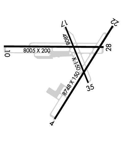 Airport Diagram might not be current. | |
| Facility Name: | WALLOPS FLIGHT FACILITY |
| City Name: | WALLOPS ISLAND |
| County: | ACCOMACK |
| State abbrev: | VA |
| State Name: | VIRGINIA |
| Ownership: | PUBLICLY OWNED |
| Use: | PRIVATE |
| Owner's Name: | NASA |
| Address: | WALLOPS FLIGHT FACILITY |
| WALLOPS ISLAND, VA 23337 | |
| Owner's Phone: | 757-824-1240 |
| Manager's Name: | ED SUDENDORF |
| Address: | WALLOPS FLIGHT FACILITY |
| WALLOPS ISLAND, VA 23337 | |
| Phone: | 757-824-2325 |
| FAA Region: | EASTERN |
| FAA Field Office: | DCA |
| Date | Sunrise | Sunset |
|---|---|---|
| 06/08/26 Monday | 5:39 | 20:23 |
| 06/09/26 Tuesday | 5:39 | 20:23 |
| 06/10/26 Wednesday | 5:39 | 20:24 |
| 06/11/26 Thursday | 5:39 | 20:24 |
| 06/12/26 Friday | 5:39 | 20:25 |
| 06/13/26 Saturday | 5:39 | 20:25 |
| 06/14/26 Sunday | 5:39 | 20:25 |
| 06/15/26 Monday | 5:39 | 20:26 |
| 06/16/26 Tuesday | 5:39 | 20:26 |
| 06/17/26 Wednesday | 5:39 | 20:27 |
| 06/18/26 Thursday | 5:39 | 20:27 |
| 06/19/26 Friday | 5:39 | 20:27 |
| 06/20/26 Saturday | 5:39 | 20:27 |
| 06/21/26 Sunday | 5:40 | 20:28 |
| Airport Attendance Schedule | CONTINUOUS |
| Airport Status | OPERATIONAL (This Status can change at any time - please check NOTAMS) |
| Airport Lighting Schedule | FOR ROTG BCN CALL CTAF. |
| Airport Storage Available | NONE |
| Extra Services Available | NONE |
| Wind Indicator | YES - (lighted) |
| Control Tower | YES |
| CTAF Frequency | 126.500; UHF CTAF - 306.975. |
| Unicom Frequency | |
| Rotating Beacon Color | WG |
| Segmented Circle | NO |
| Landing Fee | NO |
| Airport Inspected | 5010-2 PRIVATE USE MAILOUT PROGRAM - performed by the OWNER |
| Inspection Date | Unknown |
| Type of Fuel Available | JET A (freeze point -40C) |
| Airframe Repair Service | NONE |
| Power Plant Repair Service | NONE |
| Latitude | N3756.4 |
| Longitude | W07528.0 (ESTIMATED) |
| Arpt Elevation | 40ft (SURVEYED) |
| Magnetic Variation | 11W |
| 5 miles S | of WALLOPS ISLAND |
| Traffic Pattern Altitude | |
| Sectional Chart | WASHINGTON |
| Operations (Reported) | Yearly | Avg. Daily |
|---|---|---|
| General Aviation Transient | 0 | 0 |
| General Aviation Local | 0 | 0 |
| Air Taxi | 0 | 0 |
| Commerical | 0 | 0 |
| Commuter | 0 | 0 |
| Military | 0 | 0 |
| Aircraft based on Field | |
|---|---|
| General Aviation Singles | 0 |
| General Aviation Multi | 0 |
| Jet Aircraft | 0 |
| General Aviation Helicopters | 0 |
| Military Aircraft | 0 |
| Gliders | 0 |
| Ultralights | 0 |
| FSS on field | NO |
| FSS tie-in | LEESBURG |
| FSS Phone | 1-800-WX-BRIEF |
| Who issues Notams | WAL |
| Notam D service at airport | YES |
| ARTCC Name | WASHINGTON |
| Airport Certification | |
| Aircraft Rescue & Firefighting Index | None |
| Airport of Entry | No |
| Custom Landing Rights | No |
| Joint Civil/Military | No |
| Military Landing rights | No |
| EXTENSIVE RESEARCH TEST DEVELOPMENT IN PROGRESS. |
| MILITARY TURBOPROP TRAINING DAILY UNTIL 2300L. |
| FCLP EQUIPMENT DIRECTLY ADJACENT TO LEFT SIDE OF RWY 10 1335-1725 FT FM APPROACH END. FCLP EQUIPMENT DIRECTLY ADJACENT TO LEFT SIDE OF RWY 28 1340-1725 FT FM APPROACH END. |
| TOUCH AND GO LDGS NA WHEN ATCT CLSD. |
| RWY 17/35 CLSD WHEN ATCT CLSD. |
| WHEN ATCT CLSD, 126.5 CTAF ONLY. EXPC NO RESP OR ADZY SVCS. |
| E-28 ARRESTING GEAR 1500 FT FM THE NORTH END OF RWY 22 IS RIGGED/IN BATTERY. |
| PPR 24 HR PN TO LDG, PHONE 757-824-1688. |
| FOR CD CTC PATUXENT APCH AT 301-342-3740, WHEN PATUXENT APCH IS CLSD CTC POTOMAC APCH AT 866-640-4124. |
| DEER & BIRDS ON AND INVOF ARPT. |
| NUMEROUS RADAR FACILITIES AT ARPT WITH POSSIBLE RADIO FREQUENCY HAZARD TO ORDNANCE. |
Airport Communications & Frequencies:
| |||||||||||||||||||||||||||||||||
| Runway: 04 | Runway: 22 | ||
| Mag heading: | 43° | Mag heading: | 223° |
| Rwy Slope: | -.03% Down | Rwy Slope: | .03% Up |
| Approach: | Approach: | ||
| Pattern: | Left Traffic | Pattern: | Left Traffic |
| Markings: | NONPRECISION INSTRUMENT | Markings: | NONPRECISION INSTRUMENT |
| Marking Condition: | GOOD | Marking Condition: | GOOD |
| Arresting Dev: | Arresting Dev: | E28; HOOK E28(B) (1500 FT). | |
| Lat & Long: | N3755.6 W07528.3 | Lat. & Long.: | N3756.8 W07527.3 |
| Elev: | 34.0 ft. MSL | Elev: | 31.3 ft. MSL |
| TCH: | 57 ft. AGL | TCH: | 60 ft. AGL |
| Visual Glide Path: | 3.00 degrees | Visual Glide Path: | 3.00 degrees |
| Displaced Threshold: | No | Displaced Threshold: | No |
| Touchdown Zone: | YES | Touchdown Zone: | YES |
| Touchdown Elev.: | 36.7 feet | Touchdown Elev.: | 36.0 feet |
| Visual Glide Slope: | 4-Light PAPI on LEFT side of Runway | Visual Glide Slope: | 4-Light PAPI on LEFT side of Runway |
| RVR Equipment: | RVR Equipment: | ||
| RVV Equipment: | NO | RVV Equipment: | NO |
| Approach Lights: | Approach Lights: | ||
| REIL: | YES | REIL: | YES |
| Centerline Lights: | NO | Centerline Lights: | NO |
| Touchdown lights: | NO | Touchdown lights: | NO |
| Runway Category: | Runway with a Non-precision Approach having visibility minimums greater than 3/4 mile | Runway Category: | Runway with a Non-precision Approach having visibility minimums greater than 3/4 mile |
| Declared Distances: | Declared Distances: | ||
| Obstructions: | Obstructions: | 166 FT HIGH RADAR DISH 800 FT R OF APCH 22. | |
| Marked: | Marked: | NOT Marked/Lighted | |
| Clearance slope: | Clearance slope: | ||
| Obstruction height: | Obstruction height: | ||
| Dist. from runway: | Dist. from runway: | ||
| Centerline offset: | Centerline offset: | ||
| Comments: | Comments: |
| Runway: 10 | Runway: 28 | ||
| Mag heading: | 101° | Mag heading: | 281° |
| Rwy Slope: | .20% Up | Rwy Slope: | -.20% Down |
| Approach: | Approach: | ||
| Pattern: | Left Traffic | Pattern: | Left Traffic |
| Markings: | NONPRECISION INSTRUMENT | Markings: | NONPRECISION INSTRUMENT |
| Marking Condition: | GOOD | Marking Condition: | GOOD |
| Arresting Dev: | Arresting Dev: | ||
| Lat & Long: | N3756.6 W07529.1 | Lat. & Long.: | N3756.6 W07527.4 |
| Elev: | 19.4 ft. MSL | Elev: | 35.2 ft. MSL |
| TCH: | 69 ft. AGL | TCH: | 61 ft. AGL |
| Visual Glide Path: | 3.00 degrees | Visual Glide Path: | 3.00 degrees |
| Displaced Threshold: | No | Displaced Threshold: | No |
| Touchdown Zone: | YES | Touchdown Zone: | YES |
| Touchdown Elev.: | 37.9 feet | Touchdown Elev.: | 40.2 feet |
| Visual Glide Slope: | 4-Light PAPI on LEFT side of Runway | Visual Glide Slope: | 4-Light PAPI on LEFT side of Runway |
| RVR Equipment: | RVR Equipment: | ||
| RVV Equipment: | NO | RVV Equipment: | NO |
| Approach Lights: | Approach Lights: | ||
| REIL: | YES | REIL: | YES |
| Centerline Lights: | NO | Centerline Lights: | NO |
| Touchdown lights: | NO | Touchdown lights: | NO |
| Runway Category: | Runway with a Non-precision Approach having visibility minimums greater than 3/4 mile | Runway Category: | Runway with a Non-precision Approach having visibility minimums greater than 3/4 mile |
| Declared Distances: | Declared Distances: | ||
| Obstructions: | Obstructions: | 510 FT CATV TWR 4 MI OFF APCH RWY 28. | |
| Marked: | Marked: | NOT Marked/Lighted | |
| Clearance slope: | Clearance slope: | ||
| Obstruction height: | Obstruction height: | ||
| Dist. from runway: | Dist. from runway: | ||
| Centerline offset: | Centerline offset: | ||
| Comments: | Comments: |
| Runway: 17 | Runway: 35 | ||
| Mag heading: | 169° | Mag heading: | 349° |
| Rwy Slope: | .08% Up | Rwy Slope: | -.08% Down |
| Approach: | Approach: | ||
| Pattern: | Left Traffic | Pattern: | Left Traffic |
| Markings: | NONPRECISION INSTRUMENT | Markings: | NONPRECISION INSTRUMENT |
| Marking Condition: | FAIR | Marking Condition: | FAIR |
| Arresting Dev: | Arresting Dev: | ||
| Lat & Long: | N3756.8 W07528.1 | Lat. & Long.: | N3756.1 W07527.7 |
| Elev: | 30.7 ft. MSL | Elev: | 34.6 ft. MSL |
| TCH: | 63 ft. AGL | TCH: | 59 ft. AGL |
| Visual Glide Path: | 3.00 degrees | Visual Glide Path: | 3.00 degrees |
| Displaced Threshold: | No | Displaced Threshold: | No |
| Touchdown Zone: | YES | Touchdown Zone: | YES |
| Touchdown Elev.: | 39.2 feet | Touchdown Elev.: | 39.1 feet |
| Visual Glide Slope: | 4-Light PAPI on LEFT side of Runway | Visual Glide Slope: | 4-Light PAPI on LEFT side of Runway |
| RVR Equipment: | RVR Equipment: | ||
| RVV Equipment: | NO | RVV Equipment: | NO |
| Approach Lights: | Approach Lights: | ||
| REIL: | YES | REIL: | YES |
| Centerline Lights: | NO | Centerline Lights: | NO |
| Touchdown lights: | NO | Touchdown lights: | NO |
| Runway Category: | Runway with a Non-precision Approach having visibility minimums greater than 3/4 mile | Runway Category: | Runway with a Non-precision Approach having visibility minimums greater than 3/4 mile |
| Declared Distances: | Declared Distances: |
Thanks for using FltPlan.com
all rights reserved © 1999-2026 by Flight Plan LLC
