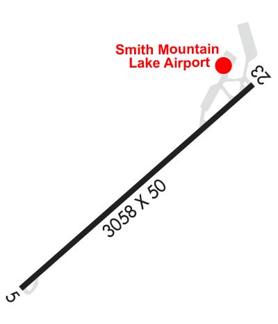
| SMITH MOUNTAIN LAKE MONETA VA |
| |
| Lat: N 3706.5 Long: W 07935.5 Elev: 892 Var: +09 Longest Runway: 3058 | ||
| CTAF: 122.97 | ||
| |||||||||||||||||||||||
| |||||||||||||||||||||||
| Rwy | Rwy | |||||||
| 3058x50 | 2808' | 3058x50 | 3058' | |||||
| Runway ID | Single Wheel | Double Wheel | Double Tandem Wheel | Dual Double Wheel |
| 05/23 | N/A | N/A | N/A | N/A |
| These numbers are Advisory and are not limits. The Airport Manager should have more accurate Weight Limits | ||||
 Airport Diagram might not be current. | |
| Facility Name: | SMITH MOUNTAIN LAKE |
| City Name: | MONETA |
| County: | BEDFORD |
| State abbrev: | VA |
| State Name: | VIRGINIA |
| Ownership: | PRIVATELY OWNED |
| Use: | OPEN TO THE PUBLIC |
| Owner's Name: | SMITH MOUNTAIN LAKE AIRPORT, LLC. |
| Address: | 1090 CUTLASS RD |
| MONETA, VA 24121 | |
| Owner's Phone: | 540-297-4859 |
| Manager's Name: | MOE BAZAZAN |
| Address: | 1090 CUTLASS RD |
| MONETA, VA 24121 | |
| Phone: | 540-297-4859 |
| FAA Region: | EASTERN |
| FAA Field Office: | DCA |
| Date | Sunrise | Sunset |
|---|---|---|
| 09/24/21 Friday | 7:08 | 19:13 |
| 09/25/21 Saturday | 7:08 | 19:11 |
| 09/26/21 Sunday | 7:09 | 19:10 |
| 09/27/21 Monday | 7:10 | 19:08 |
| 09/28/21 Tuesday | 7:11 | 19:07 |
| 09/29/21 Wednesday | 7:12 | 19:05 |
| 09/30/21 Thursday | 7:13 | 19:04 |
| 10/01/21 Friday | 7:14 | 19:02 |
| 10/02/21 Saturday | 7:14 | 19:01 |
| 10/03/21 Sunday | 7:15 | 18:59 |
| 10/04/21 Monday | 7:16 | 18:58 |
| 10/05/21 Tuesday | 7:17 | 18:56 |
| 10/06/21 Wednesday | 7:18 | 18:55 |
| 10/07/21 Thursday | 7:19 | 18:53 |
| Airport Attendance Schedule | CONTINUOUS |
| Airport Status | OPERATIONAL (This Status can change at any time - please check NOTAMS) |
| Airport Lighting Schedule | |
| Airport Storage Available | Tie Downs |
| Extra Services Available | Flight Instruction, Aircraft Rental, Aircraft Sales |
| Wind Indicator | YES - (unlit) |
| Control Tower | NO |
| CTAF Frequency | 122.975 |
| Unicom Frequency | 122.975 |
| Rotating Beacon Color | CLEAR-GREEN (Light Land Airport) |
| Segmented Circle | NO |
| Landing Fee |
| Airport Inspected | STATE - performed by STATE AERONAUTICAL PERSONNEL |
| Inspection Date | 08/27/2020 |
| Type of Fuel Available | Grade 100LL; -1024-HR SELF-SERVE FUEL AVAILABLE WITH CREDIT CARD. |
| Airframe Repair Service | MAJOR |
| Power Plant Repair Service | MAJOR |
| Latitude | N3706.5 |
| Longitude | W07935.5 (ESTIMATED) |
| Arpt Elevation | 892ft (SURVEYED) |
| Magnetic Variation | 09W |
| 4 miles SE | of MONETA |
| Traffic Pattern Altitude | |
| Sectional Chart | CINCINNATI |
| Operations (Reported) | Yearly | Avg. Daily |
|---|---|---|
| General Aviation Transient | 1223 | 3 |
| General Aviation Local | 3886 | 11 |
| Air Taxi | 22 | 0 |
| Commerical | 0 | 0 |
| Commuter | 0 | 0 |
| Military | 10 | 0 |
| Aircraft based on Field | |
|---|---|
| General Aviation Singles | 28 |
| General Aviation Multi | 1 |
| Jet Aircraft | 0 |
| General Aviation Helicopters | 0 |
| Military Aircraft | 0 |
| Gliders | 0 |
| Ultralights | 0 |
| FSS on field | NO |
| FSS tie-in | LEESBURG |
| FSS Phone | 1-800-WX-BRIEF |
| Who issues Notams | DCA |
| Notam D service at airport | YES |
| ARTCC Name | WASHINGTON |
| Airport Certification | |
| Aircraft Rescue & Firefighting Index | None |
| Airport of Entry | No |
| Custom Landing Rights | No |
| Joint Civil/Military | No |
| Military Landing rights | No |
| DEER ON & INVOF ARPT. |
| ROA TWR SVCS AVBL AT 540-563-1307. |
| LNDG FEE FOR ALL ACFT OVR 5500 LBS. |
| CLSD TO TRANSIENT PRACTICE LANDINGS. CLSD TO TRANSIENT ACFT PERFORMING TGL AND PLA. |
Airport Communications & Frequencies:
| ||||||||||||||
| Runway: 05 | Runway: 23 | ||
| Mag heading: | 54° | Mag heading: | 234° |
| Rwy Slope: | 1.22% Up | Rwy Slope: | -1.22% Down |
| Approach: | Approach: | ||
| Pattern: | Left Traffic | Pattern: | Left Traffic |
| Markings: | BASIC | Markings: | NONPRECISION INSTRUMENT |
| Marking Condition: | GOOD | Marking Condition: | GOOD |
| Arresting Dev: | Arresting Dev: | ||
| Lat & Long: | N3706.3 W07935.8 | Lat. & Long.: | N3706.6 W07935.3 |
| Elev: | 854.7 ft. MSL | Elev: | 892.0 ft. MSL |
| TCH: | TCH: | ||
| Visual Glide Path: | Visual Glide Path: | ||
| Displaced Threshold: | 250 feet | Displaced Threshold: | No |
| Touchdown Zone: | YES | Touchdown Zone: | YES |
| Touchdown Elev.: | 892.2 feet | Touchdown Elev.: | 892.2 feet |
| Visual Glide Slope: | Visual Glide Slope: | ||
| RVR Equipment: | RVR Equipment: | ||
| RVV Equipment: | NO | RVV Equipment: | NO |
| Approach Lights: | Approach Lights: | ||
| REIL: | NO | REIL: | YES; REIL OTS INDEFLY. |
| Centerline Lights: | NO | Centerline Lights: | NO |
| Touchdown lights: | NO | Touchdown lights: | NO |
| Runway Category: | Runway with a Visual Approach | Runway Category: | Runway with a Non-precision Approach |
| Declared Distances: | Declared Distances: | ||
| Obstructions: | TREES | Obstructions: | TREE |
| Marked: | NOT Marked/Lighted | Marked: | NOT Marked/Lighted |
| Clearance slope: | 3:1; APCH SLOPE 9:1 TO DSPLCD THR BASED | Clearance slope: | 2:1 |
| Obstruction height: | 46 feet AGL | Obstruction height: | 15 feet AGL |
| Dist. from runway: | 382 feet | Dist. from runway: | 238 feet |
| Centerline offset: | 93 right of centerline | Centerline offset: | 122 feet left of centerline |
| Comments: | RY 05 HAS +12 FT ROAD AT THLD 100 FT R. PWR POLE 128 FT RIGHT OF APCH 86 FT FM THLD. | Comments: |
Thanks for using FltPlan.com
all rights reserved © 1999-2021 by Flight Plan LLC