
| NEW LONDON FOREST VA |
| |
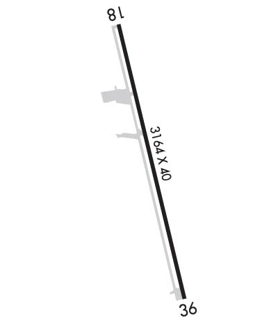
| Lat: N 3716.3 Long: W 07920.2 Elev: 842 Var: +09 Longest Runway: 3164 | ||
| CTAF: 122.8 | ||
| ||||||||||||||||||||||||||||||||||||||||||||
| ||||||||||||||||||||||||||||||||||||||||||||
| Rwy | Rwy | |||||||
| 3164x40 | 3049' | 3164x40 | 3164' | |||||
| Runway ID | Single Wheel | Double Wheel | Double Tandem Wheel | Dual Double Wheel |
| 18/36 | N/A | N/A | N/A | N/A |
| These numbers are Advisory and are not limits. The Airport Manager should have more accurate Weight Limits | ||||
 Airport Diagram might not be current. | |
| Facility Name: | NEW LONDON |
| City Name: | FOREST |
| County: | BEDFORD |
| State abbrev: | VA |
| State Name: | VIRGINIA |
| Ownership: | PRIVATELY OWNED |
| Use: | OPEN TO THE PUBLIC |
| Owner's Name: | LIBERTY UNIVERSITY, INC. |
| Address: | 1971 UNIVERSITY BLVD |
| LYNCHBURG, VA 24515 | |
| Owner's Phone: | |
| Manager's Name: | JOSEPH WALLACE |
| Address: | 310 HANGAR RD |
| LYNCHBURG, VA 24502 | |
| Phone: | 434-582-3028 |
| FAA Region: | EASTERN |
| FAA Field Office: | DCA |
| Date | Sunrise | Sunset |
|---|---|---|
| 09/24/21 Friday | 7:07 | 19:12 |
| 09/25/21 Saturday | 7:07 | 19:10 |
| 09/26/21 Sunday | 7:08 | 19:09 |
| 09/27/21 Monday | 7:09 | 19:07 |
| 09/28/21 Tuesday | 7:10 | 19:05 |
| 09/29/21 Wednesday | 7:11 | 19:04 |
| 09/30/21 Thursday | 7:12 | 19:02 |
| 10/01/21 Friday | 7:13 | 19:01 |
| 10/02/21 Saturday | 7:13 | 18:59 |
| 10/03/21 Sunday | 7:14 | 18:58 |
| 10/04/21 Monday | 7:15 | 18:56 |
| 10/05/21 Tuesday | 7:16 | 18:55 |
| 10/06/21 Wednesday | 7:17 | 18:54 |
| 10/07/21 Thursday | 7:18 | 18:52 |
| Airport Attendance Schedule | UNATTENDED |
| Airport Status | OPERATIONAL (This Status can change at any time - please check NOTAMS) |
| Airport Lighting Schedule | |
| Airport Storage Available | Tie Downs |
| Extra Services Available | Crop Dusting, Flight Instruction |
| Wind Indicator | YES - (unlit) |
| Control Tower | NO |
| CTAF Frequency | 122.800 |
| Unicom Frequency | 122.800 |
| Rotating Beacon Color | |
| Segmented Circle | NO |
| Landing Fee | NO |
| Airport Inspected | STATE - performed by STATE AERONAUTICAL PERSONNEL |
| Inspection Date | 08/09/2018 |
| Type of Fuel Available | None |
| Airframe Repair Service | NONE |
| Power Plant Repair Service | NONE |
| Latitude | N3716.3 |
| Longitude | W07920.2 (ESTIMATED) |
| Arpt Elevation | 842ft (SURVEYED) |
| Magnetic Variation | 09W |
| 6 miles SW | of FOREST |
| Traffic Pattern Altitude | |
| Sectional Chart | CINCINNATI |
| Operations (Reported) | Yearly | Avg. Daily |
|---|---|---|
| General Aviation Transient | 6188 | 17 |
| General Aviation Local | 25990 | 71 |
| Air Taxi | 0 | 0 |
| Commerical | 0 | 0 |
| Commuter | 0 | 0 |
| Military | 583 | 2 |
| Aircraft based on Field | |
|---|---|
| General Aviation Singles | 41 |
| General Aviation Multi | 1 |
| Jet Aircraft | 0 |
| General Aviation Helicopters | 0 |
| Military Aircraft | 0 |
| Gliders | 0 |
| Ultralights | 1 |
| FSS on field | NO |
| FSS tie-in | LEESBURG |
| FSS Phone | 1-800-WX-BRIEF |
| Who issues Notams | DCA |
| Notam D service at airport | YES |
| ARTCC Name | WASHINGTON |
| Airport Certification | |
| Aircraft Rescue & Firefighting Index | None |
| Airport of Entry | No |
| Custom Landing Rights | No |
| Joint Civil/Military | No |
| Military Landing rights | No |
| STAND, FENCE & TOWER IN PRIM AND/OR TRNSL SFCS WITH GUARDRAIL BOTH SIDES OF RY 36. |
| RY USED AS DRAG STRIP ON CERTAIN SUNDAYS SUMMER MONTHS. NOTAMED WHEN AIRPORT CLOSED. |
| ULTRA LGT ACFT ON & INVOF ARPT. |
| ROA TWR SVCS AVBL AT 540-563-1307. |
| FOR CD CTC ROANOKE APCH AT 540-563-1307. |
| RWY 18/3 6 RWY 18/36 CLSD DAILY SS-SR. |
Airport Communications & Frequencies:
| ||||||||||||||
| Runway: 18 | Runway: 36 | ||
| Mag heading: | N/A | Mag heading: | N/A |
| Rwy Slope: | -2.28% Down | Rwy Slope: | 2.28% Up |
| Approach: | Approach: | ||
| Pattern: | Left Traffic | Pattern: | Left Traffic |
| Markings: | BASIC | Markings: | BASIC |
| Marking Condition: | FAIR | Marking Condition: | FAIR |
| Arresting Dev: | Arresting Dev: | ||
| Lat & Long: | N3716.6 W07920.2 | Lat. & Long.: | N3716.1 W07920.1 |
| Elev: | 842.0 ft. MSL | Elev: | 770.0 ft. MSL |
| TCH: | TCH: | ||
| Visual Glide Path: | Visual Glide Path: | ||
| Displaced Threshold: | 115 feet | Displaced Threshold: | No |
| Touchdown Zone: | YES | Touchdown Zone: | YES |
| Touchdown Elev.: | 842.0 feet | Touchdown Elev.: | 831.0 feet |
| Visual Glide Slope: | Visual Glide Slope: | ||
| RVR Equipment: | RVR Equipment: | ||
| RVV Equipment: | NO | RVV Equipment: | NO |
| Approach Lights: | Approach Lights: | ||
| REIL: | NO | REIL: | NO |
| Centerline Lights: | NO | Centerline Lights: | NO |
| Touchdown lights: | NO | Touchdown lights: | NO |
| Runway Category: | Runway with a Visual Approach | Runway Category: | Runway with a Visual Approach |
| Declared Distances: | Declared Distances: | ||
| Obstructions: | GND | Obstructions: | TREES |
| Marked: | NOT Marked/Lighted | Marked: | NOT Marked/Lighted |
| Clearance slope: | 1:1; APCH RATIO 8:1 TO DSPLCD THLD. | Clearance slope: | 17:1 |
| Obstruction height: | 10 feet AGL | Obstruction height: | 123 feet AGL |
| Dist. from runway: | 200 feet | Dist. from runway: | 2389 feet |
| Centerline offset: | 120 right of centerline | Centerline offset: | 230 feet right of centerline |
| Comments: | +26 FT ROAD 100 FT FM RY END 110 FT R CROSSING EXTDD CNTRLN; +4 FT GND 0-100 FT FM THLD 110-125 FT R; 37 FT TREE 131 FT FM RY END 118 R. | Comments: |
Thanks for using FltPlan.com
all rights reserved © 1999-2021 by Flight Plan LLC
