| WILLIAM M TUCK SOUTH BOSTON VA |
| |
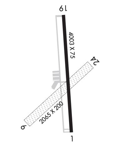
| Lat: N 3642.6 Long: W 07850.9 Elev: 420 Var: +08 Longest Runway: 4003 | ||
| AWOS: 119.42 CTAF: 122.8 | ||
| |||||||||||||||||||||||||||||||||||||||||||||||||||||||||||||
| |||||||||||||||||||||||||||||||||||||||||||||||||||||||||||||
| |||||||||||||||||||||||||||||||||||||||||||||||||||||||||||||
| Rwy | Rwy | |||||||
| 4003x75 | 4003' | 4003x75 | 4003' | |||||
| 2065x200 | 2065' | 2065x200 | 2065' | |||||
| Runway ID | Single Wheel | Double Wheel | Double Tandem Wheel | Dual Double Wheel |
| 01/19 | 12,500 | N/A | N/A | N/A |
| 06/24 | N/A | N/A | N/A | N/A |
| These numbers are Advisory and are not limits. The Airport Manager should have more accurate Weight Limits | ||||
 Airport Diagram might not be current. | |
| Facility Name: | WILLIAM M TUCK |
| City Name: | SOUTH BOSTON |
| County: | HALIFAX |
| State abbrev: | VA |
| State Name: | VIRGINIA |
| Ownership: | PUBLICLY OWNED |
| Use: | OPEN TO THE PUBLIC |
| Owner's Name: | COUNTY OF HALIFAX |
| Address: | PO BOX 699 |
| HALIFAX, VA 24558 | |
| Owner's Phone: | 434-476-3300 |
| Manager's Name: | OTIS VAUGHAN |
| Address: | PO BOX 699 |
| HALIFAX, VA 24558 | |
| Phone: | 434-476-3300 |
| FAA Region: | EASTERN |
| FAA Field Office: | DCA |
| Date | Sunrise | Sunset |
|---|---|---|
| 09/24/21 Friday | 7:05 | 19:10 |
| 09/25/21 Saturday | 7:05 | 19:08 |
| 09/26/21 Sunday | 7:06 | 19:07 |
| 09/27/21 Monday | 7:07 | 19:05 |
| 09/28/21 Tuesday | 7:08 | 19:04 |
| 09/29/21 Wednesday | 7:09 | 19:02 |
| 09/30/21 Thursday | 7:10 | 19:01 |
| 10/01/21 Friday | 7:10 | 18:59 |
| 10/02/21 Saturday | 7:11 | 18:58 |
| 10/03/21 Sunday | 7:12 | 18:56 |
| 10/04/21 Monday | 7:13 | 18:55 |
| 10/05/21 Tuesday | 7:14 | 18:53 |
| 10/06/21 Wednesday | 7:15 | 18:52 |
| 10/07/21 Thursday | 7:16 | 18:50 |
| Airport Attendance Schedule | UNATTENDED |
| Airport Status | OPERATIONAL (This Status can change at any time - please check NOTAMS) |
| Airport Lighting Schedule | ACTVT MIRL RY 01/19 & REIL RYS 01 & 19 - CTAF. PAPI RYS 01 & 19 OPER CONT. |
| Airport Storage Available | Tie Downs |
| Extra Services Available | Flight Instruction |
| Wind Indicator | YES - (lighted) |
| Control Tower | NO |
| CTAF Frequency | 122.800 |
| Unicom Frequency | 122.800 |
| Rotating Beacon Color | CLEAR-GREEN (Light Land Airport) |
| Segmented Circle | NO |
| Landing Fee | NO |
| Airport Inspected | STATE - performed by STATE AERONAUTICAL PERSONNEL |
| Inspection Date | 08/13/2020 |
| Type of Fuel Available | Grade 100LL |
| Airframe Repair Service | NONE |
| Power Plant Repair Service | NONE |
| Latitude | N3642.6 |
| Longitude | W07850.9 (ESTIMATED) |
| Arpt Elevation | 419ft (SURVEYED) |
| Magnetic Variation | 08W |
| 3 miles E | of SOUTH BOSTON |
| Traffic Pattern Altitude | 800 |
| Sectional Chart | WASHINGTON |
| Operations (Reported) | Yearly | Avg. Daily |
|---|---|---|
| General Aviation Transient | 2520 | 7 |
| General Aviation Local | 4831 | 13 |
| Air Taxi | 0 | 0 |
| Commerical | 0 | 0 |
| Commuter | 0 | 0 |
| Military | 0 | 0 |
| Aircraft based on Field | |
|---|---|
| General Aviation Singles | 14 |
| General Aviation Multi | 0 |
| Jet Aircraft | 0 |
| General Aviation Helicopters | 2 |
| Military Aircraft | 0 |
| Gliders | 0 |
| Ultralights | 0 |
| FSS on field | NO |
| FSS tie-in | LEESBURG |
| FSS Phone | 1-800-WX-BRIEF |
| Who issues Notams | DCA |
| Notam D service at airport | YES |
| ARTCC Name | WASHINGTON |
| Airport Certification | |
| Aircraft Rescue & Firefighting Index | None |
| Airport of Entry | No |
| Custom Landing Rights | No |
| Joint Civil/Military | No |
| Military Landing rights | YES |
| NATIONAL PLAN OF INTEGRATED AIRPORT SYSTEMS (NPIAS) |
| GRANT AGREEMENTS UNDER FAAP/ADAP/AIP |
| WILDLIFE ON & INVOF RYS. |
| SELF-FUELING WITH A CREDIT CARD. |
| RWY 06/24 CLSD TO ACFT WITH AIRSPEED 50 KT OR MORE. |
| FOR CD CTC WASHINGTON ARTCC AT 703-771-3587. |
Airport Communications & Frequencies:
| |||||||||
| Runway: 01 | Runway: 19 | ||
| Mag heading: | 5° | Mag heading: | 185° |
| Rwy Slope: | .93% Up | Rwy Slope: | -.93% Down |
| Approach: | Approach: | ||
| Pattern: | Left Traffic | Pattern: | Left Traffic |
| Markings: | NONPRECISION INSTRUMENT | Markings: | NONPRECISION INSTRUMENT |
| Marking Condition: | GOOD | Marking Condition: | GOOD |
| Arresting Dev: | Arresting Dev: | ||
| Lat & Long: | N3642.3 W07850.9 | Lat. & Long.: | N3642.9 W07850.9 |
| Elev: | 382.5 ft. MSL | Elev: | 419.8 ft. MSL |
| TCH: | 59 ft. AGL | TCH: | 41 ft. AGL |
| Visual Glide Path: | 3.00 degrees | Visual Glide Path: | 3.00 degrees |
| Displaced Threshold: | No | Displaced Threshold: | No |
| Touchdown Zone: | YES | Touchdown Zone: | YES |
| Touchdown Elev.: | 409.8 feet | Touchdown Elev.: | 419.8 feet |
| Visual Glide Slope: | 2-Light PAPI on LEFT side of Runway | Visual Glide Slope: | 2-Light PAPI on LEFT side of Runway |
| RVR Equipment: | RVR Equipment: | ||
| RVV Equipment: | NO | RVV Equipment: | NO |
| Approach Lights: | Approach Lights: | ||
| REIL: | YES | REIL: | YES |
| Centerline Lights: | NO | Centerline Lights: | NO |
| Touchdown lights: | NO | Touchdown lights: | NO |
| Runway Category: | Runway with a Non-precision Approach | Runway Category: | Runway with a Visual Approach |
| Declared Distances: | Declared Distances: | ||
| Obstructions: | BRUSH | Obstructions: | TREE |
| Marked: | NOT Marked/Lighted | Marked: | NOT Marked/Lighted |
| Clearance slope: | 16:1 | Clearance slope: | 25:1 |
| Obstruction height: | 41 feet AGL | Obstruction height: | 47 feet AGL |
| Dist. from runway: | 880 feet | Dist. from runway: | 1383 feet |
| Centerline offset: | 262 right of centerline | Centerline offset: | 242 feet left of centerline |
| Comments: | Comments: |
| Runway: 06 | Runway: 24 | ||
| Mag heading: | 56° | Mag heading: | 236° |
| Rwy Slope: | .69% Up | Rwy Slope: | -.69% Down |
| Approach: | Approach: | ||
| Pattern: | Left Traffic | Pattern: | Left Traffic |
| Markings: | Markings: | ||
| Marking Condition: | RY 06 OUTLINED WITH YELLOW CONES. | Marking Condition: | RY 24 OUTLINED WITH YELLOW CONES. |
| Arresting Dev: | Arresting Dev: | ||
| Lat & Long: | N3642.4 W07851.1 | Lat. & Long.: | N3642.6 W07850.8 |
| Elev: | 375.6 ft. MSL | Elev: | 389.8 ft. MSL |
| TCH: | TCH: | ||
| Visual Glide Path: | Visual Glide Path: | ||
| Displaced Threshold: | No | Displaced Threshold: | No |
| Touchdown Zone: | YES | Touchdown Zone: | YES |
| Touchdown Elev.: | 391.2 feet | Touchdown Elev.: | 391.2 feet |
| Visual Glide Slope: | Visual Glide Slope: | ||
| RVR Equipment: | RVR Equipment: | ||
| RVV Equipment: | NO | RVV Equipment: | NO |
| Approach Lights: | Approach Lights: | ||
| REIL: | NO | REIL: | NO |
| Centerline Lights: | NO | Centerline Lights: | NO |
| Touchdown lights: | NO | Touchdown lights: | NO |
| Runway Category: | Runway with a Visual Approach | Runway Category: | Runway with a Visual Approach |
| Declared Distances: | Declared Distances: | ||
| Obstructions: | TREES | Obstructions: | TREES |
| Marked: | NOT Marked/Lighted | Marked: | NOT Marked/Lighted |
| Clearance slope: | 13:1 | Clearance slope: | 9:1 |
| Obstruction height: | 69 feet AGL | Obstruction height: | 70 feet AGL |
| Dist. from runway: | 1134 feet | Dist. from runway: | 891 feet |
| Centerline offset: | 143 right of centerline | Centerline offset: | 70 feet right of centerline |
| Comments: | Comments: |
Thanks for using FltPlan.com
all rights reserved © 1999-2021 by Flight Plan LLC