
| HUMMEL FIELD SALUDA VA |
| |
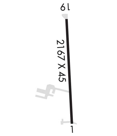
| Lat: N 3736.1 Long: W 07626.8 Elev: 30 Var: +10 Longest Runway: 2167 | ||
| AWOS: 118.45 CTAF: 123.0 | ||
| ||||||||||||||||||||||||||||||||||||||||||||
| ||||||||||||||||||||||||||||||||||||||||||||
| ||||||||||||||||||||||||||||||||||||||||||||
| Rwy | Rwy | |||||||
| 2167x45 | 2042' | 2167x45 | 2167' | |||||
| Runway ID | Single Wheel | Double Wheel | Double Tandem Wheel | Dual Double Wheel |
| 01/19 | 12,500 | N/A | N/A | N/A |
| These numbers are Advisory and are not limits. The Airport Manager should have more accurate Weight Limits | ||||
 Airport Diagram might not be current. | |
| Facility Name: | HUMMEL FLD |
| City Name: | SALUDA; TOPPING IS THE CITY CLOSEST TO THE APT. APT IS 2 MILES ENE. |
| County: | MIDDLESEX |
| State abbrev: | VA |
| State Name: | VIRGINIA |
| Ownership: | PUBLICLY OWNED |
| Use: | OPEN TO THE PUBLIC |
| Owner's Name: | COUNTY BOARD OF SUPERVISORS |
| Address: | 877 GENERAL PULLER HWY, P.O. BOX 428 |
| SALUDA, VA 23149 | |
| Owner's Phone: | 804-758-4330 |
| Manager's Name: | BETTY MUNCY; APT PHYSICAL ADDRESS IS: 310 PLANEVIEW ROAD TOPPING, VA 23169 |
| Address: | 877 GENERAL PULLER HWY, P.O. BOX 428 |
| SALUDA, VA 23149 | |
| Phone: | 804-758-4330 |
| FAA Region: | EASTERN |
| FAA Field Office: | DCA |
| Date | Sunrise | Sunset |
|---|---|---|
| 09/24/21 Friday | 6:55 | 19:00 |
| 09/25/21 Saturday | 6:56 | 18:58 |
| 09/26/21 Sunday | 6:57 | 18:57 |
| 09/27/21 Monday | 6:58 | 18:55 |
| 09/28/21 Tuesday | 6:58 | 18:54 |
| 09/29/21 Wednesday | 6:59 | 18:52 |
| 09/30/21 Thursday | 7:00 | 18:51 |
| 10/01/21 Friday | 7:01 | 18:49 |
| 10/02/21 Saturday | 7:02 | 18:48 |
| 10/03/21 Sunday | 7:03 | 18:46 |
| 10/04/21 Monday | 7:04 | 18:45 |
| 10/05/21 Tuesday | 7:05 | 18:43 |
| 10/06/21 Wednesday | 7:05 | 18:42 |
| 10/07/21 Thursday | 7:06 | 18:40 |
| Airport Attendance Schedule | 7 Days A Week 0800-1600; UNATNDD THANKSGIVING, CHRISTMAS DAY AND NEW YEAR'S. |
| Airport Status | OPERATIONAL (This Status can change at any time - please check NOTAMS) |
| Airport Lighting Schedule | ACTVT MIRL RY 01/19 - CTAF. |
| Airport Storage Available | Tie Downs |
| Extra Services Available | Crop Dusting, Flight Instruction, Aircraft Rental |
| Wind Indicator | YES - (lighted) |
| Control Tower | NO |
| CTAF Frequency | 123.000 |
| Unicom Frequency | 123.000 |
| Rotating Beacon Color | CLEAR-GREEN (Light Land Airport) |
| Segmented Circle | NO |
| Landing Fee |
| Airport Inspected | STATE - performed by STATE AERONAUTICAL PERSONNEL |
| Inspection Date | 10/22/2020 |
| Type of Fuel Available | Grade 100LL |
| Airframe Repair Service | MAJOR |
| Power Plant Repair Service | MAJOR |
| Latitude | N3736.1 |
| Longitude | W07626.8 (ESTIMATED) |
| Arpt Elevation | 30ft (SURVEYED) |
| Magnetic Variation | 10W |
| 6 miles E | of SALUDA; TOPPING IS THE CITY CLOSEST TO THE APT. APT IS 2 MILES ENE. |
| Traffic Pattern Altitude | |
| Sectional Chart | WASHINGTON |
| Operations (Reported) | Yearly | Avg. Daily |
|---|---|---|
| General Aviation Transient | 956 | 3 |
| General Aviation Local | 11597 | 32 |
| Air Taxi | 0 | 0 |
| Commerical | 0 | 0 |
| Commuter | 0 | 0 |
| Military | 282 | 1 |
| Aircraft based on Field | |
|---|---|
| General Aviation Singles | 31 |
| General Aviation Multi | 1 |
| Jet Aircraft | 0 |
| General Aviation Helicopters | 0 |
| Military Aircraft | 0 |
| Gliders | 0 |
| Ultralights | 0 |
| FSS on field | NO |
| FSS tie-in | LEESBURG |
| FSS Phone | 1-800-WX-BRIEF |
| Who issues Notams | DCA |
| Notam D service at airport | YES |
| ARTCC Name | WASHINGTON |
| Airport Certification | |
| Aircraft Rescue & Firefighting Index | None |
| Airport of Entry | No |
| Custom Landing Rights | No |
| Joint Civil/Military | No |
| Military Landing rights | No |
| DRAINAGE SWALES FULL LENGTH OF RY ON BOTH SIDES; USE OF EXIT IN FRONT OF HUMMEL AVIATION ADVISED. |
| DEPARTING RY 18/36 CLIMB TO 500 FT BEFORE ANY TURN OUT; ARRIVING ACFT USE WIDE PAT TO AVOID POPULATED AREAS EAST & WEST OF ARPT. |
| BIRDS AND DEER ON & INVOF ARPT DURING WINTER. |
| FOR CD CTC NORFOLK APCH AT 757-464-0757. |
Airport Communications & Frequencies:
| ||||||||||||||
| Runway: 01 | Runway: 19 | ||
| Mag heading: | 6° | Mag heading: | 186° |
| Rwy Slope: | -.32% Down | Rwy Slope: | .32% Up |
| Approach: | Approach: | ||
| Pattern: | Left Traffic | Pattern: | Left Traffic |
| Markings: | NONPRECISION INSTRUMENT | Markings: | BASIC |
| Marking Condition: | FAIR | Marking Condition: | FAIR |
| Arresting Dev: | Arresting Dev: | ||
| Lat & Long: | N3736.0 W07626.8 | Lat. & Long.: | N3736.3 W07626.8 |
| Elev: | 29.8 ft. MSL | Elev: | 22.9 ft. MSL |
| TCH: | TCH: | ||
| Visual Glide Path: | Visual Glide Path: | ||
| Displaced Threshold: | 125 feet | Displaced Threshold: | No |
| Touchdown Zone: | YES | Touchdown Zone: | YES |
| Touchdown Elev.: | 30.0 feet | Touchdown Elev.: | 30.0 feet |
| Visual Glide Slope: | SYSTEM OF PANELS ON LEFT SIDE OF RUNWAY (May NOT Be Lighted); OTS INDEFLY. | Visual Glide Slope: | SYSTEM OF PANELS ON RIGHT SIDE OF RUNWAY (May NOT Be Lighted); OTS INDEFLY. |
| RVR Equipment: | RVR Equipment: | ||
| RVV Equipment: | NO | RVV Equipment: | NO |
| Approach Lights: | Approach Lights: | ||
| REIL: | NO | REIL: | NO |
| Centerline Lights: | NO | Centerline Lights: | NO |
| Touchdown lights: | NO | Touchdown lights: | NO |
| Runway Category: | Runway with a Non-precision Approach | Runway Category: | Runway with a Visual Approach |
| Declared Distances: | Declared Distances: | ||
| Obstructions: | TREE; ROAD RUNS PERPENDICULAR TO RY END. | Obstructions: | TREE |
| Marked: | NOT Marked/Lighted | Marked: | NOT Marked/Lighted |
| Clearance slope: | 14:1; APCH RATIO 14:1 TO DSPLCD THLD. | Clearance slope: | 22:1 |
| Obstruction height: | 71 feet AGL | Obstruction height: | 67 feet AGL |
| Dist. from runway: | 1227 feet | Dist. from runway: | 1713 feet |
| Centerline offset: | 133 left of centerline | Centerline offset: | 178 feet right of centerline |
| Comments: | 18 FT BUILDING LOCATED 200 FT FM PAVEMENT END, 204 FT RIGHT OF CENTERLINE. | Comments: | FIELD IMMEDIATELY NORTH OF RY 19. 7 FT CORN GROWING AT TIMES. |
Thanks for using FltPlan.com
all rights reserved © 1999-2021 by Flight Plan LLC
