| LAKE COUNTRY REGIONAL CLARKSVILLE VA |
| |
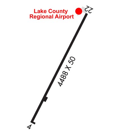
| Lat: N 3635.8 Long: W 07833.6 Elev: 421 Var: +08 Longest Runway: 4007 | ||
| AWOS: 118.22 CTAF: 122.9 | ||
| |||||||||||||||||||||||||||||||||||||||||||||||||||||||||||||
| |||||||||||||||||||||||||||||||||||||||||||||||||||||||||||||
| |||||||||||||||||||||||||||||||||||||||||||||||||||||||||||||
| Rwy | Rwy | |||||||
| 4007x50 | 4007' | 4007x50 | 3527' | |||||
| Runway ID | Single Wheel | Double Wheel | Double Tandem Wheel | Dual Double Wheel |
| 04/22 | 12,500 | N/A | N/A | N/A |
| These numbers are Advisory and are not limits. The Airport Manager should have more accurate Weight Limits | ||||
 Airport Diagram might not be current. | |
| Facility Name: | LAKE COUNTRY RGNL |
| City Name: | CLARKSVILLE |
| County: | MECKLENBURG |
| State abbrev: | VA |
| State Name: | VIRGINIA |
| Ownership: | PUBLICLY OWNED |
| Use: | OPEN TO THE PUBLIC |
| Owner's Name: | LAKE COUNTRY REG AIRPORT COMMISSION |
| Address: | LAKE COUNTRY REGIONAL AIRPORT, POST OFFICE BOX 1047 |
| CLARKSVILLE, VA 23927 | |
| Owner's Phone: | 434-374-8028 |
| Manager's Name: | MICHAEL DENTON |
| Address: | LAKE COUNTRY REGIONAL AIRPORT, 11632 HWY 15 |
| CLARKSVILLE, VA 23927 | |
| Phone: | 434-374-8028 |
| FAA Region: | EASTERN |
| FAA Field Office: | DCA |
| Date | Sunrise | Sunset |
|---|---|---|
| 06/08/26 Monday | 5:56 | 20:31 |
| 06/09/26 Tuesday | 5:55 | 20:32 |
| 06/10/26 Wednesday | 5:55 | 20:32 |
| 06/11/26 Thursday | 5:55 | 20:33 |
| 06/12/26 Friday | 5:55 | 20:33 |
| 06/13/26 Saturday | 5:55 | 20:33 |
| 06/14/26 Sunday | 5:55 | 20:34 |
| 06/15/26 Monday | 5:55 | 20:34 |
| 06/16/26 Tuesday | 5:55 | 20:35 |
| 06/17/26 Wednesday | 5:55 | 20:35 |
| 06/18/26 Thursday | 5:55 | 20:35 |
| 06/19/26 Friday | 5:56 | 20:35 |
| 06/20/26 Saturday | 5:56 | 20:36 |
| 06/21/26 Sunday | 5:56 | 20:36 |
| Airport Attendance Schedule | 7 Days A Week 0800-1700 |
| Airport Status | OPERATIONAL (This Status can change at any time - please check NOTAMS) |
| Airport Lighting Schedule | SS-SR |
| Airport Storage Available | Tie Downs |
| Extra Services Available | NONE |
| Wind Indicator | YES - (unlit) |
| Control Tower | NO |
| CTAF Frequency | 122.900 |
| Unicom Frequency | |
| Rotating Beacon Color | WG |
| Segmented Circle | NO |
| Landing Fee | NO |
| Airport Inspected | STATE - performed by STATE AERONAUTICAL PERSONNEL |
| Inspection Date | 06/10/2025 |
| Type of Fuel Available | Grade 100LL |
| Airframe Repair Service | NONE |
| Power Plant Repair Service | NONE |
| Latitude | N3635.8 |
| Longitude | W07833.6 (ESTIMATED) |
| Arpt Elevation | 420ft (ESTIMATED) |
| Magnetic Variation | 08W |
| 2 miles S | of CLARKSVILLE |
| Traffic Pattern Altitude | 800 |
| Sectional Chart | WASHINGTON |
| Operations (Reported) | Yearly | Avg. Daily |
|---|---|---|
| General Aviation Transient | 0 | 0 |
| General Aviation Local | 0 | 0 |
| Air Taxi | 0 | 0 |
| Commerical | 0 | 0 |
| Commuter | 0 | 0 |
| Military | 0 | 0 |
| Aircraft based on Field | |
|---|---|
| General Aviation Singles | 0 |
| General Aviation Multi | 0 |
| Jet Aircraft | 0 |
| General Aviation Helicopters | 0 |
| Military Aircraft | 0 |
| Gliders | 0 |
| Ultralights | 0 |
| FSS on field | NO |
| FSS tie-in | LEESBURG |
| FSS Phone | 1-800-WX-BRIEF |
| Who issues Notams | DCA |
| Notam D service at airport | YES |
| ARTCC Name | WASHINGTON |
| Airport Certification | |
| Aircraft Rescue & Firefighting Index | None |
| Airport of Entry | No |
| Custom Landing Rights | No |
| Joint Civil/Military | No |
| Military Landing rights | No |
| WILDLIFE INVOF ARPT. |
| SELF SVC FUEL AVBL. |
| FOR CD CTC WASHINGTON ARTCC AT 703-771-3587. |
Airport Communications & Frequencies:
| |||||||
| Runway: 04 | Runway: 22 | ||
| Mag heading: | 36° | Mag heading: | 216° |
| Rwy Slope: | .95% Up | Rwy Slope: | -.95% Down |
| Approach: | Approach: | ||
| Pattern: | Left Traffic | Pattern: | Left Traffic |
| Markings: | NONPRECISION INSTRUMENT | Markings: | BASIC |
| Marking Condition: | GOOD | Marking Condition: | GOOD |
| Arresting Dev: | Arresting Dev: | ||
| Lat & Long: | N3635.5 W07833.8 | Lat. & Long.: | N3636.1 W07833.4 |
| Elev: | 373.7 ft. MSL | Elev: | 411.8 ft. MSL |
| TCH: | TCH: | ||
| Visual Glide Path: | Visual Glide Path: | ||
| Displaced Threshold: | No | Displaced Threshold: | 480 feet |
| Touchdown Zone: | YES | Touchdown Zone: | YES |
| Touchdown Elev.: | 397.9 feet | Touchdown Elev.: | 420.9 feet |
| Visual Glide Slope: | Visual Glide Slope: | ||
| RVR Equipment: | RVR Equipment: | ||
| RVV Equipment: | NO | RVV Equipment: | NO |
| Approach Lights: | Approach Lights: | ||
| REIL: | NO | REIL: | NO |
| Centerline Lights: | NO | Centerline Lights: | NO |
| Touchdown lights: | NO | Touchdown lights: | NO |
| Runway Category: | Runway with a Visual Approach | Runway Category: | Runway with a Visual Approach |
| Declared Distances: | Declared Distances: | ||
| Obstructions: | TREE | Obstructions: | ROAD |
| Marked: | NOT Marked/Lighted | Marked: | NOT Marked/Lighted |
| Clearance slope: | 7:1 | Clearance slope: | 1:1; RYW 22 APCH SLOPE 15:1 TO DSPLCD THR FROM 82 FT TREE 1502 FT FR DSPLCD THR, 142 FT L. |
| Obstruction height: | 29 feet AGL | Obstruction height: | 18 feet AGL |
| Dist. from runway: | 416 feet | Dist. from runway: | 200 feet |
| Centerline offset: | 279 right of centerline | Centerline offset: | |
| Comments: | CLOSE-IN OBSTN, 27 FT ABV RWY SFC, ROW OF TREES 179 FT RIGHT OF CNTRLN ON APCH. | Comments: | ROAD CROSSING 170 FT FROM END OF RWY. BUILDING 27 FT, 90 FT FROM END OF RWY, 110 FT L. |
Thanks for using FltPlan.com
all rights reserved © 1999-2026 by Flight Plan LLC