
| LUNENBURG COUNTY KENBRIDGE VA |
| |
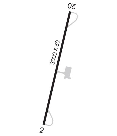
| Lat: N 3657.6 Long: W 07811.1 Elev: 526 Var: +10 Longest Runway: 3000 | ||
| AWOS: 123.87 CTAF: 122.7 | ||
| ||||||||||||||||||||||||||||||||
| ||||||||||||||||||||||||||||||||
| ||||||||||||||||||||||||||||||||
| Rwy | Rwy | |||||||
| 3000x50 | 3000' | 3000x50 | 3000' | |||||
| Runway ID | Single Wheel | Double Wheel | Double Tandem Wheel | Dual Double Wheel |
| 02/20 | 12,500 | N/A | N/A | N/A |
| These numbers are Advisory and are not limits. The Airport Manager should have more accurate Weight Limits | ||||
 Airport Diagram might not be current. | |
| Facility Name: | LUNENBURG COUNTY |
| City Name: | KENBRIDGE |
| County: | LUNENBURG |
| State abbrev: | VA |
| State Name: | VIRGINIA |
| Ownership: | PUBLICLY OWNED |
| Use: | OPEN TO THE PUBLIC |
| Owner's Name: | LUNENBURG COUNTY |
| Address: | 11409 COURTHOUSE RD, ATTN: COUNTY ADMINISTRATOR |
| LUNENBURG, VA 23952 | |
| Owner's Phone: | 434-696-2142 |
| Manager's Name: | LARRY WAY |
| Address: | 634 AIRPORT ROAD |
| VICTORIA, VA 23974 | |
| Phone: | 301-524-0053 |
| FAA Region: | EASTERN |
| FAA Field Office: | DCA |
| Date | Sunrise | Sunset |
|---|---|---|
| 09/24/21 Friday | 7:02 | 19:07 |
| 09/25/21 Saturday | 7:03 | 19:05 |
| 09/26/21 Sunday | 7:04 | 19:04 |
| 09/27/21 Monday | 7:04 | 19:02 |
| 09/28/21 Tuesday | 7:05 | 19:01 |
| 09/29/21 Wednesday | 7:06 | 18:59 |
| 09/30/21 Thursday | 7:07 | 18:58 |
| 10/01/21 Friday | 7:08 | 18:56 |
| 10/02/21 Saturday | 7:09 | 18:55 |
| 10/03/21 Sunday | 7:10 | 18:53 |
| 10/04/21 Monday | 7:10 | 18:52 |
| 10/05/21 Tuesday | 7:11 | 18:51 |
| 10/06/21 Wednesday | 7:12 | 18:49 |
| 10/07/21 Thursday | 7:13 | 18:48 |
| Airport Attendance Schedule | UNATTENDED |
| Airport Status | OPERATIONAL (This Status can change at any time - please check NOTAMS) |
| Airport Lighting Schedule | SS-SR |
| Airport Storage Available | Tie Downs |
| Extra Services Available | NONE |
| Wind Indicator | YES - (lighted) |
| Control Tower | NO |
| CTAF Frequency | 122.700 |
| Unicom Frequency | 122.700 |
| Rotating Beacon Color | CLEAR-GREEN (Light Land Airport) |
| Segmented Circle | NO |
| Landing Fee | NO |
| Airport Inspected | STATE - performed by STATE AERONAUTICAL PERSONNEL |
| Inspection Date | 08/24/2020 |
| Type of Fuel Available | Grade 100LL; -10FUEL AVAILABLE DAYLIGHT HOURS BY CALLING AIRPORT MANAGER 301-524-0053. |
| Airframe Repair Service | NONE |
| Power Plant Repair Service | NONE |
| Latitude | N3657.6 |
| Longitude | W07811.1 (ESTIMATED) |
| Arpt Elevation | 526ft (SURVEYED) |
| Magnetic Variation | 10W |
| 3 miles W | of KENBRIDGE |
| Traffic Pattern Altitude | |
| Sectional Chart | WASHINGTON |
| Operations (Reported) | Yearly | Avg. Daily |
|---|---|---|
| General Aviation Transient | 86 | 0 |
| General Aviation Local | 320 | 1 |
| Air Taxi | 0 | 0 |
| Commerical | 0 | 0 |
| Commuter | 0 | 0 |
| Military | 0 | 0 |
| Aircraft based on Field | |
|---|---|
| General Aviation Singles | 1 |
| General Aviation Multi | 0 |
| Jet Aircraft | 0 |
| General Aviation Helicopters | 0 |
| Military Aircraft | 0 |
| Gliders | 0 |
| Ultralights | 0 |
| FSS on field | NO |
| FSS tie-in | LEESBURG |
| FSS Phone | 1-800-WX-BRIEF |
| Who issues Notams | DCA |
| Notam D service at airport | YES |
| ARTCC Name | WASHINGTON |
| Airport Certification | |
| Aircraft Rescue & Firefighting Index | None |
| Airport of Entry | No |
| Custom Landing Rights | No |
| Joint Civil/Military | No |
| Military Landing rights | YES |
| ASSURANCES PURSUANT TO TITLE VI, CIVIL RIGHTS ACT OF 1964 |
| GRANT AGREEMENT HAS EXPIRED; HOWEVER, AGREEMENT REMAINS IN EFFECT FOR THIS FACILITY AS LONG AS IT IS PUBLIC USE. |
| DEER ON AND INVOF ARPT. |
| PARACHUTE ACTIVITY IN & INVOF AIRPORT. |
| FOR CD CTC WASHINGTON ARTCC AT 703-771-3587. |
| RWY 02/2 0 NMRS CRACKS IN RWY. CONVENTIONAL GEAR ACFT BE ALERT. |
Airport Communications & Frequencies:
| |||||||||
| Runway: 02 | Runway: 20 | ||
| Mag heading: | 23° | Mag heading: | 203° |
| Rwy Slope: | .43% Up | Rwy Slope: | -.43% Down |
| Approach: | Approach: | ||
| Pattern: | Left Traffic | Pattern: | Left Traffic |
| Markings: | BASIC | Markings: | BASIC |
| Marking Condition: | FAIR | Marking Condition: | FAIR |
| Arresting Dev: | Arresting Dev: | ||
| Lat & Long: | N3657.4 W07811.2 | Lat. & Long.: | N3657.9 W07811.0 |
| Elev: | 512.0 ft. MSL | Elev: | 525.0 ft. MSL |
| TCH: | 26 ft. AGL | TCH: | 26 ft. AGL |
| Visual Glide Path: | 5.00 degrees | Visual Glide Path: | 5.00 degrees |
| Displaced Threshold: | No | Displaced Threshold: | No |
| Touchdown Zone: | YES | Touchdown Zone: | YES |
| Touchdown Elev.: | 526.0 feet | Touchdown Elev.: | 526.0 feet |
| Visual Glide Slope: | SYSTEM OF PANELS ON LEFT SIDE OF RUNWAY (May NOT Be Lighted) | Visual Glide Slope: | SYSTEM OF PANELS ON LEFT SIDE OF RUNWAY (May NOT Be Lighted) |
| RVR Equipment: | RVR Equipment: | ||
| RVV Equipment: | NO | RVV Equipment: | NO |
| Approach Lights: | Approach Lights: | ||
| REIL: | NO | REIL: | NO |
| Centerline Lights: | NO | Centerline Lights: | NO |
| Touchdown lights: | NO | Touchdown lights: | NO |
| Runway Category: | Runway with a Visual Approach | Runway Category: | Runway with a Visual Approach |
| Declared Distances: | Declared Distances: | ||
| Obstructions: | TREE | Obstructions: | BRUSH |
| Marked: | NOT Marked/Lighted | Marked: | NOT Marked/Lighted |
| Clearance slope: | 10:1 | Clearance slope: | 4:1 |
| Obstruction height: | 31 feet AGL | Obstruction height: | 15 feet AGL |
| Dist. from runway: | 515 feet | Dist. from runway: | 263 feet |
| Centerline offset: | 35 left of centerline | Centerline offset: | 27 feet right of centerline |
| Comments: | Comments: |
Thanks for using FltPlan.com
all rights reserved © 1999-2021 by Flight Plan LLC
