
| BAY BRIDGE STEVENSVILLE MD |
| |
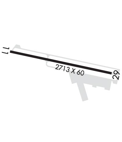
| Lat: N 3858.6 Long: W 07619.8 Elev: 15 Var: +11 Longest Runway: 2713 | ||
| AWOS: 120.57 CTAF: 122.72 | ||
| ||||||
| ||||||
|
| Rwy | Rwy | |||||||
| 2713x60 | 2713' | 2713x60 | 2713' | |||||
| Runway ID | Single Wheel | Double Wheel | Double Tandem Wheel | Dual Double Wheel |
| 11/29 | N/A | N/A | N/A | N/A |
| These numbers are Advisory and are not limits. The Airport Manager should have more accurate Weight Limits | ||||
 Airport Diagram might not be current. | |
| Facility Name: | BAY BRIDGE |
| City Name: | STEVENSVILLE |
| County: | QUEEN ANNES |
| State abbrev: | MD |
| State Name: | MARYLAND |
| Ownership: | PUBLICLY OWNED |
| Use: | OPEN TO THE PUBLIC |
| Owner's Name: | QUEEN ANNE COUNTY |
| Address: | 107 N LIBERTY ST |
| STEVENSVILLE, MD 21617 | |
| Owner's Phone: | 410-798-4098 |
| Manager's Name: | LINDA K. STEINER |
| Address: | 202 AIRPORT RD |
| STEVENSVILLE, MD 21666 | |
| Phone: | 410-643-4364 |
| FAA Region: | EASTERN |
| FAA Field Office: | DCA |

| Date | Sunrise | Sunset |
|---|---|---|
| 09/24/21 Friday | 6:55 | 19:00 |
| 09/25/21 Saturday | 6:55 | 18:58 |
| 09/26/21 Sunday | 6:56 | 18:56 |
| 09/27/21 Monday | 6:57 | 18:55 |
| 09/28/21 Tuesday | 6:58 | 18:53 |
| 09/29/21 Wednesday | 6:59 | 18:52 |
| 09/30/21 Thursday | 7:00 | 18:50 |
| 10/01/21 Friday | 7:01 | 18:48 |
| 10/02/21 Saturday | 7:02 | 18:47 |
| 10/03/21 Sunday | 7:03 | 18:45 |
| 10/04/21 Monday | 7:04 | 18:44 |
| 10/05/21 Tuesday | 7:05 | 18:42 |
| 10/06/21 Wednesday | 7:06 | 18:41 |
| 10/07/21 Thursday | 7:07 | 18:39 |
| Airport Attendance Schedule | MON-SAT 0730-1630, SUN UNATTENDED |
| Airport Status | OPERATIONAL (This Status can change at any time - please check NOTAMS) |
| Airport Lighting Schedule | DUSK-DAWN; ACTVT REIL RWY 11 & 29; MIRL RWY 11/29 - CTAF. |
| Airport Storage Available | Tie Downs |
| Extra Services Available | Flight Instruction, Aircraft Rental, Aircraft Sales |
| Wind Indicator | YES - (lighted) |
| Control Tower | NO |
| CTAF Frequency | 122.725 |
| Unicom Frequency | 122.725 |
| Rotating Beacon Color | CLEAR-GREEN (Light Land Airport) |
| Segmented Circle | NO |
| Landing Fee | NO; PRKG FEE. |
| Airport Inspected | STATE - performed by STATE AERONAUTICAL PERSONNEL |
| Inspection Date | 07/06/2021 |
| Type of Fuel Available | Grade 100LL; -10SELF SERVE AVBL H24 WITH CREDIT CARD. |
| Airframe Repair Service | MAJOR |
| Power Plant Repair Service | MAJOR |
| Latitude | N3858.6 |
| Longitude | W07619.8 (ESTIMATED) |
| Arpt Elevation | 14ft (SURVEYED) |
| Magnetic Variation | 11W |
| 1 miles W | of STEVENSVILLE |
| Traffic Pattern Altitude | 1200 |
| Sectional Chart | WASHINGTON |
| Operations (Reported) | Yearly | Avg. Daily |
|---|---|---|
| General Aviation Transient | 12768 | 35 |
| General Aviation Local | 22400 | 61 |
| Air Taxi | 112 | 0 |
| Commerical | 0 | 0 |
| Commuter | 0 | 0 |
| Military | 0 | 0 |
| Aircraft based on Field | |
|---|---|
| General Aviation Singles | 70 |
| General Aviation Multi | 6 |
| Jet Aircraft | 0 |
| General Aviation Helicopters | 2 |
| Military Aircraft | 0 |
| Gliders | 0 |
| Ultralights | 0 |
| FSS on field | NO |
| FSS tie-in | LEESBURG |
| FSS Phone | 1-800-WX-BRIEF |
| Who issues Notams | W29 |
| Notam D service at airport | YES |
| ARTCC Name | WASHINGTON |
| Airport Certification | |
| Aircraft Rescue & Firefighting Index | None |
| Airport of Entry | No |
| Custom Landing Rights | No |
| Joint Civil/Military | No |
| Military Landing rights | No |
| NATIONAL PLAN OF INTEGRATED AIRPORT SYSTEMS (NPIAS) |
| GRANT AGREEMENTS UNDER FAAP/ADAP/AIP |
| ASSURANCES PURSUANT TO TITLE VI, CIVIL RIGHTS ACT OF 1964 |
| TGL OPS NA. |
| WILDLIFE ON & INVOF ARPT. |
| NOISE ABATEMENT PROC IN EFCT - AMGR. NOISE SENSITIVE RESIDENTIAL AREA S OF ARPT; ENTER DOWNWIND FOR RWY 29 OVER WATER TWR S OF FLD. |
| ALERT HELI 8 NM EAST OF ARPT. |
| FOR CD CTC POTOMAC APCH AT 866-429-5882. |
| ROTOR CRAFT: USE R PAT FOR RWY 29. AT ALL OTR TIMES, USE L TFC PAT. |
Airport Communications & Frequencies:
| ||||||||||||||
| Runway: 11 | Runway: 29 | ||
| Mag heading: | 114° | Mag heading: | 294° |
| Rwy Slope: | .35% Up | Rwy Slope: | -.35% Down |
| Approach: | Approach: | ||
| Pattern: | Left Traffic | Pattern: | Left Traffic |
| Markings: | NONPRECISION INSTRUMENT | Markings: | NONPRECISION INSTRUMENT |
| Marking Condition: | GOOD | Marking Condition: | GOOD |
| Arresting Dev: | Arresting Dev: | ||
| Lat & Long: | N3858.6 W07620.1 | Lat. & Long.: | N3858.5 W07619.5 |
| Elev: | 5.2 ft. MSL | Elev: | 14.6 ft. MSL |
| TCH: | 39 ft. AGL | TCH: | 30 ft. AGL |
| Visual Glide Path: | 3.00 degrees | Visual Glide Path: | 3.00 degrees |
| Displaced Threshold: | No | Displaced Threshold: | No |
| Touchdown Zone: | YES | Touchdown Zone: | YES |
| Touchdown Elev.: | 14.8 feet | Touchdown Elev.: | 14.8 feet |
| Visual Glide Slope: | 2-Light PAPI on LEFT side of Runway; UNUSBL BYD 5 DEG LEFT OF CNTRLN; PAPIS BAFFLED. | Visual Glide Slope: | 2-Light PAPI on LEFT side of Runway |
| RVR Equipment: | RVR Equipment: | ||
| RVV Equipment: | NO | RVV Equipment: | NO |
| Approach Lights: | Approach Lights: | ||
| REIL: | YES | REIL: | YES |
| Centerline Lights: | NO | Centerline Lights: | NO |
| Touchdown lights: | NO | Touchdown lights: | NO |
| Runway Category: | Runway with a Non-precision Approach | Runway Category: | Runway with a Non-precision Approach |
| Declared Distances: | Declared Distances: | ||
| Obstructions: | Obstructions: | TREES | |
| Marked: | Marked: | NOT Marked/Lighted | |
| Clearance slope: | 20:1 | Clearance slope: | 21:1 |
| Obstruction height: | Obstruction height: | 23 feet AGL | |
| Dist. from runway: | Dist. from runway: | 699 feet | |
| Centerline offset: | Centerline offset: | 154 feet left of centerline | |
| Comments: | Comments: |
Thanks for using FltPlan.com
all rights reserved © 1999-2021 by Flight Plan LLC