| EAGLE'S NEST WAYNESBORO VA |
| |
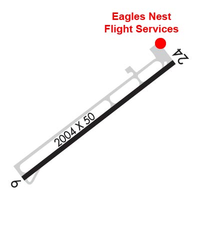
| Lat: N 3804.6 Long: W 07856.7 Elev: 1436 Var: +09 Longest Runway: 2004 | ||
| AWOS: 118.62 CTAF: 123.05 | ||
| |||||||||||||||||||||||||||||||||||||||||||||||||||||||||||||
| |||||||||||||||||||||||||||||||||||||||||||||||||||||||||||||
| |||||||||||||||||||||||||||||||||||||||||||||||||||||||||||||
| Rwy | Rwy | |||||||
| 2004x50 | 2004' | 2004x50 | 2004' | |||||
| Runway ID | Single Wheel | Double Wheel | Double Tandem Wheel | Dual Double Wheel |
| 06/24 | N/A | N/A | N/A | N/A |
| These numbers are Advisory and are not limits. The Airport Manager should have more accurate Weight Limits | ||||
 Airport Diagram might not be current. | |
| Facility Name: | EAGLE'S NEST |
| City Name: | WAYNESBORO |
| County: | AUGUSTA |
| State abbrev: | VA |
| State Name: | VIRGINIA |
| Ownership: | PRIVATELY OWNED |
| Use: | OPEN TO THE PUBLIC |
| Owner's Name: | MICHAEL L FOGLE |
| Address: | P. O. BOX 691236 |
| CHARLOTTE, NC 28227-7021 | |
| Owner's Phone: | 704-576-3500 |
| Manager's Name: | MICHAEL T.K. ROSOLINA |
| Address: | 249 AERO DR |
| WAYNESBORO, VA 22980 | |
| Phone: | 540-943-4447 |
| FAA Region: | EASTERN |
| FAA Field Office: | DCA |
| Date | Sunrise | Sunset |
|---|---|---|
| 06/08/26 Monday | 5:53 | 20:37 |
| 06/09/26 Tuesday | 5:53 | 20:37 |
| 06/10/26 Wednesday | 5:53 | 20:38 |
| 06/11/26 Thursday | 5:52 | 20:38 |
| 06/12/26 Friday | 5:52 | 20:39 |
| 06/13/26 Saturday | 5:52 | 20:39 |
| 06/14/26 Sunday | 5:52 | 20:40 |
| 06/15/26 Monday | 5:52 | 20:40 |
| 06/16/26 Tuesday | 5:52 | 20:41 |
| 06/17/26 Wednesday | 5:52 | 20:41 |
| 06/18/26 Thursday | 5:53 | 20:41 |
| 06/19/26 Friday | 5:53 | 20:41 |
| 06/20/26 Saturday | 5:53 | 20:42 |
| 06/21/26 Sunday | 5:53 | 20:42 |
| Airport Attendance Schedule | MON - FRI 0800 - 1700, SUN 1000 - 1600, SAT 0900 - 1600 |
| Airport Status | OPERATIONAL (This Status can change at any time - please check NOTAMS) |
| Airport Lighting Schedule | ACTVT MIRL RWY 06/24 - CTAF. |
| Airport Storage Available | Tie Downs, Hanger |
| Extra Services Available | Glider, Flight Instruction, Aircraft Rental |
| Wind Indicator | YES - (unlit) |
| Control Tower | NO |
| CTAF Frequency | 123.050 |
| Unicom Frequency | 123.050 |
| Rotating Beacon Color | WG |
| Segmented Circle | NO |
| Landing Fee | NO |
| Airport Inspected | STATE - performed by STATE AERONAUTICAL PERSONNEL |
| Inspection Date | 08/29/2025 |
| Type of Fuel Available | Grade 100LL |
| Airframe Repair Service | MAJOR |
| Power Plant Repair Service | MAJOR |
| Latitude | N3804.6 |
| Longitude | W07856.7 (ESTIMATED) |
| Arpt Elevation | 1436ft (ESTIMATED) |
| Magnetic Variation | 09W |
| 3 miles W | of WAYNESBORO |
| Traffic Pattern Altitude | |
| Sectional Chart | WASHINGTON |
| Operations (Reported) | Yearly | Avg. Daily |
|---|---|---|
| General Aviation Transient | 0 | 0 |
| General Aviation Local | 0 | 0 |
| Air Taxi | 0 | 0 |
| Commerical | 0 | 0 |
| Commuter | 0 | 0 |
| Military | 0 | 0 |
| Aircraft based on Field | |
|---|---|
| General Aviation Singles | 0 |
| General Aviation Multi | 0 |
| Jet Aircraft | 0 |
| General Aviation Helicopters | 0 |
| Military Aircraft | 0 |
| Gliders | 0 |
| Ultralights | 0 |
| FSS on field | NO |
| FSS tie-in | LEESBURG |
| FSS Phone | 1-800-WX-BRIEF |
| Who issues Notams | DCA |
| Notam D service at airport | YES |
| ARTCC Name | WASHINGTON |
| Airport Certification | |
| Aircraft Rescue & Firefighting Index | None |
| Airport of Entry | No |
| Custom Landing Rights | No |
| Joint Civil/Military | No |
| Military Landing rights | No |
| DEER ON AND INVOF ARPT. |
| NO REPETITIVE PRACTICE TKOFS AND LDGS AFT 0100Z. |
| NO GRASS LANDINGS OR TAKEOFFS EITHER SIDE OF RWY 06/24. |
| FOR CD CTC POTOMAC APCH AT 866-640-4124. |
Airport Communications & Frequencies:
| ||||||||||||||
| Runway: 06 | Runway: 24 | ||
| Mag heading: | N/A | Mag heading: | N/A |
| Rwy Slope: | -.30% Down | Rwy Slope: | .30% Up |
| Approach: | Approach: | ||
| Pattern: | Left Traffic | Pattern: | Left Traffic |
| Markings: | NUMBERS ONLY | Markings: | NUMBERS ONLY |
| Marking Condition: | GOOD | Marking Condition: | GOOD |
| Arresting Dev: | Arresting Dev: | ||
| Lat & Long: | N3804.5 W07856.8 | Lat. & Long.: | N3804.7 W07856.5 |
| Elev: | 1436.0 ft. MSL | Elev: | 1430.0 ft. MSL |
| TCH: | TCH: | ||
| Visual Glide Path: | Visual Glide Path: | ||
| Displaced Threshold: | No | Displaced Threshold: | No |
| Touchdown Zone: | YES | Touchdown Zone: | YES |
| Touchdown Elev.: | 1436.0 feet | Touchdown Elev.: | 1436.0 feet |
| Visual Glide Slope: | Visual Glide Slope: | ||
| RVR Equipment: | RVR Equipment: | ||
| RVV Equipment: | NO | RVV Equipment: | NO |
| Approach Lights: | Approach Lights: | ||
| REIL: | NO | REIL: | NO |
| Centerline Lights: | NO | Centerline Lights: | NO |
| Touchdown lights: | NO | Touchdown lights: | NO |
| Runway Category: | Runway with a Non-precision Approach | Runway Category: | Runway with a Non-precision Approach |
| Declared Distances: | Declared Distances: | ||
| Obstructions: | TREE | Obstructions: | TREE |
| Marked: | NOT Marked/Lighted | Marked: | NOT Marked/Lighted |
| Clearance slope: | 6:1 | Clearance slope: | 11:1 |
| Obstruction height: | 48 feet AGL | Obstruction height: | 28 feet AGL |
| Dist. from runway: | 490 feet | Dist. from runway: | 535 feet |
| Centerline offset: | 117 left of centerline | Centerline offset: | 136 feet left of centerline |
| Comments: | 8 FT BRUSH AND TREES LEFT SIDE OF RWY APRXLY 155 FM THR AND 108 FT FM CNTRLN. | Comments: |
Thanks for using FltPlan.com
all rights reserved © 1999-2026 by Flight Plan LLC