
| WILSON INDUSTRIAL AIR CENTER WILSON NC |
| |
| Lat: N 3546.2 Long: W 07758.2 Elev: 160 Var: +08 Longest Runway: 4500 | ||
| CTAF: 123.0 | ||
| ||||||||||||||||||||||||||||||||||||||||||||
| ||||||||||||||||||||||||||||||||||||||||||||
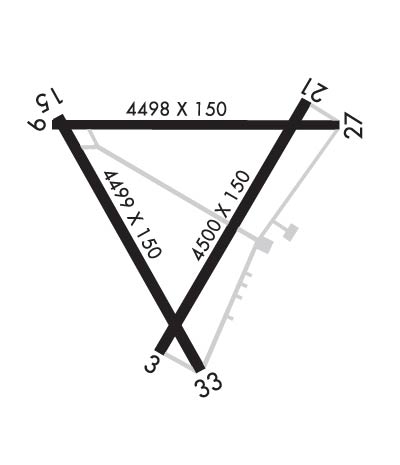
| Rwy | Rwy | |||||||
| 4500x150 | 4500' | 4500x150 | 4500' | |||||
| 4498x150 | 4498' | 4498x150 | 4498' | |||||
| 4499x150 | 4499' | 4499x150 | 4499' | |||||
| Runway ID | Single Wheel | Double Wheel | Double Tandem Wheel | Dual Double Wheel |
| 03/21 | 20,000 | N/A | N/A | N/A |
| 09/27 | 20,000 | N/A | N/A | N/A |
| 15/33 | 20,000 | N/A | N/A | N/A |
| These numbers are Advisory and are not limits. The Airport Manager should have more accurate Weight Limits | ||||
 Airport Diagram might not be current. | |
| Facility Name: | WILSON INDUSTRIAL AIR CENTER |
| City Name: | WILSON |
| County: | WILSON |
| State abbrev: | NC |
| State Name: | NORTH CAROLINA |
| Ownership: | PUBLICLY OWNED |
| Use: | OPEN TO THE PUBLIC |
| Owner's Name: | CITY OF WILSON |
| Address: | PO BOX 10 |
| WILSON, NC 27894 | |
| Owner's Phone: | 252-399-2489 |
| Manager's Name: | GRONNA JONES |
| Address: | PO BOX 10 |
| WILSON, NC 27894 | |
| Phone: | 252-399-2489; ARPT PHONE NR 252-991-6336. |
| FAA Region: | SOUTHERN |
| FAA Field Office: | MEM |
| Date | Sunrise | Sunset |
|---|---|---|
| 06/08/26 Monday | 5:55 | 20:26 |
| 06/09/26 Tuesday | 5:55 | 20:27 |
| 06/10/26 Wednesday | 5:55 | 20:27 |
| 06/11/26 Thursday | 5:55 | 20:28 |
| 06/12/26 Friday | 5:55 | 20:28 |
| 06/13/26 Saturday | 5:55 | 20:29 |
| 06/14/26 Sunday | 5:55 | 20:29 |
| 06/15/26 Monday | 5:55 | 20:29 |
| 06/16/26 Tuesday | 5:55 | 20:30 |
| 06/17/26 Wednesday | 5:55 | 20:30 |
| 06/18/26 Thursday | 5:55 | 20:30 |
| 06/19/26 Friday | 5:56 | 20:31 |
| 06/20/26 Saturday | 5:56 | 20:31 |
| 06/21/26 Sunday | 5:56 | 20:31 |
| Airport Attendance Schedule | 7 Days A Week 0800-1800; UNATNDD THANKSGIVING AND CHRISTMAS DAY. FOR SVC AFT HRS CALL 252-361-0663. |
| Airport Status | OPERATIONAL (This Status can change at any time - please check NOTAMS) |
| Airport Lighting Schedule | ACTVT REIL RWY 03/21; MIRL RWY 03/21 - CTAF. |
| Airport Storage Available | Tie Downs, Hanger |
| Extra Services Available | NONE |
| Wind Indicator | YES - (lighted) |
| Control Tower | NO |
| CTAF Frequency | 123.000 |
| Unicom Frequency | 123.000 |
| Rotating Beacon Color | WG |
| Segmented Circle | NO |
| Landing Fee | NO |
| Airport Inspected | STATE - performed by STATE AERONAUTICAL PERSONNEL |
| Inspection Date | 05/25/2024 |
| Type of Fuel Available | Grade 100LL, JET A-1 (icing inhibitor, freeze point -50C) |
| Airframe Repair Service | NONE |
| Power Plant Repair Service | NONE |
| Latitude | N3546.2 |
| Longitude | W07758.2 (ESTIMATED) |
| Arpt Elevation | 159ft (SURVEYED) |
| Magnetic Variation | 08W |
| 3 miles N | of WILSON |
| Traffic Pattern Altitude | |
| Sectional Chart | CHARLOTTE |
| Operations (Reported) | Yearly | Avg. Daily |
|---|---|---|
| General Aviation Transient | 0 | 0 |
| General Aviation Local | 0 | 0 |
| Air Taxi | 0 | 0 |
| Commerical | 0 | 0 |
| Commuter | 0 | 0 |
| Military | 0 | 0 |
| Aircraft based on Field | |
|---|---|
| General Aviation Singles | 0 |
| General Aviation Multi | 0 |
| Jet Aircraft | 0 |
| General Aviation Helicopters | 0 |
| Military Aircraft | 0 |
| Gliders | 0 |
| Ultralights | 0 |
| FSS on field | NO |
| FSS tie-in | RALEIGH |
| FSS Phone | 1-800-WX-BRIEF |
| Who issues Notams | RDU |
| Notam D service at airport | YES |
| ARTCC Name | WASHINGTON |
| Airport Certification | |
| Aircraft Rescue & Firefighting Index | None |
| Airport of Entry | No |
| Custom Landing Rights | No |
| Joint Civil/Military | No |
| Military Landing rights | YES |
| SURPLUS PROPERTY AGREEMENT UNDER PUBLIC LAW 289 |
| SURPLUS PROPERTY AGREEMENT UNDER REGULATION 16-WAA |
| GRANT AGREEMENT HAS EXPIRED; HOWEVER, AGREEMENT REMAINS IN EFFECT FOR THIS FACILITY AS LONG AS IT IS PUBLIC USE. |
| AGREEMENT UNDER DLAND OR DCLA HAS EXPIRED. |
| NO LINE-OF-SIGHT BTN RWY ENDS. |
| DEER ON & INVOF ARPT. |
| FOR CD CTC WASHINGTON ARTCC AT 703-771-3587. |
| RWY 09/2 7 ROUGH SFC DUE TO EXCESSIVE CRACK SEALANT. |
| RWY 15/3 3 L & T AND BLOCK CRACKING, FOD, FAILED SEALANT. |
Airport Communications & Frequencies:
| |||||||||
| Runway: 03 | Runway: 21 | ||
| Mag heading: | 39° | Mag heading: | 219° |
| Rwy Slope: | -.02% Down | Rwy Slope: | .02% Up |
| Approach: | Approach: | ||
| Pattern: | Left Traffic | Pattern: | Left Traffic |
| Markings: | NONPRECISION INSTRUMENT | Markings: | NONPRECISION INSTRUMENT |
| Marking Condition: | FAIR | Marking Condition: | FAIR |
| Arresting Dev: | Arresting Dev: | ||
| Lat & Long: | N3545.8 W07758.3 | Lat. & Long.: | N3546.5 W07757.8 |
| Elev: | 155.5 ft. MSL | Elev: | 154.8 ft. MSL |
| TCH: | TCH: | ||
| Visual Glide Path: | Visual Glide Path: | ||
| Displaced Threshold: | No | Displaced Threshold: | No |
| Touchdown Zone: | YES | Touchdown Zone: | YES |
| Touchdown Elev.: | 155.5 feet | Touchdown Elev.: | 157.4 feet |
| Visual Glide Slope: | Visual Glide Slope: | ||
| RVR Equipment: | RVR Equipment: | ||
| RVV Equipment: | NO | RVV Equipment: | NO |
| Approach Lights: | Approach Lights: | ||
| REIL: | YES; RWY 03/21 OTS INDEF. | REIL: | YES |
| Centerline Lights: | NO | Centerline Lights: | NO |
| Touchdown lights: | NO | Touchdown lights: | NO |
| Runway Category: | Runway with a Non-precision Approach | Runway Category: | Runway with a Non-precision Approach |
| Declared Distances: | Declared Distances: | ||
| Obstructions: | TREES | Obstructions: | TREES |
| Marked: | NOT Marked/Lighted | Marked: | NOT Marked/Lighted |
| Clearance slope: | 21:1 | Clearance slope: | 5:1 |
| Obstruction height: | 15 feet AGL | Obstruction height: | 13 feet AGL |
| Dist. from runway: | 522 feet | Dist. from runway: | 271 feet |
| Centerline offset: | 212 left of centerline | Centerline offset: | 117 feet right of centerline |
| Comments: | Comments: |
| Runway: 09 | Runway: 27 | ||
| Mag heading: | 98° | Mag heading: | 278° |
| Rwy Slope: | -.08% Down | Rwy Slope: | .08% Up |
| Approach: | Approach: | ||
| Pattern: | Left Traffic | Pattern: | Left Traffic |
| Markings: | NONSTANDARD | Markings: | NUMBERS ONLY |
| Marking Condition: | GOOD; DUE TO LINE UNDER RWY NR AND LCTN FM END. | Marking Condition: | GOOD |
| Arresting Dev: | Arresting Dev: | ||
| Lat & Long: | N3546.4 W07758.6 | Lat. & Long.: | N3546.4 W07757.7 |
| Elev: | 158.6 ft. MSL | Elev: | 154.8 ft. MSL |
| TCH: | TCH: | ||
| Visual Glide Path: | Visual Glide Path: | ||
| Displaced Threshold: | No | Displaced Threshold: | No |
| Touchdown Zone: | YES | Touchdown Zone: | YES |
| Touchdown Elev.: | 159.6 feet | Touchdown Elev.: | 157.4 feet |
| Visual Glide Slope: | Visual Glide Slope: | ||
| RVR Equipment: | RVR Equipment: | ||
| RVV Equipment: | NO | RVV Equipment: | NO |
| Approach Lights: | Approach Lights: | ||
| REIL: | NO | REIL: | NO |
| Centerline Lights: | NO | Centerline Lights: | NO |
| Touchdown lights: | NO | Touchdown lights: | NO |
| Runway Category: | Runway with a Non-precision Approach | Runway Category: | Runway with a Visual Approach |
| Declared Distances: | Declared Distances: | ||
| Obstructions: | TREES | Obstructions: | TREES |
| Marked: | NOT Marked/Lighted | Marked: | NOT Marked/Lighted |
| Clearance slope: | 8:1 | Clearance slope: | 6:1 |
| Obstruction height: | 38 feet AGL | Obstruction height: | 43 feet AGL |
| Dist. from runway: | 530 feet | Dist. from runway: | 464 feet |
| Centerline offset: | 57 left of centerline | Centerline offset: | 130 feet right of centerline |
| Comments: | DUE TO 28 FT TREES 0-200 FT FM END AND OFFSET 136 FT RIGHT OF CNTRLN. | Comments: |
| Runway: 15 | Runway: 33 | ||
| Mag heading: | 158° | Mag heading: | 338° |
| Rwy Slope: | -.19% Down | Rwy Slope: | .19% Up |
| Approach: | Approach: | ||
| Pattern: | Left Traffic | Pattern: | Left Traffic |
| Markings: | NONSTANDARD | Markings: | NUMBERS ONLY |
| Marking Condition: | FAIR; DUE TO LINE UNDER RWY NR AND LCTN FM END. | Marking Condition: | FAIR |
| Arresting Dev: | Arresting Dev: | ||
| Lat & Long: | N3546.4 W07758.6 | Lat. & Long.: | N3545.8 W07758.1 |
| Elev: | 159.6 ft. MSL | Elev: | 150.9 ft. MSL |
| TCH: | TCH: | ||
| Visual Glide Path: | Visual Glide Path: | ||
| Displaced Threshold: | No | Displaced Threshold: | No |
| Touchdown Zone: | YES | Touchdown Zone: | YES |
| Touchdown Elev.: | 159.6 feet | Touchdown Elev.: | 156.2 feet |
| Visual Glide Slope: | Visual Glide Slope: | ||
| RVR Equipment: | RVR Equipment: | ||
| RVV Equipment: | NO | RVV Equipment: | NO |
| Approach Lights: | Approach Lights: | ||
| REIL: | NO | REIL: | NO |
| Centerline Lights: | NO | Centerline Lights: | NO |
| Touchdown lights: | NO | Touchdown lights: | NO |
| Runway Category: | Runway with a Non-precision Approach | Runway Category: | Runway with a Non-precision Approach |
| Declared Distances: | Declared Distances: | ||
| Obstructions: | TREES | Obstructions: | TREES |
| Marked: | NOT Marked/Lighted | Marked: | NOT Marked/Lighted |
| Clearance slope: | 4:1 | Clearance slope: | 2:1 |
| Obstruction height: | 34 feet AGL | Obstruction height: | 44 feet AGL |
| Dist. from runway: | 362 feet | Dist. from runway: | 328 feet |
| Centerline offset: | 201 right of centerline | Centerline offset: | 209 feet right of centerline |
| Comments: | DUE TO 32 FT TREES 0-200 FT FM END AND OFFSET 169 FT LEFT OF CNTRLN. | Comments: | DUE TO 20 FT BLDG 5 FT FM END AND OFFSET 243 FT RIGHT OF CNTRLN. |
Thanks for using FltPlan.com
all rights reserved © 1999-2026 by Flight Plan LLC
