| FREEWAY BOWIE MD |
| |
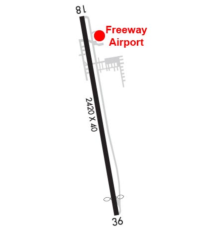
| Lat: N 3856.5 Long: W 07646.3 Elev: 168 Var: +10 Longest Runway: 2420 | ||
| CTAF: 123.07 | ||
| |||||||||||||||||||||||||||||||||||||||||||||||||||||||||||||
| |||||||||||||||||||||||||||||||||||||||||||||||||||||||||||||
| Rwy | Rwy | |||||||
| 2420x40 | 2420' | 2420x40 | 2190' | |||||
| Runway ID | Single Wheel | Double Wheel | Double Tandem Wheel | Dual Double Wheel |
| 18/36 | N/A | N/A | N/A | N/A |
| These numbers are Advisory and are not limits. The Airport Manager should have more accurate Weight Limits | ||||
 Airport Diagram might not be current. | |
| Facility Name: | FREEWAY |
| City Name: | BOWIE |
| County: | PRINCE GEORGES |
| State abbrev: | MD |
| State Name: | MARYLAND |
| Ownership: | PRIVATELY OWNED |
| Use: | OPEN TO THE PUBLIC |
| Owner's Name: | FREEWAY AIRPORT INC. |
| Address: | 3900 CHURCH RD |
| BOWIE, MD 20721 | |
| Owner's Phone: | 301-390-6424 |
| Manager's Name: | MATTHEW LINDQUIST |
| Address: | 3900 CHURCH RD |
| MITCHELLVILLE, MD 20716 | |
| Phone: | 301-390-6424 |
| FAA Region: | EASTERN |
| FAA Field Office: | DCA |
| Date | Sunrise | Sunset |
|---|---|---|
| 06/08/26 Monday | 5:41 | 20:31 |
| 06/09/26 Tuesday | 5:41 | 20:31 |
| 06/10/26 Wednesday | 5:41 | 20:32 |
| 06/11/26 Thursday | 5:41 | 20:32 |
| 06/12/26 Friday | 5:41 | 20:33 |
| 06/13/26 Saturday | 5:41 | 20:33 |
| 06/14/26 Sunday | 5:41 | 20:34 |
| 06/15/26 Monday | 5:41 | 20:34 |
| 06/16/26 Tuesday | 5:41 | 20:35 |
| 06/17/26 Wednesday | 5:41 | 20:35 |
| 06/18/26 Thursday | 5:41 | 20:35 |
| 06/19/26 Friday | 5:41 | 20:35 |
| 06/20/26 Saturday | 5:42 | 20:36 |
| 06/21/26 Sunday | 5:42 | 20:36 |
| Airport Attendance Schedule | 7 Days A Week 0800-1700; UNATNDD MAJOR HOLIDAYS. |
| Airport Status | OPERATIONAL (This Status can change at any time - please check NOTAMS) |
| Airport Lighting Schedule | ACTVT PAPI RWYS 18 & 36; MIRL RWY 18/36 - CTAF. |
| Airport Storage Available | Tie Downs |
| Extra Services Available | Charter, Flight Instruction, Aircraft Rental |
| Wind Indicator | YES - (lighted) |
| Control Tower | NO |
| CTAF Frequency | 123.075 |
| Unicom Frequency | 123.075 |
| Rotating Beacon Color | WG |
| Segmented Circle | YES |
| Landing Fee |
| Airport Inspected | STATE - performed by STATE AERONAUTICAL PERSONNEL |
| Inspection Date | 09/05/2025 |
| Type of Fuel Available | Grade 100LL; -10100LL AVBL WHEN ATNDD. |
| Airframe Repair Service | MAJOR |
| Power Plant Repair Service | MAJOR |
| Latitude | N3856.5 |
| Longitude | W07646.3 (ESTIMATED) |
| Arpt Elevation | 168ft (SURVEYED) |
| Magnetic Variation | 10W |
| 2 miles NW | of BOWIE |
| Traffic Pattern Altitude | |
| Sectional Chart | WASHINGTON |
| Operations (Reported) | Yearly | Avg. Daily |
|---|---|---|
| General Aviation Transient | 0 | 0 |
| General Aviation Local | 0 | 0 |
| Air Taxi | 0 | 0 |
| Commerical | 0 | 0 |
| Commuter | 0 | 0 |
| Military | 0 | 0 |
| Aircraft based on Field | |
|---|---|
| General Aviation Singles | 0 |
| General Aviation Multi | 0 |
| Jet Aircraft | 0 |
| General Aviation Helicopters | 0 |
| Military Aircraft | 0 |
| Gliders | 0 |
| Ultralights | 0 |
| FSS on field | NO |
| FSS tie-in | LEESBURG |
| FSS Phone | 1-800-WX-BRIEF |
| Who issues Notams | DCA |
| Notam D service at airport | YES |
| ARTCC Name | WASHINGTON |
| Airport Certification | |
| Aircraft Rescue & Firefighting Index | None |
| Airport of Entry | No |
| Custom Landing Rights | No |
| Joint Civil/Military | No |
| Military Landing rights | No |
| TPA 1000 FT MSL (832 FT AGL) FOR ACFT LESS THAN 4000 LBS MAX GWT; TPA 1200 FT MSL (1032 FT AGL) FOR ACFT GREATER THAN 4000 LBS. |
| -15 FT DROP 80 FT FROM APCH TO RWY 36. |
| -7 FT DROP 50 FT FM APCH END RWY 18. |
| UNLGTD ANTENNA 135 FT AGL 600 FT NW AER 18. |
| FOR CD CTC POTOMAC APCH AT 866-599-3874. |
| TWY RUNUP AREA FOR RWY 36 CLSD. |
Airport Communications & Frequencies:
| ||||||||||||||
| Runway: 18 | Runway: 36 | ||
| Mag heading: | 180° | Mag heading: | 360° |
| Rwy Slope: | -.68% Down | Rwy Slope: | .68% Up |
| Approach: | Approach: | ||
| Pattern: | Left Traffic | Pattern: | Right Traffic |
| Markings: | NONPRECISION INSTRUMENT | Markings: | NONPRECISION INSTRUMENT |
| Marking Condition: | FAIR | Marking Condition: | FAIR |
| Arresting Dev: | Arresting Dev: | ||
| Lat & Long: | N3856.7 W07646.4 | Lat. & Long.: | N3856.3 W07646.3 |
| Elev: | 168.1 ft. MSL | Elev: | 151.6 ft. MSL |
| TCH: | 47 ft. AGL | TCH: | 26 ft. AGL |
| Visual Glide Path: | 6.00 degrees | Visual Glide Path: | 5.50 degrees |
| Displaced Threshold: | No | Displaced Threshold: | 230 feet |
| Touchdown Zone: | YES | Touchdown Zone: | YES |
| Touchdown Elev.: | 168.1 feet | Touchdown Elev.: | 168.1 feet |
| Visual Glide Slope: | 2-Light PAPI on RIGHT side of Runway | Visual Glide Slope: | 2-Light PAPI on LEFT side of Runway |
| RVR Equipment: | RVR Equipment: | ||
| RVV Equipment: | NO | RVV Equipment: | NO |
| Approach Lights: | Approach Lights: | ||
| REIL: | NO | REIL: | NO |
| Centerline Lights: | NO | Centerline Lights: | NO |
| Touchdown lights: | NO | Touchdown lights: | NO |
| Runway Category: | Runway with a Non-precision Approach | Runway Category: | Runway with a Non-precision Approach |
| Declared Distances: | Declared Distances: | ||
| Obstructions: | TREES | Obstructions: | TREES |
| Marked: | MARKED and LIGHTED | Marked: | NOT Marked/Lighted |
| Clearance slope: | 9:1 | Clearance slope: | 7:1; APCH RATIO 15:1 TO DSPLCD THR AT CNTRLN. |
| Obstruction height: | 67 feet AGL | Obstruction height: | 48 feet AGL |
| Dist. from runway: | 848 feet | Dist. from runway: | 569 feet |
| Centerline offset: | 164 left of centerline | Centerline offset: | 90 feet left of centerline |
| Comments: | +7 FT ROAD AT 115 FT OUT, OB. | Comments: | +18 FT TREES AT 175 FT OUT, 22 FT R. |
Thanks for using FltPlan.com
all rights reserved © 1999-2026 by Flight Plan LLC