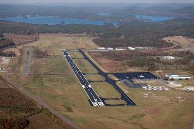
| STANLY COUNTY ALBEMARLE NC |
| |
| Lat: N 3525.0 Long: W 08009.0 Elev: 609 Var: +06 Longest Runway: 5499 | ||
| Clr Del: 121.75 AWOS: 128.17 Ground: 121.75 Tower: 126.27 | ||
| ||||||||||||||||||||||||||||||||||||||||||||
| ||||||||||||||||||||||||||||||||||||||||||||
| ||||||||||||||||||||||||||||||||||||||||||||
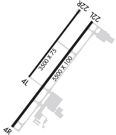
| Rwy | Rwy | |||||||
| 3501x75 | 3501' | 3501x75 | 3501' | |||||
| 5499x100 | 5499' | 5499x100 | 5499' | 110.55 - 223° | ||||
| Runway ID | Single Wheel | Double Wheel | Double Tandem Wheel | Dual Double Wheel |
| 04L/22R | N/A | 130,000 | N/A | N/A |
| 04R/22L | N/A | 130,000 | N/A | N/A |
| These numbers are Advisory and are not limits. The Airport Manager should have more accurate Weight Limits | ||||
 Airport Diagram might not be current. | |
| Facility Name: | STANLY COUNTY |
| City Name: | ALBEMARLE |
| County: | STANLY |
| State abbrev: | NC |
| State Name: | NORTH CAROLINA |
| Ownership: | PUBLICLY OWNED |
| Use: | OPEN TO THE PUBLIC |
| Owner's Name: | STANLY COUNTY |
| Address: | 43222 LOWDER AVIATION PARKWAY |
| NEW LONDON, NC 28127 | |
| Owner's Phone: | 704-982-9013 |
| Manager's Name: | RANDY SHANK |
| Address: | 43222 LOWDER AVIATION PARKWAY |
| NEW LONDON, NC 28127 | |
| Phone: | 704-982-9013 |
| FAA Region: | SOUTHERN |
| FAA Field Office: | MEM |
| Date | Sunrise | Sunset |
|---|---|---|
| 06/12/26 Friday | 6:05 | 20:36 |
| 06/13/26 Saturday | 6:05 | 20:36 |
| 06/14/26 Sunday | 6:05 | 20:37 |
| 06/15/26 Monday | 6:05 | 20:37 |
| 06/16/26 Tuesday | 6:05 | 20:38 |
| 06/17/26 Wednesday | 6:05 | 20:38 |
| 06/18/26 Thursday | 6:05 | 20:38 |
| 06/19/26 Friday | 6:05 | 20:38 |
| 06/20/26 Saturday | 6:06 | 20:39 |
| 06/21/26 Sunday | 6:06 | 20:39 |
| 06/22/26 Monday | 6:06 | 20:39 |
| 06/23/26 Tuesday | 6:06 | 20:39 |
| 06/24/26 Wednesday | 6:06 | 20:39 |
| 06/25/26 Thursday | 6:07 | 20:40 |
| Airport Attendance Schedule | 7 Days A Week 0800-1800 |
| Airport Status | OPERATIONAL (This Status can change at any time - please check NOTAMS) |
| Airport Lighting Schedule | ACTVT REIL RWY 04R & 22L; HIRL RWY 04R/22L; MIRL RWY 04L/22R - CTAF. PAPI RWY 04R & 22L ON DRG TWR OPN, OTHER TIMES - CTAF. |
| Airport Storage Available | Tie Downs, Hanger |
| Extra Services Available | Flight Instruction, Parachute Jumping, Aircraft Rental |
| Wind Indicator | YES - (lighted) |
| Control Tower | YES |
| CTAF Frequency | 126.275 |
| Unicom Frequency | |
| Rotating Beacon Color | WG |
| Segmented Circle | YES |
| Landing Fee | NO |
| Airport Inspected | STATE - performed by STATE AERONAUTICAL PERSONNEL |
| Inspection Date | 05/29/2023 |
| Type of Fuel Available | Grade 100LL, JET A, JET A-1 (icing inhibitor, freeze point -50C); -10100LL AVBL SELF SVC H24 WITH CREDIT CARD. |
| Airframe Repair Service | MAJOR |
| Power Plant Repair Service | MAJOR |
| Latitude | N3525.0 |
| Longitude | W08009.0 (ESTIMATED) |
| Arpt Elevation | 609ft (SURVEYED) |
| Magnetic Variation | 06W |
| 4 miles NE | of ALBEMARLE |
| Traffic Pattern Altitude | TPA: HEL 500 FT (1200 FT MSL), SMALL FW 1000 FT (1700 MSL), LRG/HVY 1500 FT (2200 FT MSL), OVHD 1500 FT (2200 FT MSL) OR AS ASGND BY TWR. |
| Sectional Chart | CHARLOTTE |
| Operations (Reported) | Yearly | Avg. Daily |
|---|---|---|
| General Aviation Transient | 0 | 0 |
| General Aviation Local | 0 | 0 |
| Air Taxi | 0 | 0 |
| Commerical | 0 | 0 |
| Commuter | 0 | 0 |
| Military | 0 | 0 |
| Aircraft based on Field | |
|---|---|
| General Aviation Singles | 0 |
| General Aviation Multi | 0 |
| Jet Aircraft | 0 |
| General Aviation Helicopters | 0 |
| Military Aircraft | 0 |
| Gliders | 0 |
| Ultralights | 0 |
| FSS on field | NO |
| FSS tie-in | RALEIGH |
| FSS Phone | 1-800-WX-BRIEF |
| Who issues Notams | VUJ |
| Notam D service at airport | YES |
| ARTCC Name | ATLANTA |
| Airport Certification | |
| Aircraft Rescue & Firefighting Index | None |
| Airport of Entry | No |
| Custom Landing Rights | No |
| Joint Civil/Military | No |
| Military Landing rights | YES |
| NATIONAL PLAN OF INTEGRATED AIRPORT SYSTEMS (NPIAS) |
| GRANT AGREEMENTS UNDER FAAP/ADAP/AIP |
| ASSURANCES PURSUANT TO TITLE VI, CIVIL RIGHTS ACT OF 1964 |
| 959 FT MSL LGTD TWR 1.5NW. |
| MISC: REGIONAL TRAINING SITE (RTS) SUPPORT COORD THRU 145 AW/CE DSN 231-4229. |
| ANG: PPR ONLY IF UTILIZING ANG RAMP AND FBO RAMP, 235 CAOS/ATM C704-422-2551. |
| HEAVY PARACHUTE JUMPING NORTH END OF RWY 22L/R. |
| FOR CD WHEN ATCT IS CLSD CTC CHARLOTTE APCH AT 704-359-0241. |
| FBO OPERATIONAL HRS 0800-1800. |
| MILITARY FUEL - A+ (C704-982-9013, 1300-0000Z++, OT C704-984-3542 OR C704-961-8964) (NC-100LL). FUEL AVBL FROM FBO 1400-2200Z++, OTHER TIMES PPR, C704-982-9013. |
| RSTD: ANG RAMP RSTD TO MIL USE ONLY WITH PPR. CTC 235 CAOS/ATM DSN 484-2551, C704-422-2551 OR C704-763-4633 AFT DUTY HOURS. |
| CAUTION: BE ALERT FOR HIGH SPEED LOW LEVEL MIL ACFT IN VCNTY. FRQ NGT MIL OPR. FREQ ASSAULT OPS TO RWY 22R. DEER AND BIRD HAZARD. |
Airport Communications & Frequencies:
| |||||||||||||||||||||||||||
| Runway: 04L | Runway: 22R | ||
| Mag heading: | 43° | Mag heading: | 223° |
| Rwy Slope: | -.33% Down | Rwy Slope: | .33% Up |
| Approach: | Approach: | ||
| Pattern: | Left Traffic | Pattern: | Left Traffic |
| Markings: | BASIC | Markings: | BASIC |
| Marking Condition: | GOOD | Marking Condition: | GOOD |
| Arresting Dev: | Arresting Dev: | ||
| Lat & Long: | N3524.9 W08009.2 | Lat. & Long.: | N3525.4 W08008.8 |
| Elev: | 592.3 ft. MSL | Elev: | 580.9 ft. MSL |
| TCH: | TCH: | ||
| Visual Glide Path: | Visual Glide Path: | ||
| Displaced Threshold: | No | Displaced Threshold: | No |
| Touchdown Zone: | YES | Touchdown Zone: | YES |
| Touchdown Elev.: | 592.3 feet | Touchdown Elev.: | 582.7 feet |
| Visual Glide Slope: | Visual Glide Slope: | ||
| RVR Equipment: | RVR Equipment: | ||
| RVV Equipment: | NO | RVV Equipment: | NO |
| Approach Lights: | Approach Lights: | ||
| REIL: | NO | REIL: | NO |
| Centerline Lights: | NO | Centerline Lights: | NO |
| Touchdown lights: | NO | Touchdown lights: | NO |
| Runway Category: | Runway with a Visual Approach | Runway Category: | Runway with a Visual Approach |
| Declared Distances: | Declared Distances: | ||
| Obstructions: | FENCE | Obstructions: | TREES |
| Marked: | NOT Marked/Lighted | Marked: | NOT Marked/Lighted |
| Clearance slope: | 9:1 | Clearance slope: | 18:1 |
| Obstruction height: | 23 feet AGL | Obstruction height: | 32 feet AGL |
| Dist. from runway: | 411 feet | Dist. from runway: | 793 feet |
| Centerline offset: | 301 left of centerline | Centerline offset: | 270 feet right of centerline |
| Comments: | 10 FT HILL 0-200 FT FROM THR 200 FT LEFT OF CNTRLN. | Comments: |
| Runway: 04R | Runway: 22L | ||
| Mag heading: | 43° | Mag heading: | 223° |
| Rwy Slope: | -.57% Down | Rwy Slope: | .57% Up |
| Approach: | Approach: | ILS | |
| Pattern: | Left Traffic | Pattern: | Left Traffic |
| Markings: | PRECISION INSTRUMENT | Markings: | PRECISION INSTRUMENT |
| Marking Condition: | GOOD | Marking Condition: | GOOD |
| Arresting Dev: | Arresting Dev: | ||
| Lat & Long: | N3524.6 W08009.4 | Lat. & Long.: | N3525.3 W08008.7 |
| Elev: | 608.9 ft. MSL | Elev: | 577.3 ft. MSL |
| TCH: | 30 ft. AGL | TCH: | 40 ft. AGL |
| Visual Glide Path: | 3.00 degrees | Visual Glide Path: | 3.00 degrees |
| Displaced Threshold: | No | Displaced Threshold: | No |
| Touchdown Zone: | YES | Touchdown Zone: | YES |
| Touchdown Elev.: | 609.0 feet | Touchdown Elev.: | 584.1 feet |
| Visual Glide Slope: | 2-Light PAPI on LEFT side of Runway | Visual Glide Slope: | 2-Light PAPI on LEFT side of Runway |
| RVR Equipment: | RVR Equipment: | ||
| RVV Equipment: | NO | RVV Equipment: | NO |
| Approach Lights: | Approach Lights: | ||
| REIL: | YES | REIL: | YES |
| Centerline Lights: | NO | Centerline Lights: | NO |
| Touchdown lights: | NO | Touchdown lights: | NO |
| Runway Category: | Runway with a Non-precision Approach having visibility minimums greater than 3/4 mile | Runway Category: | Precision Instrument Runway |
| Declared Distances: | Declared Distances: | ||
| Obstructions: | TREES | Obstructions: | TREES |
| Marked: | NOT Marked/Lighted | Marked: | NOT Marked/Lighted |
| Clearance slope: | 5:1 | Clearance slope: | 29:1 |
| Obstruction height: | 32 feet AGL | Obstruction height: | 137 feet AGL |
| Dist. from runway: | 375 feet | Dist. from runway: | 4194 feet |
| Centerline offset: | 488 left of centerline | Centerline offset: | 176 feet right of centerline |
| Comments: | Comments: |
Thanks for using FltPlan.com
all rights reserved © 1999-2026 by Flight Plan LLC