
| HARTNESS STATE (SPRINGFIELD) SPRINGFIELD VT |
| |
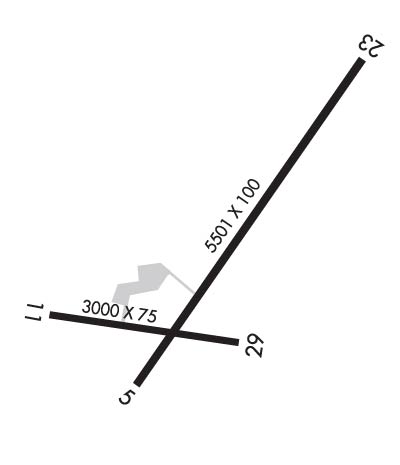
| Lat: N 4320.6 Long: W 07231.0 Elev: 578 Var: +15 Longest Runway: 5501 | ||
| AWOS: 121.42 CTAF: 122.8 | ||
| ||||||
| ||||||
|
| Rwy | Rwy | |||||||
| 5501x100 | 5501' | 111.30 - 051° | 5501x100 | 5501' | ||||
| 3000x75 | 3000' | 3000x75 | 3000' | |||||
| Runway ID | Single Wheel | Double Wheel | Double Tandem Wheel | Dual Double Wheel |
| 05/23 | 32,000 | 45,000 | N/A | N/A |
| 11/29 | 30,000 | N/A | N/A | N/A |
| These numbers are Advisory and are not limits. The Airport Manager should have more accurate Weight Limits | ||||
 Airport Diagram might not be current. | |
| Facility Name: | HARTNESS STATE (SPRINGFIELD) |
| City Name: | SPRINGFIELD |
| County: | WINDSOR |
| State abbrev: | VT |
| State Name: | VERMONT |
| Ownership: | PUBLICLY OWNED |
| Use: | OPEN TO THE PUBLIC |
| Owner's Name: | STATE OF VERMONT |
| Address: | 219 N MAIN ST |
| BARRE, VT 05641 | |
| Owner's Phone: | 802-272-7146 |
| Manager's Name: | CHRIS BEITZEL |
| Address: | 219 N MAIN ST |
| BARRE, VT 05641 | |
| Phone: | 802-272-7725 |
| FAA Region: | NEW ENGLAND |
| FAA Field Office: | NONE |
| Date | Sunrise | Sunset |
|---|---|---|
| 06/08/26 Monday | 5:10 | 20:28 |
| 06/09/26 Tuesday | 5:10 | 20:29 |
| 06/10/26 Wednesday | 5:09 | 20:30 |
| 06/11/26 Thursday | 5:09 | 20:30 |
| 06/12/26 Friday | 5:09 | 20:31 |
| 06/13/26 Saturday | 5:09 | 20:31 |
| 06/14/26 Sunday | 5:09 | 20:32 |
| 06/15/26 Monday | 5:09 | 20:32 |
| 06/16/26 Tuesday | 5:09 | 20:32 |
| 06/17/26 Wednesday | 5:09 | 20:33 |
| 06/18/26 Thursday | 5:09 | 20:33 |
| 06/19/26 Friday | 5:09 | 20:33 |
| 06/20/26 Saturday | 5:09 | 20:34 |
| 06/21/26 Sunday | 5:10 | 20:34 |
| Airport Attendance Schedule | 7 Days A Week 0800-1800; AFT HRS CALL 603-762-8080. |
| Airport Status | OPERATIONAL (This Status can change at any time - please check NOTAMS) |
| Airport Lighting Schedule | ACTVT REIL RWY 05; MIRL RWY 05/23 & 11/29 - CTAF. |
| Airport Storage Available | Tie Downs, Hanger |
| Extra Services Available | Air Freight, Avionics, Charter, Flight Instruction, Aircraft Rental, Glider Towing |
| Wind Indicator | YES - (lighted) |
| Control Tower | NO |
| CTAF Frequency | 122.800 |
| Unicom Frequency | 122.800 |
| Rotating Beacon Color | WG |
| Segmented Circle | NO |
| Landing Fee | NO |
| Airport Inspected | STATE - performed by PRIVATE CONTRACT PERSONNEL |
| Inspection Date | 07/24/2025 |
| Type of Fuel Available | Grade 100LL, JET A (freeze point -40C), JET A; -10FULL & SELF SVC.; -A+FULL SVC ONLY. |
| Airframe Repair Service | MAJOR |
| Power Plant Repair Service | MAJOR |
| Latitude | N4320.6 |
| Longitude | W07231.0 (ESTIMATED) |
| Arpt Elevation | 577ft (SURVEYED) |
| Magnetic Variation | 15W |
| 3 miles NW | of SPRINGFIELD |
| Traffic Pattern Altitude | 1100; 1100 FT AGL SNGL ENG; 1600 FT AGL MULT ENG. |
| Sectional Chart | NEW YORK |
| Operations (Reported) | Yearly | Avg. Daily |
|---|---|---|
| General Aviation Transient | 0 | 0 |
| General Aviation Local | 0 | 0 |
| Air Taxi | 0 | 0 |
| Commerical | 0 | 0 |
| Commuter | 0 | 0 |
| Military | 0 | 0 |
| Aircraft based on Field | |
|---|---|
| General Aviation Singles | 0 |
| General Aviation Multi | 0 |
| Jet Aircraft | 0 |
| General Aviation Helicopters | 0 |
| Military Aircraft | 0 |
| Gliders | 0; GLDRS ON & INVOF ARPT. |
| Ultralights | 0 |
| FSS on field | NO |
| FSS tie-in | BURLINGTON |
| FSS Phone | 1-800-WX-BRIEF |
| Who issues Notams | VSF |
| Notam D service at airport | YES |
| ARTCC Name | BOSTON |
| Airport Certification | |
| Aircraft Rescue & Firefighting Index | None |
| Airport of Entry | No |
| Custom Landing Rights | No |
| Joint Civil/Military | No |
| Military Landing rights | YES |
| NATIONAL PLAN OF INTEGRATED AIRPORT SYSTEMS (NPIAS) |
| GRANT AGREEMENTS UNDER FAAP/ADAP/AIP |
| CONVEYANCE UNDER SCETION 16, FEDERAL AIRPORT ACT OF 1946 OR SECTION 23, AIRPORT AND AIRWAY DEVELOPMENT ACT OF 1970 |
| ASSURANCES PURSUANT TO TITLE VI, CIVIL RIGHTS ACT OF 1964 |
| FOR CD IF UNA TO CTC ON FSS FREQ, CTC BOSTON ARTCC AT 603-879-6859 . |
| RWY CONDS NOT MNT WHEN ARPT IS UNATNDD. |
| BIRDS ON & INVOF ARPT. |
| APN & TWYS A & B ARE PCN S-46 & D-62. |
| NOISE SENSITIVE AREA W OF ARPT. |
| RWY 23 IS CALM WIND RWY IN DAY VFR CONDS. |
| MNTN TPA ON DOWNWIND LEG FOR RWY 05. |
| COLD TEMPERATURE AIRPORT. ALTITUDE CORRECTION REQUIRED AT OR BELOW -19C. |
Airport Communications & Frequencies:
| |||||||||
| Runway: 05 | Runway: 23 | ||
| Mag heading: | 50° | Mag heading: | 230° |
| Rwy Slope: | -.30% Down | Rwy Slope: | .30% Up |
| Approach: | LOC/DME | Approach: | |
| Pattern: | Left Traffic | Pattern: | Left Traffic |
| Markings: | NONPRECISION INSTRUMENT | Markings: | NONPRECISION INSTRUMENT |
| Marking Condition: | FAIR | Marking Condition: | FAIR |
| Arresting Dev: | Arresting Dev: | ||
| Lat & Long: | N4320.3 W07231.3 | Lat. & Long.: | N4321.1 W07230.6 |
| Elev: | 570.9 ft. MSL | Elev: | 554.2 ft. MSL |
| TCH: | 59 ft. AGL | TCH: | |
| Visual Glide Path: | 4.00 degrees | Visual Glide Path: | |
| Displaced Threshold: | No | Displaced Threshold: | No |
| Touchdown Zone: | YES | Touchdown Zone: | YES |
| Touchdown Elev.: | 575.0 feet | Touchdown Elev.: | 565.4 feet |
| Visual Glide Slope: | 4-BOX VASI ON LEFT SIDE OF RUNWAY | Visual Glide Slope: | |
| RVR Equipment: | RVR Equipment: | ||
| RVV Equipment: | NO | RVV Equipment: | NO |
| Approach Lights: | Approach Lights: | ||
| REIL: | YES | REIL: | NO |
| Centerline Lights: | NO | Centerline Lights: | NO |
| Touchdown lights: | NO | Touchdown lights: | NO |
| Runway Category: | Runway with a Non-precision Approach having visibility minimums greater than 3/4 mile | Runway Category: | Runway with a Visual Approach |
| Declared Distances: | Declared Distances: | ||
| Obstructions: | TREES | Obstructions: | TREES |
| Marked: | NOT Marked/Lighted | Marked: | NOT Marked/Lighted |
| Clearance slope: | CTLG OBSTN EXCEEDS 45 DEG SLP. | Clearance slope: | |
| Obstruction height: | 50 feet AGL | Obstruction height: | 50 feet AGL |
| Dist. from runway: | 201 feet | Dist. from runway: | 201 feet |
| Centerline offset: | 214 left of centerline | Centerline offset: | 250 feet right of centerline |
| Comments: | 35 FT TREES, 0-199 FT, 150-250 FT L. | Comments: | 50 FT TREES, 0-200 FT, 135-250 FT L. |
| Runway: 11 | Runway: 29 | ||
| Mag heading: | 114° | Mag heading: | 294° |
| Rwy Slope: | -.24% Down | Rwy Slope: | .24% Up |
| Approach: | Approach: | ||
| Pattern: | Left Traffic | Pattern: | Left Traffic |
| Markings: | BASIC | Markings: | BASIC |
| Marking Condition: | FAIR | Marking Condition: | FAIR |
| Arresting Dev: | Arresting Dev: | ||
| Lat & Long: | N4320.5 W07231.6 | Lat. & Long.: | N4320.4 W07230.9 |
| Elev: | 575.9 ft. MSL | Elev: | 568.8 ft. MSL |
| TCH: | TCH: | ||
| Visual Glide Path: | Visual Glide Path: | ||
| Displaced Threshold: | No | Displaced Threshold: | No |
| Touchdown Zone: | YES | Touchdown Zone: | YES |
| Touchdown Elev.: | 577.5 feet | Touchdown Elev.: | 577.5 feet |
| Visual Glide Slope: | Visual Glide Slope: | ||
| RVR Equipment: | RVR Equipment: | ||
| RVV Equipment: | NO | RVV Equipment: | NO |
| Approach Lights: | Approach Lights: | ||
| REIL: | NO | REIL: | NO |
| Centerline Lights: | NO | Centerline Lights: | NO |
| Touchdown lights: | NO | Touchdown lights: | NO |
| Runway Category: | Runway with a Visual Approach | Runway Category: | Runway with a Visual Approach |
| Declared Distances: | Declared Distances: | ||
| Obstructions: | TREES | Obstructions: | |
| Marked: | NOT Marked/Lighted | Marked: | |
| Clearance slope: | 1:1 | Clearance slope: | 20:1 |
| Obstruction height: | 70 feet AGL | Obstruction height: | |
| Dist. from runway: | 290 feet | Dist. from runway: | |
| Centerline offset: | 155 right of centerline | Centerline offset: | |
| Comments: | Comments: |
Thanks for using FltPlan.com
all rights reserved © 1999-2026 by Flight Plan LLC
