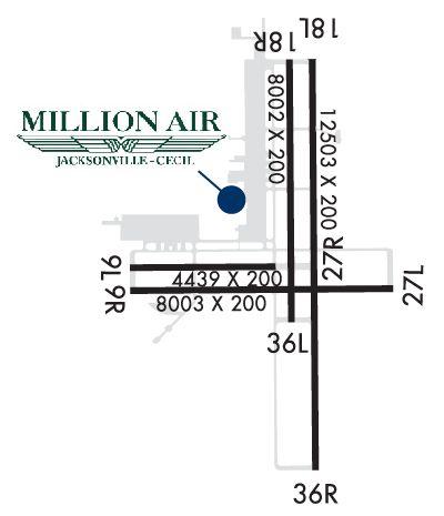
Runway Identification: 09L/27RLength: 4439 ft
Width: 200 ft
Surface: CONCRETE ASPHALT-GOOD CONDITION
Edge lights: Weight: PCN 27 /R/B/X/T
| | Runway: 09L | | Runway: 27R |
| Mag heading: | 95° | Mag heading: | 275° |
| Rwy Slope: | -.18% Down | Rwy Slope: | .18% Up |
| Approach: | | Approach: | |
| Pattern: | Left Traffic | Pattern: | Left Traffic |
| Markings: | BASIC | Markings: | BASIC |
| Marking Condition: | GOOD | Marking Condition: | GOOD |
| Arresting Dev: | | Arresting Dev: | |
| Lat & Long: | N3013.1 W08153.5 | Lat. & Long.: | N3013.1 W08152.7 |
| Elev: | 79.6 ft. MSL | Elev: | 71.5 ft. MSL |
| TCH: | | TCH: | |
| Visual Glide Path: | | Visual Glide Path: | |
| Displaced Threshold: | No | Displaced Threshold: | No |
| Touchdown Zone: | YES | Touchdown Zone: | YES |
| Touchdown Elev.: | 79.6 feet | Touchdown Elev.: | 78.2 feet |
| Visual Glide Slope: | | Visual Glide Slope: | |
| RVR Equipment: | | RVR Equipment: | |
| RVV Equipment: | NO | RVV Equipment: | NO |
| Approach Lights: | | Approach Lights: | |
| REIL: | NO | REIL: | NO |
| Centerline Lights: | NO | Centerline Lights: | NO |
| Touchdown lights: | NO | Touchdown lights: | NO |
| Runway Category: | Runway with a Visual Approach | Runway Category: | Runway with a Visual Approach |
| Declared Distances: | | Declared Distances: | |
| Obstructions: | TREES | Obstructions: | |
| Marked: | NOT Marked/Lighted | Marked: | |
| Clearance slope: | 35:1 | Clearance slope: | 50:1 |
| Obstruction height: | 60 feet AGL | Obstruction height: | |
| Dist. from runway: | 2300 feet | Dist. from runway: | |
| Centerline offset: | 150 left of centerline | Centerline offset: | |
| Comments: | | Comments: | |
Runway Identification: 09R/27LLength: 8003 ft
Width: 200 ft
Surface: CONCRETE ASPHALT-GOOD CONDITION
Edge lights: High IntensityWeight: PCN 21 /F/A/X/T
| | Runway: 09R | | Runway: 27L |
| Mag heading: | 95° | Mag heading: | 275° |
| Rwy Slope: | -.16% Down | Rwy Slope: | .16% Up |
| Approach: | | Approach: | |
| Pattern: | Left Traffic | Pattern: | Left Traffic |
| Markings: | PRECISION INSTRUMENT | Markings: | NONPRECISION INSTRUMENT |
| Marking Condition: | FAIR | Marking Condition: | FAIR |
| Arresting Dev: | | Arresting Dev: | |
| Lat & Long: | N3012.9 W08153.5 | Lat. & Long.: | N3012.9 W08152.0 |
| Elev: | 76.6 ft. MSL | Elev: | 63.9 ft. MSL |
| TCH: | 68 ft. AGL | TCH: | 67 ft. AGL |
| Visual Glide Path: | 3.00 degrees | Visual Glide Path: | 3.00 degrees |
| Displaced Threshold: | No | Displaced Threshold: | No |
| Touchdown Zone: | YES | Touchdown Zone: | YES |
| Touchdown Elev.: | 76.6 feet | Touchdown Elev.: | 71.9 feet |
| Visual Glide Slope: | 4-Light PAPI on LEFT side of Runway | Visual Glide Slope: | 4-Light PAPI on LEFT side of Runway |
| RVR Equipment: | | RVR Equipment: | |
| RVV Equipment: | NO | RVV Equipment: | NO |
| Approach Lights: | MALSR - 1,400 foot medium intensity approach lighting system with runway alignment indicator lights | Approach Lights: | |
| REIL: | NO | REIL: | YES |
| Centerline Lights: | NO | Centerline Lights: | NO |
| Touchdown lights: | NO | Touchdown lights: | NO |
| Runway Category: | D | Runway Category: | Runway with a Non-precision Approach having visibility minimums greater than 3/4 mile |
| Declared Distances: | | Declared Distances: | |
| Obstructions: | TREES | Obstructions: | TREES |
| Marked: | NOT Marked/Lighted | Marked: | NOT Marked/Lighted |
| Clearance slope: | 34:1 | Clearance slope: | 35:1 |
| Obstruction height: | 85 feet AGL | Obstruction height: | 89 feet AGL |
| Dist. from runway: | 3110 feet | Dist. from runway: | 3345 feet |
| Centerline offset: | 100 right of centerline | Centerline offset: | 445 feet left of centerline |
| Comments: | | Comments: | |
Runway Identification: 18L/36RLength: 12503 ft
Width: 200 ft
Surface: CONCRETE ASPHALT-GOOD CONDITION
Edge lights: High IntensityWeight: PCN 28 /R/B/X/T
| | Runway: 18L | | Runway: 36R |
| Mag heading: | 185° | Mag heading: | 5° |
| Rwy Slope: | -.06% Down | Rwy Slope: | .06% Up |
| Approach: | | Approach: | ILS/DME |
| Pattern: | Left Traffic | Pattern: | Left Traffic |
| Markings: | PRECISION INSTRUMENT | Markings: | PRECISION INSTRUMENT |
| Marking Condition: | GOOD | Marking Condition: | GOOD |
| Arresting Dev: | | Arresting Dev: | |
| Lat & Long: | N3014.1 W08152.4 | Lat. & Long.: | N3012.0 W08152.4 |
| Elev: | 79.1 ft. MSL | Elev: | 71.6 ft. MSL |
| TCH: | 66 ft. AGL | TCH: | 66 ft. AGL |
| Visual Glide Path: | 3.00 degrees | Visual Glide Path: | 3.00 degrees |
| Displaced Threshold: | No | Displaced Threshold: | No |
| Touchdown Zone: | YES | Touchdown Zone: | YES |
| Touchdown Elev.: | 79.1 feet | Touchdown Elev.: | 71.8 feet |
| Visual Glide Slope: | 4-Light PAPI on LEFT side of Runway | Visual Glide Slope: | 4-Light PAPI on LEFT side of Runway |
| RVR Equipment: | | RVR Equipment: | |
| RVV Equipment: | NO | RVV Equipment: | NO |
| Approach Lights: | | Approach Lights: | MALSR - 1,400 foot medium intensity approach lighting system with runway alignment indicator lights |
| REIL: | YES | REIL: | NO |
| Centerline Lights: | NO | Centerline Lights: | NO |
| Touchdown lights: | NO | Touchdown lights: | NO |
| Runway Category: | Runway with a Non-precision Approach having visibility minimums greater than 3/4 mile | Runway Category: | Precision Instrument Runway |
| Declared Distances: | | Declared Distances: | |
| Obstructions: | TREES | Obstructions: | TREES |
| Marked: | NOT Marked/Lighted | Marked: | NOT Marked/Lighted |
| Clearance slope: | 40:1 | Clearance slope: | 50:1 |
| Obstruction height: | 74 feet AGL | Obstruction height: | 87 feet AGL |
| Dist. from runway: | 3125 feet | Dist. from runway: | 4595 feet |
| Centerline offset: | 250 left of centerline | Centerline offset: | 500 feet left of centerline |
| Comments: | | Comments: | |
Runway Identification: 18R/36LLength: 8002 ft
Width: 200 ft
Surface: CONCRETE ASPHALT-POOR CONDITION
Edge lights: Weight: PCN 21 /F/A/Y/T
| | Runway: 18R | | Runway: 36L |
| Mag heading: | 184° | Mag heading: | 4° |
| Rwy Slope: | -.11% Down | Rwy Slope: | .11% Up |
| Approach: | | Approach: | |
| Pattern: | Left Traffic | Pattern: | Left Traffic |
| Markings: | PRECISION INSTRUMENT | Markings: | NONPRECISION INSTRUMENT |
| Marking Condition: | FAIR | Marking Condition: | FAIR |
| Arresting Dev: | | Arresting Dev: | |
| Lat & Long: | N3014.1 W08152.6 | Lat. & Long.: | N3012.8 W08152.6 |
| Elev: | 79.3 ft. MSL | Elev: | 70.2 ft. MSL |
| TCH: | | TCH: | |
| Visual Glide Path: | | Visual Glide Path: | |
| Displaced Threshold: | No | Displaced Threshold: | No |
| Touchdown Zone: | YES | Touchdown Zone: | YES |
| Touchdown Elev.: | 79.3 feet | Touchdown Elev.: | 72.0 feet |
| Visual Glide Slope: | | Visual Glide Slope: | |
| RVR Equipment: | | RVR Equipment: | |
| RVV Equipment: | NO | RVV Equipment: | NO |
| Approach Lights: | | Approach Lights: | |
| REIL: | NO | REIL: | NO |
| Centerline Lights: | NO | Centerline Lights: | NO |
| Touchdown lights: | NO | Touchdown lights: | NO |
| Runway Category: | Runway with a Visual Approach | Runway Category: | Runway with a Visual Approach |
| Declared Distances: | | Declared Distances: | |
| Obstructions: | TREES | Obstructions: | |
| Marked: | NOT Marked/Lighted | Marked: | |
| Clearance slope: | 49:1 | Clearance slope: | 50:1 |
| Obstruction height: | 64 feet AGL | Obstruction height: | |
| Dist. from runway: | 3290 feet | Dist. from runway: | |
| Centerline offset: | | Centerline offset: | |
| Comments: | | Comments: | |
Runway Identification: H1 HELIPADLength: 70 ft
Width: 70 ft
Surface: CONCRETE-GOOD CONDITION
Edge lights:
Runway Identification: H2 HELIPADLength: 70 ft
Width: 70 ft
Surface: CONCRETE-GOOD CONDITION
Edge lights: