
| VAN NUYS VAN NUYS CA |
| |
| Lat: N 3412.6 Long: W 11829.4 Elev: 802 Var: -12 Longest Runway: 8001 | ||
| Clr Del: 126.6 Dept. ATIS: 127.55 Arr. ATIS: 127.55 Ground: 121.7 Tower: 119.3/120.2 | ||

| |||||||||||||||||||||||||||||||||||||||||||||||||||||||||||||||||||||
| |||||||||||||||||||||||||||||||||||||||||||||||||||||||||||||||||||||
| |||||||||||||||||||||||||||||||||||||||||||||||||||||||||||||||||||||
| |||||||||||||||||||||||||||||||||||||||||||||||||||||||||||||||||||||
| |||||||||||||||||||||||||||||||||||||||||||||||||||||||||||||||||||||
| |||||||||||||||||||||||||||||||||||||||||||||||||||||||||||||||||||||
| |||||||||||||||||||||||||||||||||||||||||||||||||||||||||||||||||||||
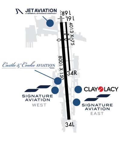
| Rwy | Rwy | |||||||
| 4013x75 | 2579' | 4013x75 | 4013' | |||||
| 8001x150 | 6569' | 111.30 - 163° | 8001x150 | 8001' | ||||
| Runway ID | Single Wheel | Double Wheel | Double Tandem Wheel | Dual Double Wheel |
| 16L/34R | 14,000 | N/A | N/A | N/A |
| 16R/34L | 90,000 | 120,000 | 210,000 | N/A |
| These numbers are Advisory and are not limits. The Airport Manager should have more accurate Weight Limits | ||||
 Airport Diagram might not be current. | |
| Facility Name: | VAN NUYS |
| City Name: | VAN NUYS |
| County: | LOS ANGELES |
| State abbrev: | CA |
| State Name: | CALIFORNIA |
| Ownership: | PUBLICLY OWNED |
| Use: | OPEN TO THE PUBLIC |
| Owner's Name: | LOS ANGELES WORLD ARPTS |
| Address: | 1 WORLD WAY |
| LOS ANGELES, CA 90045 | |
| Owner's Phone: | (818) 442-6540 |
| Manager's Name: | FLORA MARGHERITIS; CHIEF OF AIRPORT OPERATIONS: CHRISTIAN MORENO 818-442-6506. |
| Address: | 16461 SHERMAN WY SUITE 300 |
| VAN NUYS, CA 91406 | |
| Phone: | 818-442-6500 |
| FAA Region: | WESTERN-PACIFIC |
| FAA Field Office: | LAX |
| Date | Sunrise | Sunset |
|---|---|---|
| 09/24/21 Friday | 6:43 | 18:48 |
| 09/25/21 Saturday | 6:44 | 18:47 |
| 09/26/21 Sunday | 6:45 | 18:45 |
| 09/27/21 Monday | 6:45 | 18:44 |
| 09/28/21 Tuesday | 6:46 | 18:42 |
| 09/29/21 Wednesday | 6:47 | 18:41 |
| 09/30/21 Thursday | 6:48 | 18:40 |
| 10/01/21 Friday | 6:48 | 18:38 |
| 10/02/21 Saturday | 6:49 | 18:37 |
| 10/03/21 Sunday | 6:50 | 18:36 |
| 10/04/21 Monday | 6:51 | 18:34 |
| 10/05/21 Tuesday | 6:51 | 18:33 |
| 10/06/21 Wednesday | 6:52 | 18:32 |
| 10/07/21 Thursday | 6:53 | 18:30 |
| Airport Attendance Schedule | CONTINUOUS |
| Airport Status | OPERATIONAL (This Status can change at any time - please check NOTAMS) |
| Airport Lighting Schedule | WHEN ATCT CLSD ACTVT HIRL RY 16R/34L, MALSR RY 16R AND TWY LGTS - CTAF. |
| Airport Storage Available | Tie Downs, Hanger |
| Extra Services Available | Air Ambulance, Avionics, Charter, Flight Instruction, Aircraft Rental, Aircraft Sales, Annual Surveying |
| Wind Indicator | YES - (lighted) |
| Control Tower | YES |
| CTAF Frequency | 119.300 |
| Unicom Frequency | 122.950 |
| Rotating Beacon Color | CLEAR-GREEN (Light Land Airport) |
| Segmented Circle | NO |
| Landing Fee | NO |
| Airport Inspected | STATE - performed by STATE AERONAUTICAL PERSONNEL |
| Inspection Date | 10/23/2018 |
| Type of Fuel Available | Grade 100LL, JET A (freeze point -40C) |
| Airframe Repair Service | MAJOR |
| Power Plant Repair Service | MAJOR |
| Latitude | N3412.6 |
| Longitude | W11829.4 (ESTIMATED) |
| Arpt Elevation | 802ft (SURVEYED) |
| Magnetic Variation | 12E |
| 3 miles NW | of VAN NUYS |
| Traffic Pattern Altitude | TPA RWY 16R/34L 1200'; RWY 16L/34R 1000'. |
| Sectional Chart | LOS ANGELES |
| Operations (Reported) | Yearly | Avg. Daily |
|---|---|---|
| General Aviation Transient | 127083 | 348 |
| General Aviation Local | 69243 | 190 |
| Air Taxi | 27523 | 75 |
| Commerical | 96 | 0 |
| Commuter | 0 | 0 |
| Military | 557 | 2 |
| Aircraft based on Field | |
|---|---|
| General Aviation Singles | 126 |
| General Aviation Multi | 32 |
| Jet Aircraft | 62 |
| General Aviation Helicopters | 20 |
| Military Aircraft | 3 |
| Gliders | 0 |
| Ultralights | 0 |
| FSS on field | NO |
| FSS tie-in | HAWTHORNE |
| FSS Phone | 1-800-WX-BRIEF |
| Who issues Notams | VNY |
| Notam D service at airport | YES |
| ARTCC Name | LOS ANGELES |
| Airport Certification | |
| Aircraft Rescue & Firefighting Index | None |
| Airport of Entry | No |
| Custom Landing Rights | No; US CUSTOMS USER FEE ARPT. |
| Joint Civil/Military | No |
| Military Landing rights | YES |
| NATIONAL PLAN OF INTEGRATED AIRPORT SYSTEMS (NPIAS) |
| GRANT AGREEMENTS UNDER FAAP/ADAP/AIP |
| SURPLUS PROPERTY AGREEMENT UNDER PUBLIC LAW 289 |
| ASSURANCES PURSUANT TO TITLE VI, CIVIL RIGHTS ACT OF 1964 |
| THIS AIRPORT HAS BEEN SURVEYED BY THE NATIONAL GEODETIC SURVEY. |
| ARPT CLSD TO AIR CARRIER OPNS. |
| FORMATION ARRIVALS AND DEPARTURES PROHIBITED EXCEPT FOR EMERGENCY RESPONSE AIRCRAFT. |
| ALL JET ACFT MUST USE FULL RUNWAY LENGTH FOR DEPARTURE UNLESS OTHERWISE DIRECTED BY ATCT. |
| TAXILANE ALPHA 4 RESTRICTED TO ACFT WITH WINGSPANS 100 FT OR LESS.. |
| HEL CONTACT ATCT FOR APCH-DEP ROUTES; |
| BIRD ABATEMENT MAY OCCUR BTN RYS WHEN ATCT IS OPEN. |
| WHEN ATCT CLSD, AIRCRAFT MUST SELF ANNOUNCE ON FREQ 119.3 PRIOR TO LANDING OR DEPARTING. |
| TAXILANE A3 WESTBOUND TAXI ONLY. TAXILANE A2 EASTBOUND TAXI ONLY. TAXILANE A2/A3 HAVE UNIDIRECTIONAL CENTERLINE LIGHTS. |
| RWYS 16L AND 16R: NO TURNS BFR THE FLOOD BASIN, UNLESS DCTC BY ATC. |
| RWYS 34L AND 34R: NO TURNS BEFORE RCHG 1800 FT MSL, UNLESS DCTD BY ATC. |
| RY 16L/34R CLSD & UNLGTD WHEN TOWER CLOSED. |
| NO ACFT MAY ARRIVE OR DEPART THE ARPT WHOSE AC36-3 TKOF NOISE LEVEL EQUALS OR EXCEEDS 77 DBA. |
| TXL A1 WB TAXI ONLY. |
| FOR CD WHEN ATCT CLSD CTC SOCAL APCH AT 800-448-3724. |
| JETS: AVOID DEP AND ARR BTN 11 PM AND 7 AM TO RDC NOISE OVER COMMUNITY. |
| EXTREME NOISE SENSITIVE AREA. |
| NOISE ORDINANCE CURFEW: NO TKOFS FOR ACFT EXCEEDING 74 DBA (PER AC36-3) BTN 2200-0700; EXCP MILITARY; MERCY FLIGHTS & LAW ENFORCEMENT ACFT. |
Airport Communications & Frequencies:
| ||||||||||||||||||||||||||||||||||||||||||||||||||||||||||||||||||||||
| Runway: 16L | Runway: 34R | ||
| Mag heading: | 164° | Mag heading: | 344° |
| Rwy Slope: | -.70% Down | Rwy Slope: | .70% Up |
| Approach: | Approach: | ||
| Pattern: | Left Traffic | Pattern: | Right Traffic |
| Markings: | BASIC | Markings: | BASIC |
| Marking Condition: | FAIR | Marking Condition: | FAIR |
| Arresting Dev: | Arresting Dev: | ||
| Lat & Long: | N3413.1 W11829.4 | Lat. & Long.: | N3412.5 W11829.3 |
| Elev: | 799.8 ft. MSL | Elev: | 771.7 ft. MSL |
| TCH: | TCH: | 26 ft. AGL | |
| Visual Glide Path: | Visual Glide Path: | 3.00 degrees | |
| Displaced Threshold: | 1434 feet | Displaced Threshold: | No |
| Touchdown Zone: | YES | Touchdown Zone: | YES |
| Touchdown Elev.: | 799.8 feet | Touchdown Elev.: | 794.3 feet |
| Visual Glide Slope: | Visual Glide Slope: | 4-BOX VASI ON LEFT SIDE OF RUNWAY | |
| RVR Equipment: | RVR Equipment: | ||
| RVV Equipment: | NO | RVV Equipment: | NO |
| Approach Lights: | Approach Lights: | ||
| REIL: | NO | REIL: | NO |
| Centerline Lights: | NO | Centerline Lights: | NO |
| Touchdown lights: | NO | Touchdown lights: | NO |
| Runway Category: | Runway with a Visual Approach | Runway Category: | Runway with a Visual Approach |
| Declared Distances: | TORA:4013' TODA:4013' ASDA:4013' LDA:2582' | Declared Distances: | TORA:4013' TODA:4013' ASDA:3906' LDA:3906' |
| Obstructions: | RR | Obstructions: | |
| Marked: | LIGHTED | Marked: | |
| Clearance slope: | 2:1; RWY 16L APCH RATIO 53:1 FM DISPLCD THLD | Clearance slope: | 50:1 |
| Obstruction height: | 32 feet AGL | Obstruction height: | |
| Dist. from runway: | 275 feet | Dist. from runway: | |
| Centerline offset: | 125 left of centerline | Centerline offset: | |
| Comments: | Comments: |
| Runway: 16R | Runway: 34L | ||
| Mag heading: | 164° | Mag heading: | 344° |
| Rwy Slope: | -.70% Down | Rwy Slope: | .70% Up |
| Approach: | ILS | Approach: | |
| Pattern: | Right Traffic; LEFT TFC WHEN ATCT CLSD. | Pattern: | Left Traffic |
| Markings: | PRECISION INSTRUMENT | Markings: | PRECISION INSTRUMENT |
| Marking Condition: | GOOD | Marking Condition: | GOOD |
| Arresting Dev: | Arresting Dev: | ||
| Lat & Long: | N3413.1 W11829.5 | Lat. & Long.: | N3411.8 W11829.4 |
| Elev: | 802.1 ft. MSL | Elev: | 745.7 ft. MSL |
| TCH: | 50 ft. AGL | TCH: | 54 ft. AGL |
| Visual Glide Path: | 3.50 degrees | Visual Glide Path: | 3.00 degrees |
| Displaced Threshold: | 1432 feet | Displaced Threshold: | No |
| Touchdown Zone: | YES | Touchdown Zone: | YES |
| Touchdown Elev.: | 793.3 feet | Touchdown Elev.: | 767.3 feet |
| Visual Glide Slope: | PULSATING/STEADY BURNING VASI ON LEFT SIDE OF RUNWAY; UNUSBL BYD 6.8 NM DUE TO TRRN. UNUSBL BYD 8 DEG LEFT & 6 DEG RIGHT OF RWY CNTRLN. | Visual Glide Slope: | 4-Light PAPI on RIGHT side of Runway |
| RVR Equipment: | TOUCHDOWN | RVR Equipment: | |
| RVV Equipment: | NO | RVV Equipment: | NO |
| Approach Lights: | MALSR - 1,400 foot medium intensity approach lighting system with runway alignment indicator lights | Approach Lights: | |
| REIL: | NO | REIL: | NO |
| Centerline Lights: | NO | Centerline Lights: | NO |
| Touchdown lights: | NO | Touchdown lights: | NO |
| Runway Category: | Precision Instrument Runway | Runway Category: | Runway with a Visual Approach |
| Declared Distances: | TORA:8001' TODA:8001' ASDA:8001' LDA:6570' | Declared Distances: | TORA:8001' TODA:8001' ASDA:7261' LDA:7261' |
| Obstructions: | FENCE | Obstructions: | TREES |
| Marked: | LIGHTED | Marked: | NOT Marked/Lighted |
| Clearance slope: | APCH RATIO 50:1 FM DSPLCD THLD. APCH RATIO TO DSPLCD THLD OVER +41 FT RR 1700 FT FM DSPLCD THLD 500 FT LEFT 41:1. | Clearance slope: | 33:1 |
| Obstruction height: | 17 feet AGL | Obstruction height: | 30 feet AGL |
| Dist. from runway: | 200 feet | Dist. from runway: | 1200 feet |
| Centerline offset: | 175 right of centerline | Centerline offset: | 75 feet left of centerline |
| Comments: | Comments: |
Thanks for using FltPlan.com
all rights reserved © 1999-2021 by Flight Plan LLC