| VAN WERT COUNTY VAN WERT OH |
| |
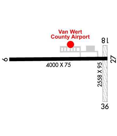
| Lat: N 4051.8 Long: W 08436.5 Elev: 787 Var: +05 Longest Runway: 5005 | ||
| AWOS: 125.17 CTAF: 123.0 | ||
| |||||||||||||||||||||||||||||||||||||||||||||||||||||||||||||
| |||||||||||||||||||||||||||||||||||||||||||||||||||||||||||||
| |||||||||||||||||||||||||||||||||||||||||||||||||||||||||||||
| Rwy | Rwy | |||||||
| 5005x75 | 5005' | 5005x75 | 5005' | |||||
| 2558x95 | 2219' | 2558x95 | 1866' | |||||
| Runway ID | Single Wheel | Double Wheel | Double Tandem Wheel | Dual Double Wheel |
| 09/27 | 8,000 | N/A | N/A | N/A |
| 18/36 | N/A | N/A | N/A | N/A |
| These numbers are Advisory and are not limits. The Airport Manager should have more accurate Weight Limits | ||||
 Airport Diagram might not be current. | |
| Facility Name: | VAN WERT COUNTY |
| City Name: | VAN WERT |
| County: | VAN WERT |
| State abbrev: | OH |
| State Name: | OHIO |
| Ownership: | PUBLICLY OWNED |
| Use: | OPEN TO THE PUBLIC |
| Owner's Name: | VAN WERT CO RGNL ARPT AUTH |
| Address: | 901 ELKS DR |
| VAN WERT, OH 45891-8202 | |
| Owner's Phone: | 419-232-4500 |
| Manager's Name: | JAMES BLACK |
| Address: | 901 ELKS DR |
| VAN WERT, OH 45891-8202 | |
| Phone: | 419-232-4500 |
| FAA Region: | GREAT LAKES |
| FAA Field Office: | DET |
| Date | Sunrise | Sunset |
|---|---|---|
| 06/08/26 Monday | 6:07 | 21:08 |
| 06/09/26 Tuesday | 6:07 | 21:09 |
| 06/10/26 Wednesday | 6:06 | 21:09 |
| 06/11/26 Thursday | 6:06 | 21:10 |
| 06/12/26 Friday | 6:06 | 21:10 |
| 06/13/26 Saturday | 6:06 | 21:11 |
| 06/14/26 Sunday | 6:06 | 21:11 |
| 06/15/26 Monday | 6:06 | 21:12 |
| 06/16/26 Tuesday | 6:06 | 21:12 |
| 06/17/26 Wednesday | 6:06 | 21:12 |
| 06/18/26 Thursday | 6:06 | 21:13 |
| 06/19/26 Friday | 6:06 | 21:13 |
| 06/20/26 Saturday | 6:07 | 21:13 |
| 06/21/26 Sunday | 6:07 | 21:14 |
| Airport Attendance Schedule | MON-FRI 0730-1600, SAT-SUN BY PRIOR ARNGMT |
| Airport Status | OPERATIONAL (This Status can change at any time - please check NOTAMS) |
| Airport Lighting Schedule | ACTVT REIL RWY 09 & 27; PAPI RWY 09 & 27; MIRL RWY 09/27 - CTAF. TWY LGTS AT ENTRANCE TO RWY 09/27. |
| Airport Storage Available | Tie Downs |
| Extra Services Available | Flight Instruction, Aircraft Rental |
| Wind Indicator | YES - (lighted) |
| Control Tower | NO |
| CTAF Frequency | 123.000 |
| Unicom Frequency | 123.000 |
| Rotating Beacon Color | WG |
| Segmented Circle | NO |
| Landing Fee | NO |
| Airport Inspected | STATE - performed by STATE AERONAUTICAL PERSONNEL |
| Inspection Date | 08/29/2023 |
| Type of Fuel Available | Grade 100LL, JET A |
| Airframe Repair Service | MINOR |
| Power Plant Repair Service | MINOR |
| Latitude | N4051.8 |
| Longitude | W08436.5 (ESTIMATED) |
| Arpt Elevation | 786ft (SURVEYED) |
| Magnetic Variation | 05W |
| 1 miles WSW | of VAN WERT |
| Traffic Pattern Altitude | 812 |
| Sectional Chart | DETROIT |
| Operations (Reported) | Yearly | Avg. Daily |
|---|---|---|
| General Aviation Transient | 0 | 0 |
| General Aviation Local | 0 | 0 |
| Air Taxi | 0 | 0 |
| Commerical | 0 | 0 |
| Commuter | 0 | 0 |
| Military | 0 | 0 |
| Aircraft based on Field | |
|---|---|
| General Aviation Singles | 0 |
| General Aviation Multi | 0 |
| Jet Aircraft | 0 |
| General Aviation Helicopters | 0 |
| Military Aircraft | 0 |
| Gliders | 0 |
| Ultralights | 0 |
| FSS on field | NO |
| FSS tie-in | DAYTON |
| FSS Phone | 1-800-WX-BRIEF |
| Who issues Notams | VNW |
| Notam D service at airport | YES |
| ARTCC Name | INDIANAPOLIS |
| Airport Certification | |
| Aircraft Rescue & Firefighting Index | None |
| Airport of Entry | No |
| Custom Landing Rights | No |
| Joint Civil/Military | No |
| Military Landing rights | YES |
| NATIONAL PLAN OF INTEGRATED AIRPORT SYSTEMS (NPIAS) |
| GRANT AGREEMENTS UNDER FAAP/ADAP/AIP |
| ASSURANCES PURSUANT TO TITLE VI, CIVIL RIGHTS ACT OF 1964 |
| FOR CD CTC CHICAGO ARTCC AT 630-906-8921. |
| ULTRALIGHTS OPR EVES, WKENDS, & IN NO-WIND CONDS. |
Airport Communications & Frequencies:
| |||||||||||||||||||||||||||
| Runway: 09 | Runway: 27 | ||
| Mag heading: | 95° | Mag heading: | 275° |
| Rwy Slope: | .05% Up | Rwy Slope: | -.05% Down |
| Approach: | Approach: | ||
| Pattern: | Left Traffic | Pattern: | Left Traffic |
| Markings: | NONPRECISION INSTRUMENT | Markings: | NONPRECISION INSTRUMENT |
| Marking Condition: | GOOD | Marking Condition: | GOOD |
| Arresting Dev: | Arresting Dev: | ||
| Lat & Long: | N4051.9 W08437.2 | Lat. & Long.: | N4051.9 W08436.1 |
| Elev: | 782.8 ft. MSL | Elev: | 785.1 ft. MSL |
| TCH: | 38 ft. AGL | TCH: | 38 ft. AGL |
| Visual Glide Path: | 3.00 degrees | Visual Glide Path: | 3.50 degrees |
| Displaced Threshold: | No | Displaced Threshold: | No |
| Touchdown Zone: | YES | Touchdown Zone: | YES |
| Touchdown Elev.: | 784.0 feet | Touchdown Elev.: | 785.6 feet |
| Visual Glide Slope: | 4-Light PAPI on LEFT side of Runway | Visual Glide Slope: | 4-Light PAPI on LEFT side of Runway |
| RVR Equipment: | RVR Equipment: | ||
| RVV Equipment: | NO | RVV Equipment: | NO |
| Approach Lights: | Approach Lights: | ||
| REIL: | YES | REIL: | YES |
| Centerline Lights: | NO | Centerline Lights: | NO |
| Touchdown lights: | NO | Touchdown lights: | NO |
| Runway Category: | Runway with a Non-precision Approach | Runway Category: | Runway with a Non-precision Approach |
| Declared Distances: | Declared Distances: | ||
| Obstructions: | Obstructions: | CROPS | |
| Marked: | Marked: | NOT Marked/Lighted | |
| Clearance slope: | 20:1 | Clearance slope: | OBSTN CLNC SLP 0:1 TO THR OVR + 3FT CROPS, 201 FT DIST, 245 FT L. |
| Obstruction height: | Obstruction height: | 3 feet AGL | |
| Dist. from runway: | Dist. from runway: | 201 feet | |
| Centerline offset: | Centerline offset: | 245 feet left of centerline | |
| Comments: | Comments: | OBSTN CLNC SLP 0:1 TO THR OVR +3 FT CROPS, 0-200 FT DIST, 245 FT L. |
| Runway: 18 | Runway: 36 | ||
| Mag heading: | 184° | Mag heading: | 4° |
| Rwy Slope: | .17% Up | Rwy Slope: | -.17% Down |
| Approach: | Approach: | ||
| Pattern: | Left Traffic | Pattern: | Left Traffic |
| Markings: | Markings: | ||
| Marking Condition: | DTHR MKD. | Marking Condition: | DTHR MKD. |
| Arresting Dev: | Arresting Dev: | ||
| Lat & Long: | N4052.0 W08436.1 | Lat. & Long.: | N4051.5 W08436.1 |
| Elev: | 781.8 ft. MSL | Elev: | 786.1 ft. MSL |
| TCH: | TCH: | ||
| Visual Glide Path: | Visual Glide Path: | ||
| Displaced Threshold: | 339 feet | Displaced Threshold: | 692 feet |
| Touchdown Zone: | YES | Touchdown Zone: | YES |
| Touchdown Elev.: | 786.9 feet | Touchdown Elev.: | 786.9 feet |
| Visual Glide Slope: | Visual Glide Slope: | ||
| RVR Equipment: | RVR Equipment: | ||
| RVV Equipment: | NO | RVV Equipment: | NO |
| Approach Lights: | Approach Lights: | ||
| REIL: | NO | REIL: | NO |
| Centerline Lights: | NO | Centerline Lights: | NO |
| Touchdown lights: | NO | Touchdown lights: | NO |
| Runway Category: | Runway with a Visual Approach | Runway Category: | Runway with a Visual Approach |
| Declared Distances: | Declared Distances: | ||
| Obstructions: | TREE; ALSO ROAD, TREES, & BLDGS. | Obstructions: | ROAD; ALSO ROADS, TREES, & BLDGS. |
| Marked: | NOT Marked/Lighted | Marked: | NOT Marked/Lighted |
| Clearance slope: | 3:1; OBSTN CLNC SLP 8:1 TO DTHR OVR +60 FT TREE, 521 FT DIST, 45 FT L. | Clearance slope: | 1:1; OBST CLNC SLP 0:1 TO DTHR DUE TO +3 FT CROPS, 40 FT L/R. |
| Obstruction height: | 60 feet AGL | Obstruction height: | 15 feet AGL |
| Dist. from runway: | 220 feet | Dist. from runway: | 20 feet |
| Centerline offset: | 45 left of centerline | Centerline offset: | 125B |
| Comments: | Comments: |
Thanks for using FltPlan.com
all rights reserved © 1999-2026 by Flight Plan LLC