| VALDOSTA RGNL VALDOSTA GA |
| |
| Lat: N 3046.9 Long: W 08316.6 Elev: 203 Var: +05 Longest Runway: 8002 | ||
| AWOS: 126.22 Ground: 121.7 Tower: 120.9 | ||
| ||||||||||||||||||||||||||||||||||||||||||||||||||||||||||||||||||||
| ||||||||||||||||||||||||||||||||||||||||||||||||||||||||||||||||||||
| ||||||||||||||||||||||||||||||||||||||||||||||||||||||||||||||||||||
| Rwy | Rwy | |||||||
| 5598x100 | 5598' | 5598x100 | 5598' | |||||
| 3636x75 | 3636' | 3636x75 | 3636' | |||||
| 8002x150 | 8002' | 8002x150 | 8002' | 110.90 - 355° | ||||
| Runway ID | Single Wheel | Double Wheel | Double Tandem Wheel | Dual Double Wheel |
| 04/22 | 24,000 | 95,000 | N/A | N/A |
| 13/31 | 24,000 | 155,000 | N/A | N/A |
| 17/35 | 104,000 | 169,000 | 303,000 | N/A |
| These numbers are Advisory and are not limits. The Airport Manager should have more accurate Weight Limits | ||||
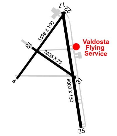 Airport Diagram might not be current. | |
| Facility Name: | VALDOSTA RGNL |
| City Name: | VALDOSTA |
| County: | LOWNDES |
| State abbrev: | GA |
| State Name: | GEORGIA |
| Ownership: | PUBLICLY OWNED |
| Use: | OPEN TO THE PUBLIC |
| Owner's Name: | VALDOSTA-LOWNDES CTY APT AUTH |
| Address: | 1750 ARPT RD, SUITE 1 |
| VALDOSTA, GA 31601 | |
| Owner's Phone: | 229-333-1833 |
| Manager's Name: | JIM GALLOWAY |
| Address: | 1750 AIRPORT ROAD, SUITE 1 |
| VALDOSTA, GA 31601 | |
| Phone: | 229-333-1833 |
| FAA Region: | SOUTHERN |
| FAA Field Office: | ATL |
| Date | Sunrise | Sunset |
|---|---|---|
| 09/24/21 Friday | 7:22 | 19:27 |
| 09/25/21 Saturday | 7:23 | 19:26 |
| 09/26/21 Sunday | 7:24 | 19:25 |
| 09/27/21 Monday | 7:24 | 19:24 |
| 09/28/21 Tuesday | 7:25 | 19:22 |
| 09/29/21 Wednesday | 7:25 | 19:21 |
| 09/30/21 Thursday | 7:26 | 19:20 |
| 10/01/21 Friday | 7:27 | 19:19 |
| 10/02/21 Saturday | 7:27 | 19:17 |
| 10/03/21 Sunday | 7:28 | 19:16 |
| 10/04/21 Monday | 7:28 | 19:15 |
| 10/05/21 Tuesday | 7:29 | 19:14 |
| 10/06/21 Wednesday | 7:30 | 19:12 |
| 10/07/21 Thursday | 7:30 | 19:11 |
| Airport Attendance Schedule | 7 Days A Week 0600-2200; CONTACT FBO 229-242-3175. |
| Airport Status | OPERATIONAL (This Status can change at any time - please check NOTAMS) |
| Airport Lighting Schedule | WHEN ATCT CLSD ACTVT MALSR RWY 35; REIL RWY 17; PAPI RWY 17/35; HIRL RWY 17/35 - CTAF. REIL RWY 04/22; PAPI RWY 04/22; MIRL RWY 04/22, 13/31 UNAVBL WHEN ATCT CLSD. |
| Airport Storage Available | Tie Downs, Hanger |
| Extra Services Available | Air Ambulance, Flight Instruction, Aircraft Rental |
| Wind Indicator | YES - (lighted) |
| Control Tower | YES |
| CTAF Frequency | 120.900 |
| Unicom Frequency | 122.950 |
| Rotating Beacon Color | CLEAR-GREEN (Light Land Airport) |
| Segmented Circle | YES |
| Landing Fee | NO |
| Airport Inspected | FEDERAL - performed by FAA AIRPORTS FIELD PERSONNEL |
| Inspection Date | 04/30/2021 |
| Type of Fuel Available | Grade 100LL, JET A-1 (icing inhibitor, freeze point -50C) |
| Airframe Repair Service | MAJOR |
| Power Plant Repair Service | MAJOR |
| Latitude | N3046.9 |
| Longitude | W08316.6 (ESTIMATED) |
| Arpt Elevation | 203ft (SURVEYED) |
| Magnetic Variation | 05W |
| 3 miles S | of VALDOSTA |
| Traffic Pattern Altitude | |
| Sectional Chart | JACKSONVILLE |
| Operations (Reported) | Yearly | Avg. Daily |
|---|---|---|
| General Aviation Transient | 8281 | 23 |
| General Aviation Local | 7406 | 20 |
| Air Taxi | 2420 | 7 |
| Commerical | 6 | 0 |
| Commuter | 0 | 0 |
| Military | 3648 | 10 |
| Aircraft based on Field | |
|---|---|
| General Aviation Singles | 41 |
| General Aviation Multi | 11 |
| Jet Aircraft | 7 |
| General Aviation Helicopters | 1 |
| Military Aircraft | 0 |
| Gliders | 0 |
| Ultralights | 0 |
| FSS on field | NO |
| FSS tie-in | MACON |
| FSS Phone | 1-800-WX-BRIEF |
| Who issues Notams | VLD |
| Notam D service at airport | YES |
| ARTCC Name | JACKSONVILLE |
| Airport Certification | AIRPORT RECEIVING SCHEDULED AIR CARRIER SERVICE FROM CARRIERS CERTIFICATED BY THE CIVIL AERONAUTICS BOARD; CLSD TO UNSKED ACR OPNS WITH MORE THAN 30 PSGR SEATS EXCP 24 HR PPR CALL AMGR 229-333-1833. |
| Aircraft Rescue & Firefighting Index | AIRPORT HAS A CERTIFICATE UNDER CFR PART 139 |
| Airport of Entry | No |
| Custom Landing Rights | No |
| Joint Civil/Military | No |
| Military Landing rights | YES |
| NATIONAL PLAN OF INTEGRATED AIRPORT SYSTEMS (NPIAS) |
| GRANT AGREEMENTS UNDER FAAP/ADAP/AIP |
| SURPLUS PROPERTY AGREEMENT UNDER REGULATION 16-WAA |
| ASSURANCES PURSUANT TO TITLE VI, CIVIL RIGHTS ACT OF 1964 |
| AGREEMENT UNDER DLAND OR DCLA HAS EXPIRED. |
| RY 04/22 HAS 10FT PAVED SHOULDERS WITH VEGETATION; RY 13/31 HAS 37.5 FT PAVED SHOULDERS. |
| RY 13/31 CLSD TO ACR. |
| RY 13/31 NW 860 FT NOT VISIBLE FROM THE TWR DUE TO TREES. |
| PILOTS MUST SUPPLY OWN TIED DOWN ROPES |
| RWY 13/3 1 RWY 13/31 NOT AVBL FOR SKED ACR OPNS WITH MORE THAN 9 PSGR SEATS OR UNSKED ACR AT LEAST 31 PSGR SEATS. |
Airport Communications & Frequencies:
| |||||||||||||||||||||
| Runway: 04 | Runway: 22 | ||
| Mag heading: | 41° | Mag heading: | 221° |
| Rwy Slope: | -.05% Down | Rwy Slope: | .05% Up |
| Approach: | Approach: | ||
| Pattern: | Left Traffic | Pattern: | Left Traffic |
| Markings: | NONPRECISION INSTRUMENT | Markings: | NONPRECISION INSTRUMENT |
| Marking Condition: | FAIR | Marking Condition: | FAIR |
| Arresting Dev: | Arresting Dev: | ||
| Lat & Long: | N3046.7 W08317.1 | Lat. & Long.: | N3047.4 W08316.5 |
| Elev: | 198.9 ft. MSL | Elev: | 196.1 ft. MSL |
| TCH: | 52 ft. AGL | TCH: | 56 ft. AGL |
| Visual Glide Path: | 3.25 degrees | Visual Glide Path: | 3.25 degrees |
| Displaced Threshold: | No | Displaced Threshold: | No |
| Touchdown Zone: | YES | Touchdown Zone: | YES |
| Touchdown Elev.: | 201.8 feet | Touchdown Elev.: | 203.0 feet |
| Visual Glide Slope: | 4-Light PAPI on LEFT side of Runway | Visual Glide Slope: | 4-Light PAPI on LEFT side of Runway |
| RVR Equipment: | RVR Equipment: | ||
| RVV Equipment: | NO | RVV Equipment: | NO |
| Approach Lights: | Approach Lights: | ||
| REIL: | YES | REIL: | YES |
| Centerline Lights: | NO | Centerline Lights: | NO |
| Touchdown lights: | NO | Touchdown lights: | NO |
| Runway Category: | Runway with a Non-precision Approach having visibility minimums greater than 3/4 mile | Runway Category: | Runway with a Visual Approach |
| Declared Distances: | Declared Distances: | ||
| Obstructions: | TREES | Obstructions: | TREES |
| Marked: | NOT Marked/Lighted | Marked: | NOT Marked/Lighted |
| Clearance slope: | 14:1 | Clearance slope: | 20:1 |
| Obstruction height: | 7 feet AGL | Obstruction height: | 48 feet AGL |
| Dist. from runway: | 300 feet | Dist. from runway: | 1175 feet |
| Centerline offset: | 70 right of centerline | Centerline offset: | 320 feet left of centerline |
| Comments: | Comments: |
| Runway: 13 | Runway: 31 | ||
| Mag heading: | 131° | Mag heading: | 311° |
| Rwy Slope: | -.16% Down | Rwy Slope: | .16% Up |
| Approach: | Approach: | ||
| Pattern: | Left Traffic | Pattern: | Left Traffic |
| Markings: | BASIC | Markings: | BASIC |
| Marking Condition: | GOOD | Marking Condition: | GOOD |
| Arresting Dev: | Arresting Dev: | ||
| Lat & Long: | N3047.0 W08316.9 | Lat. & Long.: | N3046.7 W08316.3 |
| Elev: | 201.3 ft. MSL | Elev: | 195.6 ft. MSL |
| TCH: | TCH: | ||
| Visual Glide Path: | Visual Glide Path: | ||
| Displaced Threshold: | No | Displaced Threshold: | No |
| Touchdown Zone: | YES | Touchdown Zone: | YES |
| Touchdown Elev.: | 201.3 feet | Touchdown Elev.: | 199.9 feet |
| Visual Glide Slope: | Visual Glide Slope: | ||
| RVR Equipment: | RVR Equipment: | ||
| RVV Equipment: | NO | RVV Equipment: | NO |
| Approach Lights: | Approach Lights: | ||
| REIL: | NO | REIL: | NO |
| Centerline Lights: | NO | Centerline Lights: | NO |
| Touchdown lights: | NO | Touchdown lights: | NO |
| Runway Category: | Runway with a Visual Approach | Runway Category: | Runway with a Visual Approach |
| Declared Distances: | Declared Distances: | ||
| Obstructions: | TREES | Obstructions: | TREES |
| Marked: | NOT Marked/Lighted | Marked: | NOT Marked/Lighted |
| Clearance slope: | 20:1 | Clearance slope: | 20:1 |
| Obstruction height: | 56 feet AGL | Obstruction height: | 40 feet AGL |
| Dist. from runway: | 1325 feet | Dist. from runway: | 1320 feet |
| Centerline offset: | 175 right of centerline | Centerline offset: | 175 feet right of centerline |
| Comments: | Comments: |
| Runway: 17 | Runway: 35 | ||
| Mag heading: | 176° | Mag heading: | 356° |
| Rwy Slope: | .05% Up | Rwy Slope: | -.05% Down |
| Approach: | Approach: | ILS | |
| Pattern: | Left Traffic | Pattern: | Left Traffic |
| Markings: | PRECISION INSTRUMENT | Markings: | PRECISION INSTRUMENT |
| Marking Condition: | GOOD | Marking Condition: | GOOD |
| Arresting Dev: | Arresting Dev: | ||
| Lat & Long: | N3047.4 W08316.5 | Lat. & Long.: | N3046.1 W08316.3 |
| Elev: | 196.3 ft. MSL | Elev: | 200.0 ft. MSL |
| TCH: | 50 ft. AGL | TCH: | 52 ft. AGL |
| Visual Glide Path: | 3.00 degrees | Visual Glide Path: | 3.00 degrees |
| Displaced Threshold: | No | Displaced Threshold: | No |
| Touchdown Zone: | YES | Touchdown Zone: | YES |
| Touchdown Elev.: | 198.9 feet | Touchdown Elev.: | 200.0 feet |
| Visual Glide Slope: | 4-Light PAPI on LEFT side of Runway | Visual Glide Slope: | 4-Light PAPI on LEFT side of Runway |
| RVR Equipment: | RVR Equipment: | ||
| RVV Equipment: | NO | RVV Equipment: | NO |
| Approach Lights: | Approach Lights: | MALSR - 1,400 foot medium intensity approach lighting system with runway alignment indicator lights | |
| REIL: | YES | REIL: | NO |
| Centerline Lights: | NO | Centerline Lights: | NO |
| Touchdown lights: | NO | Touchdown lights: | NO |
| Runway Category: | Runway with a Non-precision Approach having visibility minimums greater than 3/4 mile | Runway Category: | Precision Instrument Runway |
| Declared Distances: | Declared Distances: | ||
| Obstructions: | TREES | Obstructions: | TREES |
| Marked: | NOT Marked/Lighted | Marked: | NOT Marked/Lighted |
| Clearance slope: | 25:1 | Clearance slope: | 50:1 |
| Obstruction height: | 55 feet AGL | Obstruction height: | 56 feet AGL |
| Dist. from runway: | 1875 feet | Dist. from runway: | 3000 feet |
| Centerline offset: | 60 right of centerline | Centerline offset: | 875 feet left of centerline |
| Comments: | Comments: |
Thanks for using FltPlan.com
all rights reserved © 1999-2021 by Flight Plan LLC