| VANDALIA MUNI VANDALIA IL |
| |
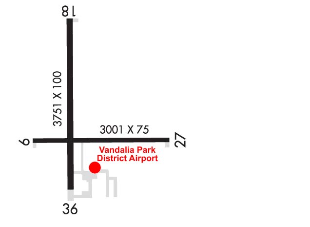
| Lat: N 3859.5 Long: W 08910.0 Elev: 537 Var: +01 Longest Runway: 3751 | ||
| AWOS: 122.8 CTAF: 122.8 | ||
| |||||||||||||||||||||||||||||||||||||||||||||||||||||||||||||
| |||||||||||||||||||||||||||||||||||||||||||||||||||||||||||||
| |||||||||||||||||||||||||||||||||||||||||||||||||||||||||||||
| Rwy | Rwy | |||||||
| 3001x75 | 3001' | 3001x75 | 3001' | |||||
| 3751x100 | 3751' | 3751x100 | 3751' | |||||
| Runway ID | Single Wheel | Double Wheel | Double Tandem Wheel | Dual Double Wheel |
| 09/27 | 19,000 | N/A | N/A | N/A |
| 18/36 | 21,000 | N/A | N/A | N/A |
| These numbers are Advisory and are not limits. The Airport Manager should have more accurate Weight Limits | ||||
 Airport Diagram might not be current. | |
| Facility Name: | VANDALIA MUNI |
| City Name: | VANDALIA |
| County: | FAYETTE |
| State abbrev: | IL |
| State Name: | ILLINOIS |
| Ownership: | PUBLICLY OWNED |
| Use: | OPEN TO THE PUBLIC |
| Owner's Name: | VANDALIA PARK DISTRICT |
| Address: | 900 NORTH LOCUST |
| VANDALIA, IL 62471 | |
| Owner's Phone: | 618-283-4973 |
| Manager's Name: | CHAD FELDPOUCH |
| Address: | 1754 N. 400 ST |
| VANDALIA, IL 62471 | |
| Phone: | 618-267-8035 |
| FAA Region: | GREAT LAKES |
| FAA Field Office: | CHI |
| Date | Sunrise | Sunset |
|---|---|---|
| 09/24/21 Friday | 6:46 | 18:51 |
| 09/25/21 Saturday | 6:47 | 18:49 |
| 09/26/21 Sunday | 6:48 | 18:48 |
| 09/27/21 Monday | 6:49 | 18:46 |
| 09/28/21 Tuesday | 6:50 | 18:44 |
| 09/29/21 Wednesday | 6:51 | 18:43 |
| 09/30/21 Thursday | 6:51 | 18:41 |
| 10/01/21 Friday | 6:52 | 18:40 |
| 10/02/21 Saturday | 6:53 | 18:38 |
| 10/03/21 Sunday | 6:54 | 18:37 |
| 10/04/21 Monday | 6:55 | 18:35 |
| 10/05/21 Tuesday | 6:56 | 18:33 |
| 10/06/21 Wednesday | 6:57 | 18:32 |
| 10/07/21 Thursday | 6:58 | 18:30 |
| Airport Attendance Schedule | IRREGULAR |
| Airport Status | OPERATIONAL (This Status can change at any time - please check NOTAMS) |
| Airport Lighting Schedule | ACTVT REIL RWY 18, 27 & 36; PAPI RWY 18; MIRL RWY 09/27 - CTAF. MIRL RWY 18/36 PRESET TO LOW INTST, TO INCR INTST - CTAF. |
| Airport Storage Available | Tie Downs, Hanger |
| Extra Services Available | Crop Dusting, Flight Instruction |
| Wind Indicator | YES - (lighted) |
| Control Tower | NO |
| CTAF Frequency | 122.800 |
| Unicom Frequency | 122.800 |
| Rotating Beacon Color | CLEAR-GREEN (Light Land Airport) |
| Segmented Circle | YES |
| Landing Fee | NO |
| Airport Inspected | STATE - performed by STATE AERONAUTICAL PERSONNEL |
| Inspection Date | 04/15/2020 |
| Type of Fuel Available | Grade 100LL, JET A (freeze point -40C); -10FUEL IS SELF-SERVE WITH CREDIT CARD. |
| Airframe Repair Service | MAJOR |
| Power Plant Repair Service | MAJOR |
| Latitude | N3859.5 |
| Longitude | W08910.0 (ESTIMATED) |
| Arpt Elevation | 537ft (SURVEYED) |
| Magnetic Variation | 01W |
| 3 miles NW | of VANDALIA |
| Traffic Pattern Altitude | |
| Sectional Chart | ST LOUIS |
| Operations (Reported) | Yearly | Avg. Daily |
|---|---|---|
| General Aviation Transient | 1000 | 3 |
| General Aviation Local | 7950 | 22 |
| Air Taxi | 50 | 0 |
| Commerical | 0 | 0 |
| Commuter | 0 | 0 |
| Military | 0 | 0 |
| Aircraft based on Field | |
|---|---|
| General Aviation Singles | 9 |
| General Aviation Multi | 1 |
| Jet Aircraft | 0 |
| General Aviation Helicopters | 0 |
| Military Aircraft | 0 |
| Gliders | 0 |
| Ultralights | 0 |
| FSS on field | NO |
| FSS tie-in | SAINT LOUIS |
| FSS Phone | 1-800-WX-BRIEF |
| Who issues Notams | STL |
| Notam D service at airport | YES |
| ARTCC Name | KANSAS CITY |
| Airport Certification | |
| Aircraft Rescue & Firefighting Index | None |
| Airport of Entry | No |
| Custom Landing Rights | No |
| Joint Civil/Military | No |
| Military Landing rights | YES |
| NATIONAL PLAN OF INTEGRATED AIRPORT SYSTEMS (NPIAS) |
| GRANT AGREEMENTS UNDER FAAP/ADAP/AIP |
| ASSURANCES PURSUANT TO TITLE VI, CIVIL RIGHTS ACT OF 1964 |
| FOR WX ADVY, 3 CLICKS CTAF. PHONE (618)283-9595. |
| FOR CD CTC KANSAS CITY ARTCC AT 913-254-8508. |
| RWY 27 8 FT CROPS 200 FT FM RWY END PENETRATING PART 77 SFC. |
Airport Communications & Frequencies:
| |||||||||
| Runway: 09 | Runway: 27 | ||
| Mag heading: | 91° | Mag heading: | 271° |
| Rwy Slope: | .18% Up | Rwy Slope: | -.18% Down |
| Approach: | Approach: | ||
| Pattern: | Left Traffic | Pattern: | Left Traffic |
| Markings: | BASIC | Markings: | BASIC |
| Marking Condition: | FAIR | Marking Condition: | FAIR |
| Arresting Dev: | Arresting Dev: | ||
| Lat & Long: | N3859.4 W08910.2 | Lat. & Long.: | N3859.4 W08909.6 |
| Elev: | 531.6 ft. MSL | Elev: | 537.1 ft. MSL |
| TCH: | TCH: | ||
| Visual Glide Path: | Visual Glide Path: | ||
| Displaced Threshold: | No | Displaced Threshold: | No |
| Touchdown Zone: | YES | Touchdown Zone: | YES |
| Touchdown Elev.: | 537.2 feet | Touchdown Elev.: | 537.2 feet |
| Visual Glide Slope: | Visual Glide Slope: | ||
| RVR Equipment: | RVR Equipment: | ||
| RVV Equipment: | NO | RVV Equipment: | NO |
| Approach Lights: | Approach Lights: | ||
| REIL: | NO | REIL: | YES |
| Centerline Lights: | NO | Centerline Lights: | NO |
| Touchdown lights: | NO | Touchdown lights: | NO |
| Runway Category: | Runway with a Visual Approach | Runway Category: | Runway with a Visual Approach |
| Declared Distances: | Declared Distances: |
| Runway: 18 | Runway: 36 | ||
| Mag heading: | 181° | Mag heading: | 1° |
| Rwy Slope: | .08% Up | Rwy Slope: | -.08% Down |
| Approach: | Approach: | ||
| Pattern: | Left Traffic | Pattern: | Left Traffic |
| Markings: | NONPRECISION INSTRUMENT | Markings: | NONPRECISION INSTRUMENT |
| Marking Condition: | GOOD | Marking Condition: | GOOD |
| Arresting Dev: | Arresting Dev: | ||
| Lat & Long: | N3859.9 W08910.0 | Lat. & Long.: | N3859.2 W08910.0 |
| Elev: | 530.1 ft. MSL | Elev: | 533.0 ft. MSL |
| TCH: | 20 ft. AGL | TCH: | |
| Visual Glide Path: | 3.00 degrees | Visual Glide Path: | |
| Displaced Threshold: | No | Displaced Threshold: | No |
| Touchdown Zone: | YES | Touchdown Zone: | YES |
| Touchdown Elev.: | 533.7 feet | Touchdown Elev.: | 533.7 feet |
| Visual Glide Slope: | 4-Light PAPI on LEFT side of Runway | Visual Glide Slope: | |
| RVR Equipment: | RVR Equipment: | ||
| RVV Equipment: | NO | RVV Equipment: | NO |
| Approach Lights: | Approach Lights: | ||
| REIL: | YES | REIL: | YES |
| Centerline Lights: | NO | Centerline Lights: | NO |
| Touchdown lights: | NO | Touchdown lights: | NO |
| Runway Category: | Runway with a Non-precision Approach | Runway Category: | Runway with a Non-precision Approach |
| Declared Distances: | Declared Distances: | ||
| Obstructions: | ROAD | Obstructions: | ROAD |
| Marked: | NOT Marked/Lighted | Marked: | NOT Marked/Lighted |
| Clearance slope: | 20:1 | Clearance slope: | 23:1; APCH SLOPE 23:1 TO RELOCATED THR USING PART 77 SFC. |
| Obstruction height: | 18 feet AGL | Obstruction height: | 14 feet AGL |
| Dist. from runway: | 575 feet | Dist. from runway: | 522 feet |
| Centerline offset: | 284 left of centerline | Centerline offset: | 278 feet right of centerline |
| Comments: | Comments: |
Thanks for using FltPlan.com
all rights reserved © 1999-2021 by Flight Plan LLC