
| VISALIA MUNI VISALIA CA |
| |
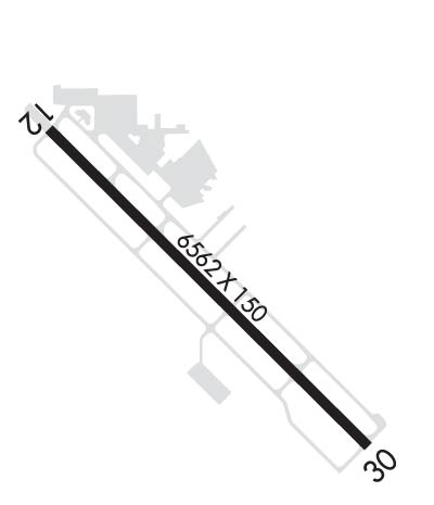
| Lat: N 3619.1 Long: W 11923.6 Elev: 295 Var: -14 Longest Runway: 6562 | ||
| Clr Del: 118.5 AWOS: 119.92 CTAF: 123.05 | ||
| ||||||||||||||||||||||||||||||||||||||||||||
| ||||||||||||||||||||||||||||||||||||||||||||
| ||||||||||||||||||||||||||||||||||||||||||||
| Rwy | Rwy | |||||||
| 6562x150 | 5645' | 6562x150 | 6562' | 108.50 - 300° | ||||
| Runway ID | Single Wheel | Double Wheel | Double Tandem Wheel | Dual Double Wheel |
| 12/30 | 60,000 | 100,000 | 160,000 | N/A |
| H1 | 18,000 | 45,000 | 90,000 | N/A |
| These numbers are Advisory and are not limits. The Airport Manager should have more accurate Weight Limits | ||||
 Airport Diagram might not be current. | |
| Facility Name: | VISALIA MUNI |
| City Name: | VISALIA |
| County: | TULARE |
| State abbrev: | CA |
| State Name: | CALIFORNIA |
| Ownership: | PUBLICLY OWNED |
| Use: | OPEN TO THE PUBLIC |
| Owner's Name: | CITY OF VISALIA |
| Address: | CITY HALL, 707 WEST ACEQUIA |
| VISALIA, CA 93291 | |
| Owner's Phone: | 559-713-4201 |
| Manager's Name: | KATHERINE BALES |
| Address: | 9501 ARPT DRIVE |
| VISALIA, CA 93277 | |
| Phone: | (559) 713-4282 |
| FAA Region: | WESTERN-PACIFIC |
| FAA Field Office: | SFO |
| Date | Sunrise | Sunset |
|---|---|---|
| 09/24/21 Friday | 6:47 | 18:52 |
| 09/25/21 Saturday | 6:48 | 18:50 |
| 09/26/21 Sunday | 6:49 | 18:49 |
| 09/27/21 Monday | 6:49 | 18:47 |
| 09/28/21 Tuesday | 6:50 | 18:46 |
| 09/29/21 Wednesday | 6:51 | 18:44 |
| 09/30/21 Thursday | 6:52 | 18:43 |
| 10/01/21 Friday | 6:53 | 18:41 |
| 10/02/21 Saturday | 6:53 | 18:40 |
| 10/03/21 Sunday | 6:54 | 18:38 |
| 10/04/21 Monday | 6:55 | 18:37 |
| 10/05/21 Tuesday | 6:56 | 18:36 |
| 10/06/21 Wednesday | 6:57 | 18:34 |
| 10/07/21 Thursday | 6:58 | 18:33 |
| Airport Attendance Schedule | MON-FRI 0800-1700, SAT-SUN 0900-1600 |
| Airport Status | OPERATIONAL (This Status can change at any time - please check NOTAMS) |
| Airport Lighting Schedule | ACTVT MALSR RWY 30; REIL RWY 12; PAPI RWY 12 & 30; HIRL RWY 12/30 - CTAF. |
| Airport Storage Available | Tie Downs |
| Extra Services Available | Avionics, Charter, Flight Instruction, Aircraft Rental |
| Wind Indicator | YES - (lighted) |
| Control Tower | NO |
| CTAF Frequency | 123.050 |
| Unicom Frequency | 123.050 |
| Rotating Beacon Color | CLEAR-GREEN (Light Land Airport) |
| Segmented Circle | YES |
| Landing Fee | NO; RON TIEDOWN FEE. |
| Airport Inspected | FEDERAL - performed by STATE AERONAUTICAL PERSONNEL |
| Inspection Date | 03/12/2020 |
| Type of Fuel Available | Grade 100LL, JET A (freeze point -40C); -A SELF-SERVICE FUEL JET A AVBL 24HRS.; -10SELF-SERVICE FUEL 100LL AVBL 24 HRS. |
| Airframe Repair Service | MAJOR |
| Power Plant Repair Service | MAJOR |
| Latitude | N3619.1 |
| Longitude | W11923.6 (ESTIMATED) |
| Arpt Elevation | 294ft (SURVEYED) |
| Magnetic Variation | 14E |
| 4 miles W | of VISALIA |
| Traffic Pattern Altitude | NO DOWNWIND TURNS WHEN DEPARTING RWY 12 UNTIL RCHG TFC PAT ALT. |
| Sectional Chart | SAN FRANCISCO |
| Operations (Reported) | Yearly | Avg. Daily |
|---|---|---|
| General Aviation Transient | 25000 | 68 |
| General Aviation Local | 6000 | 16 |
| Air Taxi | 11000 | 30 |
| Commerical | 2200 | 6 |
| Commuter | 0 | 0 |
| Military | 500 | 1 |
| Aircraft based on Field | |
|---|---|
| General Aviation Singles | 64 |
| General Aviation Multi | 13 |
| Jet Aircraft | 1 |
| General Aviation Helicopters | 0 |
| Military Aircraft | 0 |
| Gliders | 1 |
| Ultralights | 0 |
| FSS on field | NO |
| FSS tie-in | RANCHO MURIETA |
| FSS Phone | 1-800-WX-BRIEF |
| Who issues Notams | VIS |
| Notam D service at airport | YES |
| ARTCC Name | OAKLAND |
| Airport Certification | |
| Aircraft Rescue & Firefighting Index | None |
| Airport of Entry | No |
| Custom Landing Rights | No |
| Joint Civil/Military | No |
| Military Landing rights | YES |
| NATIONAL PLAN OF INTEGRATED AIRPORT SYSTEMS (NPIAS) |
| GRANT AGREEMENTS UNDER FAAP/ADAP/AIP |
| SURPLUS PROPERTY AGREEMENT UNDER REGULATION 16-WAA |
| ASSURANCES PURSUANT TO TITLE VI, CIVIL RIGHTS ACT OF 1964 |
| RY 30 DESIGNATED CALM WIND RY. |
Airport Communications & Frequencies:
|
| Runway: 12 | Runway: 30 | ||
| Mag heading: | 121° | Mag heading: | 301° |
| Rwy Slope: | .05% Up | Rwy Slope: | -.05% Down |
| Approach: | Approach: | ILS | |
| Pattern: | Left Traffic | Pattern: | Left Traffic |
| Markings: | NONPRECISION INSTRUMENT | Markings: | PRECISION INSTRUMENT |
| Marking Condition: | GOOD | Marking Condition: | GOOD |
| Arresting Dev: | Arresting Dev: | ||
| Lat & Long: | N3619.5 W11924.0 | Lat. & Long.: | N3618.7 W11923.1 |
| Elev: | 291.2 ft. MSL | Elev: | 294.4 ft. MSL |
| TCH: | 40 ft. AGL | TCH: | 53 ft. AGL |
| Visual Glide Path: | 3.00 degrees | Visual Glide Path: | 3.00 degrees |
| Displaced Threshold: | 917 feet | Displaced Threshold: | No |
| Touchdown Zone: | YES | Touchdown Zone: | YES |
| Touchdown Elev.: | 293.0 feet | Touchdown Elev.: | 294.5 feet |
| Visual Glide Slope: | 4-Light PAPI on LEFT side of Runway | Visual Glide Slope: | 4-Light PAPI on LEFT side of Runway |
| RVR Equipment: | RVR Equipment: | ||
| RVV Equipment: | NO | RVV Equipment: | NO |
| Approach Lights: | Approach Lights: | MALSR - 1,400 foot medium intensity approach lighting system with runway alignment indicator lights | |
| REIL: | YES | REIL: | NO |
| Centerline Lights: | NO | Centerline Lights: | NO |
| Touchdown lights: | NO | Touchdown lights: | NO |
| Runway Category: | D | Runway Category: | Precision Instrument Runway |
| Declared Distances: | TORA:6560' TODA:7560' ASDA:6560' LDA:5635' | Declared Distances: | TORA:5635' TODA:6635' ASDA:5635' LDA:5635' |
| Obstructions: | FENCE | Obstructions: | TREE |
| Marked: | NOT Marked/Lighted | Marked: | NOT Marked/Lighted |
| Clearance slope: | APCH RATIO 20:1 TO DSPLCD THLD. | Clearance slope: | 48:1 |
| Obstruction height: | 4 feet AGL | Obstruction height: | 61 feet AGL |
| Dist. from runway: | 200 feet | Dist. from runway: | 3175 feet |
| Centerline offset: | 250 right of centerline | Centerline offset: | 725 feet right of centerline |
| Comments: | Comments: |
Thanks for using FltPlan.com
all rights reserved © 1999-2021 by Flight Plan LLC
