| ROLLA NATIONAL ROLLA/VICHY MO |
| |
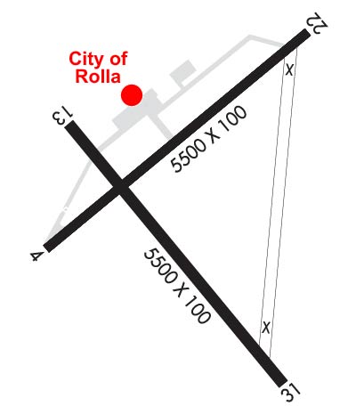
| Lat: N 3807.6 Long: W 09146.2 Elev: 1148 Var: -02 Longest Runway: 5500 | ||
| AWOS: 119.02 CTAF: 123.0 | ||
| ||||||||||||||||||||||||||||||||||||||||||||||||||||||||||||||||||||
| ||||||||||||||||||||||||||||||||||||||||||||||||||||||||||||||||||||
| ||||||||||||||||||||||||||||||||||||||||||||||||||||||||||||||||||||
| Rwy | Rwy | |||||||
| 5500x100 | 5287' | 5500x100 | 5500' | |||||
| 5500x100 | 5500' | 5500x100 | 5500' | |||||
| Runway ID | Single Wheel | Double Wheel | Double Tandem Wheel | Dual Double Wheel |
| 04/22 | 75,000 | 85,000 | 130,000 | N/A |
| 13/31 | 48,000 | 62,000 | 92,000 | N/A |
| These numbers are Advisory and are not limits. The Airport Manager should have more accurate Weight Limits | ||||
 Airport Diagram might not be current. | |
| Facility Name: | ROLLA NTL |
| City Name: | ROLLA/VICHY |
| County: | MARIES |
| State abbrev: | MO |
| State Name: | MISSOURI |
| Ownership: | PUBLICLY OWNED |
| Use: | OPEN TO THE PUBLIC |
| Owner's Name: | CITY OF ROLLA |
| Address: | 901 N. ELM ST., PO BOX 979 |
| ROLLA, MO 65401 | |
| Owner's Phone: | 573-426-6948 |
| Manager's Name: | DARRIN BACON |
| Address: | 631 AIRPORT DRIVE |
| VICHY, MO 65580 | |
| Phone: | 573-299-4498 |
| FAA Region: | CENTRAL |
| FAA Field Office: | NONE |
| Date | Sunrise | Sunset |
|---|---|---|
| 09/24/21 Friday | 6:56 | 19:01 |
| 09/25/21 Saturday | 6:57 | 19:00 |
| 09/26/21 Sunday | 6:58 | 18:58 |
| 09/27/21 Monday | 6:59 | 18:57 |
| 09/28/21 Tuesday | 7:00 | 18:55 |
| 09/29/21 Wednesday | 7:01 | 18:53 |
| 09/30/21 Thursday | 7:02 | 18:52 |
| 10/01/21 Friday | 7:03 | 18:50 |
| 10/02/21 Saturday | 7:03 | 18:49 |
| 10/03/21 Sunday | 7:04 | 18:47 |
| 10/04/21 Monday | 7:05 | 18:46 |
| 10/05/21 Tuesday | 7:06 | 18:44 |
| 10/06/21 Wednesday | 7:07 | 18:43 |
| 10/07/21 Thursday | 7:08 | 18:41 |
| Airport Attendance Schedule | MON-FRI 0600-1700, SAT-SUN 0700-1700 |
| Airport Status | OPERATIONAL (This Status can change at any time - please check NOTAMS) |
| Airport Lighting Schedule | ACTVT PAPI RWY 04; VASI RWY 22; MIRL RWY 04/22 AND RWY 13/31 - CTAF. |
| Airport Storage Available | Tie Downs |
| Extra Services Available | Flight Instruction, Parachute Jumping |
| Wind Indicator | YES - (lighted) |
| Control Tower | NO |
| CTAF Frequency | 123.000 |
| Unicom Frequency | 123.000 |
| Rotating Beacon Color | CLEAR-GREEN (Light Land Airport) |
| Segmented Circle | NO |
| Landing Fee | NO |
| Airport Inspected | STATE - performed by STATE AERONAUTICAL PERSONNEL |
| Inspection Date | 09/28/2020 |
| Type of Fuel Available | Grade 100LL, JET A (freeze point -40C) |
| Airframe Repair Service | MINOR; AIRFRAME & PWR PLANT RPRS EMERG ONLY. |
| Power Plant Repair Service | MINOR |
| Latitude | N3807.6 |
| Longitude | W09146.2 (ESTIMATED) |
| Arpt Elevation | 1148ft (SURVEYED) |
| Magnetic Variation | 02E |
| 11 miles N | of ROLLA/VICHY |
| Traffic Pattern Altitude | |
| Sectional Chart | KANSAS CITY |
| Operations (Reported) | Yearly | Avg. Daily |
|---|---|---|
| General Aviation Transient | 15000 | 41 |
| General Aviation Local | 16000 | 44 |
| Air Taxi | 2000 | 5 |
| Commerical | 0 | 0 |
| Commuter | 0 | 0 |
| Military | 2500 | 7 |
| Aircraft based on Field | |
|---|---|
| General Aviation Singles | 56 |
| General Aviation Multi | 9 |
| Jet Aircraft | 2 |
| General Aviation Helicopters | 0 |
| Military Aircraft | 0 |
| Gliders | 1 |
| Ultralights | 0 |
| FSS on field | NO |
| FSS tie-in | COLUMBIA |
| FSS Phone | 1-800-WX-BRIEF |
| Who issues Notams | VIH |
| Notam D service at airport | YES |
| ARTCC Name | KANSAS CITY |
| Airport Certification | |
| Aircraft Rescue & Firefighting Index | None |
| Airport of Entry | No |
| Custom Landing Rights | No |
| Joint Civil/Military | No |
| Military Landing rights | YES |
| NATIONAL PLAN OF INTEGRATED AIRPORT SYSTEMS (NPIAS) |
| GRANT AGREEMENTS UNDER FAAP/ADAP/AIP |
| CONVEYANCE UNDER SCETION 16, FEDERAL AIRPORT ACT OF 1946 OR SECTION 23, AIRPORT AND AIRWAY DEVELOPMENT ACT OF 1970 |
| OBLIGATIONS ASSUMED BY TRANSFER |
| ASSURANCES PURSUANT TO TITLE VI, CIVIL RIGHTS ACT OF 1964 |
| 144 FT WATER TOWER LCTD 2000 FT NNE OF RWY 13 THLD. |
| RADIO CONTROLLED MODEL AIRPLANES INVOF ARPT. |
| HELI PARKING ON SE CORNER OF APRON. |
| WILDLIFE ON & INVOF ARPT. |
| 270 FT ANTENNA TOWER 1.5 MILES SE OF RWY 31 THLD |
| CLSD RWY UNUSBL AS TWY. |
| FOR CD IF UNA TO CTC ON FSS FREQ, CTC KANSAS CITY ARTCC AT 913-254-8508. |
Airport Communications & Frequencies:
| |||||||||
| Runway: 04 | Runway: 22 | ||
| Mag heading: | 45° | Mag heading: | 225° |
| Rwy Slope: | -.51% Down | Rwy Slope: | .51% Up |
| Approach: | Approach: | ||
| Pattern: | Left Traffic | Pattern: | Left Traffic |
| Markings: | NONPRECISION INSTRUMENT | Markings: | NONPRECISION INSTRUMENT |
| Marking Condition: | GOOD | Marking Condition: | FAIR |
| Arresting Dev: | Arresting Dev: | ||
| Lat & Long: | N3807.5 W09146.6 | Lat. & Long.: | N3808.1 W09145.8 |
| Elev: | 1137.0 ft. MSL | Elev: | 1109.1 ft. MSL |
| TCH: | 40 ft. AGL | TCH: | 52 ft. AGL |
| Visual Glide Path: | 3.00 degrees | Visual Glide Path: | 3.00 degrees |
| Displaced Threshold: | 213 feet | Displaced Threshold: | No |
| Touchdown Zone: | YES | Touchdown Zone: | YES |
| Touchdown Elev.: | 1137.0 feet | Touchdown Elev.: | 1117.3 feet |
| Visual Glide Slope: | 4-Light PAPI on LEFT side of Runway | Visual Glide Slope: | 4-BOX VASI ON LEFT SIDE OF RUNWAY |
| RVR Equipment: | RVR Equipment: | ||
| RVV Equipment: | NO | RVV Equipment: | NO |
| Approach Lights: | Approach Lights: | ||
| REIL: | NO | REIL: | NO |
| Centerline Lights: | NO | Centerline Lights: | NO |
| Touchdown lights: | NO | Touchdown lights: | NO |
| Runway Category: | Runway with a Non-precision Approach having visibility minimums greater than 3/4 mile | Runway Category: | Runway with a Non-precision Approach having visibility minimums greater than 3/4 mile |
| Declared Distances: | Declared Distances: | ||
| Obstructions: | ROAD | Obstructions: | TREE |
| Marked: | NOT Marked/Lighted | Marked: | NOT Marked/Lighted |
| Clearance slope: | 11:1; APCH RATIO TO DSPLCD THLD 29:1; DSPLCD THLD 1 FT LOWER THAN RY END. | Clearance slope: | 13:1 |
| Obstruction height: | 20 feet AGL | Obstruction height: | 22 feet AGL |
| Dist. from runway: | 435 feet | Dist. from runway: | 500 feet |
| Centerline offset: | 270 right of centerline | Centerline offset: | 69 feet right of centerline |
| Comments: | Comments: |
| Runway: 13 | Runway: 31 | ||
| Mag heading: | 135° | Mag heading: | 315° |
| Rwy Slope: | .21% Up | Rwy Slope: | -.21% Down |
| Approach: | Approach: | ||
| Pattern: | Left Traffic | Pattern: | Left Traffic |
| Markings: | BASIC | Markings: | BASIC |
| Marking Condition: | FAIR | Marking Condition: | FAIR |
| Arresting Dev: | Arresting Dev: | ||
| Lat & Long: | N3807.8 W09146.6 | Lat. & Long.: | N3807.2 W09145.8 |
| Elev: | 1136.7 ft. MSL | Elev: | 1148.0 ft. MSL |
| TCH: | TCH: | ||
| Visual Glide Path: | Visual Glide Path: | ||
| Displaced Threshold: | No | Displaced Threshold: | No |
| Touchdown Zone: | YES | Touchdown Zone: | YES |
| Touchdown Elev.: | 1136.7 feet | Touchdown Elev.: | 1148.0 feet |
| Visual Glide Slope: | Visual Glide Slope: | ||
| RVR Equipment: | RVR Equipment: | ||
| RVV Equipment: | NO | RVV Equipment: | NO |
| Approach Lights: | Approach Lights: | ||
| REIL: | NO | REIL: | NO |
| Centerline Lights: | NO | Centerline Lights: | NO |
| Touchdown lights: | NO | Touchdown lights: | NO |
| Runway Category: | Runway with a Visual Approach | Runway Category: | Runway with a Visual Approach |
| Declared Distances: | Declared Distances: |
Thanks for using FltPlan.com
all rights reserved © 1999-2021 by Flight Plan LLC