| DARKE COUNTY VERSAILLES OH |
| |
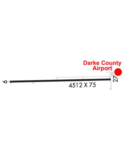
| Lat: N 4012.3 Long: W 08431.9 Elev: 1007 Var: +04 Longest Runway: 4802 | ||
| AWOS: 125.9 CTAF: 122.8 | ||
| |||||||||||||||||||||||||||||||
| |||||||||||||||||||||||||||||||
| |||||||||||||||||||||||||||||||
| Rwy | Rwy | |||||||
| 4802x75 | 4802' | 4802x75 | 4802' | |||||
| Runway ID | Single Wheel | Double Wheel | Double Tandem Wheel | Dual Double Wheel |
| 09/27 | 12,500 | N/A | N/A | N/A |
| These numbers are Advisory and are not limits. The Airport Manager should have more accurate Weight Limits | ||||
 Airport Diagram might not be current. | |
| Facility Name: | DARKE COUNTY |
| City Name: | VERSAILLES |
| County: | DARKE |
| State abbrev: | OH |
| State Name: | OHIO |
| Ownership: | PUBLICLY OWNED |
| Use: | OPEN TO THE PUBLIC |
| Owner's Name: | DARKE CO COMMISSIONERS |
| Address: | DARKE CO COURTHOUSE |
| GREENVILLE, OH 45331-1993 | |
| Owner's Phone: | 937-547-7370 |
| Manager's Name: | SCOTT NAAS; SNAAS@CO.DARKE.OH.US. |
| Address: | 9724 STATE ROUTE 121 |
| VERSAILLES, OH 45380-9513 | |
| Phone: | 937-467-9360 |
| FAA Region: | GREAT LAKES |
| FAA Field Office: | DET |
| Date | Sunrise | Sunset |
|---|---|---|
| 06/08/26 Monday | 6:09 | 21:06 |
| 06/09/26 Tuesday | 6:08 | 21:06 |
| 06/10/26 Wednesday | 6:08 | 21:07 |
| 06/11/26 Thursday | 6:08 | 21:07 |
| 06/12/26 Friday | 6:08 | 21:08 |
| 06/13/26 Saturday | 6:08 | 21:08 |
| 06/14/26 Sunday | 6:08 | 21:09 |
| 06/15/26 Monday | 6:08 | 21:09 |
| 06/16/26 Tuesday | 6:08 | 21:10 |
| 06/17/26 Wednesday | 6:08 | 21:10 |
| 06/18/26 Thursday | 6:08 | 21:10 |
| 06/19/26 Friday | 6:08 | 21:11 |
| 06/20/26 Saturday | 6:08 | 21:11 |
| 06/21/26 Sunday | 6:09 | 21:11 |
| Airport Attendance Schedule | MON-FRI 0800-1630 |
| Airport Status | OPERATIONAL (This Status can change at any time - please check NOTAMS) |
| Airport Lighting Schedule | ACTVT REIL RWY 09 & 27; MIRL RWY 09/27 - CTAF. PAPI RWY 09 & 27 OPR CONSLY. |
| Airport Storage Available | Tie Downs, Hanger |
| Extra Services Available | Air Ambulance |
| Wind Indicator | YES - (lighted) |
| Control Tower | NO |
| CTAF Frequency | 122.800 |
| Unicom Frequency | 122.800 |
| Rotating Beacon Color | WG |
| Segmented Circle | NO |
| Landing Fee | NO |
| Airport Inspected | STATE - performed by STATE AERONAUTICAL PERSONNEL |
| Inspection Date | 09/16/2024 |
| Type of Fuel Available | Grade 100LL, JET A; -10FUEL LCTD AT EAST RAMP AVBL H24 VIA CREDIT CARD. |
| Airframe Repair Service | NONE |
| Power Plant Repair Service | NONE |
| Latitude | N4012.3 |
| Longitude | W08431.9 (ESTIMATED) |
| Arpt Elevation | 1007ft (SURVEYED) |
| Magnetic Variation | 04W |
| 2 miles SW | of VERSAILLES |
| Traffic Pattern Altitude | |
| Sectional Chart | DETROIT |
| Operations (Reported) | Yearly | Avg. Daily |
|---|---|---|
| General Aviation Transient | 0 | 0 |
| General Aviation Local | 0 | 0 |
| Air Taxi | 0 | 0 |
| Commerical | 0 | 0 |
| Commuter | 0 | 0 |
| Military | 0 | 0 |
| Aircraft based on Field | |
|---|---|
| General Aviation Singles | 0 |
| General Aviation Multi | 0 |
| Jet Aircraft | 0 |
| General Aviation Helicopters | 0 |
| Military Aircraft | 0 |
| Gliders | 0 |
| Ultralights | 0 |
| FSS on field | NO |
| FSS tie-in | DAYTON |
| FSS Phone | 1-800-WX-BRIEF |
| Who issues Notams | VES |
| Notam D service at airport | YES |
| ARTCC Name | INDIANAPOLIS |
| Airport Certification | |
| Aircraft Rescue & Firefighting Index | None |
| Airport of Entry | No |
| Custom Landing Rights | No |
| Joint Civil/Military | No |
| Military Landing rights | No |
| NATIONAL PLAN OF INTEGRATED AIRPORT SYSTEMS (NPIAS) |
| OCNL DEER, BIRDS, & OTR WILDLIFE ON & INVOF ARPT. |
| FOR CD CTC COLUMBUS APCH AT 614-338-8537. |
Airport Communications & Frequencies:
| ||||||||||||||
| Runway: 09 | Runway: 27 | ||
| Mag heading: | 93° | Mag heading: | 273° |
| Rwy Slope: | -.02% Down | Rwy Slope: | .02% Up |
| Approach: | Approach: | ||
| Pattern: | Left Traffic | Pattern: | Left Traffic |
| Markings: | NONPRECISION INSTRUMENT | Markings: | NONPRECISION INSTRUMENT |
| Marking Condition: | GOOD | Marking Condition: | GOOD |
| Arresting Dev: | Arresting Dev: | ||
| Lat & Long: | N4012.3 W08432.5 | Lat. & Long.: | N4012.3 W08431.4 |
| Elev: | 1004.8 ft. MSL | Elev: | 1004.0 ft. MSL |
| TCH: | 38 ft. AGL | TCH: | 45 ft. AGL |
| Visual Glide Path: | 3.00 degrees | Visual Glide Path: | 3.00 degrees |
| Displaced Threshold: | No | Displaced Threshold: | No |
| Touchdown Zone: | YES | Touchdown Zone: | YES |
| Touchdown Elev.: | 1007.0 feet | Touchdown Elev.: | 1007.0 feet |
| Visual Glide Slope: | 2-Light PAPI on LEFT side of Runway | Visual Glide Slope: | 2-Light PAPI on LEFT side of Runway |
| RVR Equipment: | RVR Equipment: | ||
| RVV Equipment: | NO | RVV Equipment: | NO |
| Approach Lights: | Approach Lights: | ||
| REIL: | YES | REIL: | YES |
| Centerline Lights: | NO | Centerline Lights: | NO |
| Touchdown lights: | NO | Touchdown lights: | NO |
| Runway Category: | Runway with a Non-precision Approach | Runway Category: | Runway with a Non-precision Approach |
| Declared Distances: | Declared Distances: |
Thanks for using FltPlan.com
all rights reserved © 1999-2026 by Flight Plan LLC