
| JESSE VIERTEL MEMORIAL BOONVILLE MO |
| |
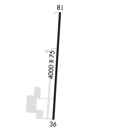
| Lat: N 3856.8 Long: W 09241.0 Elev: 715 Var: -02 Longest Runway: 4000 | ||
| AWOS: 119.62 CTAF: 122.7 | ||
| ||||||
| ||||||
|
| Rwy | Rwy | |||||||
| 4000x75 | 4000' | 4000x75 | 4000' | |||||
| Runway ID | Single Wheel | Double Wheel | Double Tandem Wheel | Dual Double Wheel |
| 18/36 | 12,500 | N/A | N/A | N/A |
| These numbers are Advisory and are not limits. The Airport Manager should have more accurate Weight Limits | ||||
 Airport Diagram might not be current. | |
| Facility Name: | JESSE VIERTEL MEML |
| City Name: | BOONVILLE |
| County: | COOPER |
| State abbrev: | MO |
| State Name: | MISSOURI |
| Ownership: | PUBLICLY OWNED |
| Use: | OPEN TO THE PUBLIC |
| Owner's Name: | CITY OF BOONVILLE |
| Address: | 401 MAIN ST |
| BOONVILLE, MO 65233 | |
| Owner's Phone: | 660-882-2332 |
| Manager's Name: | JOHN TAYLOR |
| Address: | 20044 PEARRE RD |
| BOONVILLE, MO 65233 | |
| Phone: | 660-882-7441 |
| FAA Region: | CENTRAL |
| FAA Field Office: | NONE |
| Date | Sunrise | Sunset |
|---|---|---|
| 09/24/21 Friday | 7:00 | 19:05 |
| 09/25/21 Saturday | 7:01 | 19:03 |
| 09/26/21 Sunday | 7:02 | 19:02 |
| 09/27/21 Monday | 7:03 | 19:00 |
| 09/28/21 Tuesday | 7:04 | 18:58 |
| 09/29/21 Wednesday | 7:05 | 18:57 |
| 09/30/21 Thursday | 7:06 | 18:55 |
| 10/01/21 Friday | 7:06 | 18:54 |
| 10/02/21 Saturday | 7:07 | 18:52 |
| 10/03/21 Sunday | 7:08 | 18:51 |
| 10/04/21 Monday | 7:09 | 18:49 |
| 10/05/21 Tuesday | 7:10 | 18:47 |
| 10/06/21 Wednesday | 7:11 | 18:46 |
| 10/07/21 Thursday | 7:12 | 18:44 |
| Airport Attendance Schedule | 7 Days A Week 0800-2000 |
| Airport Status | OPERATIONAL (This Status can change at any time - please check NOTAMS) |
| Airport Lighting Schedule | ACTVT MIRL RY 18/36; PAPI RYS 18 & 36; REIL RYS 18 & 36 - CTAF. |
| Airport Storage Available | Tie Downs |
| Extra Services Available | Crop Dusting, Flight Instruction, Aircraft Rental |
| Wind Indicator | YES - (lighted) |
| Control Tower | NO |
| CTAF Frequency | 122.700 |
| Unicom Frequency | 122.700 |
| Rotating Beacon Color | CLEAR-GREEN (Light Land Airport) |
| Segmented Circle | YES |
| Landing Fee | NO |
| Airport Inspected | STATE - performed by STATE AERONAUTICAL PERSONNEL |
| Inspection Date | 08/26/2020 |
| Type of Fuel Available | Grade 100LL, JET A (freeze point -40C); -10SELF-SVC FUEL AVBL 24 HRS. |
| Airframe Repair Service | MAJOR |
| Power Plant Repair Service | MAJOR |
| Latitude | N3856.8 |
| Longitude | W09241.0 (ESTIMATED) |
| Arpt Elevation | 715ft (SURVEYED) |
| Magnetic Variation | 02E |
| 3 miles SE | of BOONVILLE |
| Traffic Pattern Altitude | 785 |
| Sectional Chart | KANSAS CITY |
| Operations (Reported) | Yearly | Avg. Daily |
|---|---|---|
| General Aviation Transient | 3800 | 10 |
| General Aviation Local | 8000 | 22 |
| Air Taxi | 350 | 1 |
| Commerical | 0 | 0 |
| Commuter | 0 | 0 |
| Military | 300 | 1 |
| Aircraft based on Field | |
|---|---|
| General Aviation Singles | 41 |
| General Aviation Multi | 0 |
| Jet Aircraft | 0 |
| General Aviation Helicopters | 1 |
| Military Aircraft | 0 |
| Gliders | 1 |
| Ultralights | 0 |
| FSS on field | NO |
| FSS tie-in | COLUMBIA |
| FSS Phone | 1-800-WX-BRIEF |
| Who issues Notams | COU |
| Notam D service at airport | YES |
| ARTCC Name | KANSAS CITY |
| Airport Certification | |
| Aircraft Rescue & Firefighting Index | None |
| Airport of Entry | No |
| Custom Landing Rights | No |
| Joint Civil/Military | No |
| Military Landing rights | YES |
| NATIONAL PLAN OF INTEGRATED AIRPORT SYSTEMS (NPIAS) |
| GRANT AGREEMENTS UNDER FAAP/ADAP/AIP |
| ASSURANCES PURSUANT TO TITLE VI, CIVIL RIGHTS ACT OF 1964 |
| THIS AIRPORT HAS BEEN SURVEYED BY THE NATIONAL GEODETIC SURVEY. |
| EXTSV STUDENT PILOT TRNG INVOF ARPT. |
| NOISE ABATEMENT, FOR RY 36 FLY RY CNTRLN TO 1,500 FT BEFORE TURNING ON CRS. |
| RY 18 CALM WIND RY. |
| INTENSIVE AERIAL CROP-DUSTING ACTIVITY APRIL-OCTOBER |
| FOR CD CTC MIZZOU APCH AT 417-868-5620/5619. |
Airport Communications & Frequencies:
|
| Runway: 18 | Runway: 36 | ||
| Mag heading: | 183° | Mag heading: | 3° |
| Rwy Slope: | .08% Up | Rwy Slope: | -.08% Down |
| Approach: | Approach: | ||
| Pattern: | Left Traffic | Pattern: | Left Traffic |
| Markings: | NONPRECISION INSTRUMENT | Markings: | NONPRECISION INSTRUMENT |
| Marking Condition: | GOOD | Marking Condition: | GOOD |
| Arresting Dev: | Arresting Dev: | ||
| Lat & Long: | N3857.1 W09240.9 | Lat. & Long.: | N3856.5 W09241.0 |
| Elev: | 708.7 ft. MSL | Elev: | 711.9 ft. MSL |
| TCH: | 37 ft. AGL | TCH: | 37 ft. AGL |
| Visual Glide Path: | 3.00 degrees | Visual Glide Path: | 3.00 degrees |
| Displaced Threshold: | No | Displaced Threshold: | No |
| Touchdown Zone: | YES | Touchdown Zone: | YES |
| Touchdown Elev.: | 715.0 feet | Touchdown Elev.: | 715.0 feet |
| Visual Glide Slope: | 4-Light PAPI on LEFT side of Runway | Visual Glide Slope: | 4-Light PAPI on LEFT side of Runway |
| RVR Equipment: | RVR Equipment: | ||
| RVV Equipment: | NO | RVV Equipment: | NO |
| Approach Lights: | Approach Lights: | ||
| REIL: | YES | REIL: | YES |
| Centerline Lights: | NO | Centerline Lights: | NO |
| Touchdown lights: | NO | Touchdown lights: | NO |
| Runway Category: | Runway with a Non-precision Approach having visibility minimums greater than 3/4 mile | Runway Category: | Runway with a Non-precision Approach having visibility minimums greater than 3/4 mile |
| Declared Distances: | Declared Distances: | ||
| Obstructions: | Obstructions: | TREE | |
| Marked: | Marked: | NOT Marked/Lighted | |
| Clearance slope: | 34:1 | Clearance slope: | 26:1 |
| Obstruction height: | Obstruction height: | 57 feet AGL | |
| Dist. from runway: | Dist. from runway: | 1700 feet | |
| Centerline offset: | Centerline offset: | 140 feet left of centerline | |
| Comments: | Comments: |
Thanks for using FltPlan.com
all rights reserved © 1999-2021 by Flight Plan LLC
