| VERNAL REGIONAL AP VERNAL UT |
| |
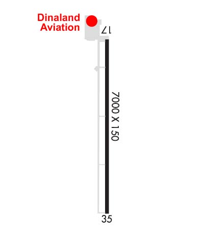
| Lat: N 4026.2 Long: W 10930.7 Elev: 5274 Var: -10 Longest Runway: 7000 | ||
| CTAF: 122.7 | ||
| ||||||||||||||||||||||||||||||||||||||||||||||||||||||||||||||||||||
| ||||||||||||||||||||||||||||||||||||||||||||||||||||||||||||||||||||
| ||||||||||||||||||||||||||||||||||||||||||||||||||||||||||||||||||||
| ||||||||||||||||||||||||||||||||||||||||||||||||||||||||||||||||||||
| Rwy | Rwy | |||||||
| 7000x100 | 7000' | 7000x100 | 7000' | |||||
| Runway ID | Single Wheel | Double Wheel | Double Tandem Wheel | Dual Double Wheel |
| 17/35 | 45,000 | 55,000 | N/A | N/A |
| These numbers are Advisory and are not limits. The Airport Manager should have more accurate Weight Limits | ||||
 Airport Diagram might not be current. | |
| Facility Name: | VERNAL RGNL |
| City Name: | VERNAL |
| County: | UINTAH |
| State abbrev: | UT |
| State Name: | UTAH |
| Ownership: | PUBLICLY OWNED |
| Use: | OPEN TO THE PUBLIC |
| Owner's Name: | UINTAH CO AND VERNAL CITY |
| Address: | 152 E 100 N. |
| VERNAL, UT 84078 | |
| Owner's Phone: | (435) 781-0770 |
| Manager's Name: | KEN CAMPBELL |
| Address: | 730 EAST 800 S. |
| VERNAL, UT 84078 | |
| Phone: | (435) 789-3400 |
| FAA Region: | NORTHWEST MOUNTAIN |
| FAA Field Office: | DEN |
| Date | Sunrise | Sunset |
|---|---|---|
| 06/08/26 Monday | 5:48 | 20:47 |
| 06/09/26 Tuesday | 5:48 | 20:47 |
| 06/10/26 Wednesday | 5:47 | 20:48 |
| 06/11/26 Thursday | 5:47 | 20:48 |
| 06/12/26 Friday | 5:47 | 20:49 |
| 06/13/26 Saturday | 5:47 | 20:49 |
| 06/14/26 Sunday | 5:47 | 20:50 |
| 06/15/26 Monday | 5:47 | 20:50 |
| 06/16/26 Tuesday | 5:47 | 20:50 |
| 06/17/26 Wednesday | 5:47 | 20:51 |
| 06/18/26 Thursday | 5:47 | 20:51 |
| 06/19/26 Friday | 5:47 | 20:51 |
| 06/20/26 Saturday | 5:48 | 20:52 |
| 06/21/26 Sunday | 5:48 | 20:52 |
| Airport Attendance Schedule | 7 Days A Week DAWN-DUSK; AFT HR OPS CTC 435-789-8494 OR 435-261-9000. |
| Airport Status | OPERATIONAL (This Status can change at any time - please check NOTAMS) |
| Airport Lighting Schedule | ACTVT REIL RWY 17 & 35; MIRL RWY 17/35 - CTAF. PAPI RWY 17 & 35 ON CONSLY. |
| Airport Storage Available | Tie Downs, Hanger |
| Extra Services Available | Air Freight, Flight Instruction, Aircraft Rental |
| Wind Indicator | YES - (lighted) |
| Control Tower | NO |
| CTAF Frequency | 122.700 |
| Unicom Frequency | 122.700 |
| Rotating Beacon Color | WG |
| Segmented Circle | YES |
| Landing Fee | NO |
| Airport Inspected | FEDERAL - performed by FAA AIRPORTS FIELD PERSONNEL |
| Inspection Date | 04/14/2026 |
| Type of Fuel Available | Grade 100LL, JET A (freeze point -40C) |
| Airframe Repair Service | MAJOR |
| Power Plant Repair Service | MAJOR |
| Latitude | N4026.2 |
| Longitude | W10930.7 (ESTIMATED) |
| Arpt Elevation | 5274ft (SURVEYED) |
| Magnetic Variation | 10E |
| 1 miles SE | of VERNAL |
| Traffic Pattern Altitude | |
| Sectional Chart | SALT LAKE CITY |
| Operations (Reported) | Yearly | Avg. Daily |
|---|---|---|
| General Aviation Transient | 0 | 0 |
| General Aviation Local | 0 | 0 |
| Air Taxi | 0 | 0 |
| Commerical | 0 | 0 |
| Commuter | 0 | 0 |
| Military | 0 | 0 |
| Aircraft based on Field | |
|---|---|
| General Aviation Singles | 0 |
| General Aviation Multi | 0 |
| Jet Aircraft | 0 |
| General Aviation Helicopters | 0 |
| Military Aircraft | 0 |
| Gliders | 0 |
| Ultralights | 0 |
| FSS on field | NO |
| FSS tie-in | CEDAR CITY |
| FSS Phone | 1-800-WX-BRIEF |
| Who issues Notams | VEL |
| Notam D service at airport | YES |
| ARTCC Name | SALT LAKE CITY |
| Airport Certification | AIRPORT RECEIVING SCHEDULED AIR CARRIER SERVICE FROM CARRIERS CERTIFICATED BY THE CIVIL AERONAUTICS BOARD; 24 HR PPR FOR ACR OPS OVR 30 PAX SEATS - AMGR. |
| Aircraft Rescue & Firefighting Index | AIRPORT HAS A CERTIFICATE UNDER CFR PART 139 |
| Airport of Entry | No |
| Custom Landing Rights | No |
| Joint Civil/Military | No |
| Military Landing rights | YES |
| NATIONAL PLAN OF INTEGRATED AIRPORT SYSTEMS (NPIAS) |
| GRANT AGREEMENTS UNDER FAAP/ADAP/AIP |
| ASSURANCES PURSUANT TO TITLE VI, CIVIL RIGHTS ACT OF 1964 |
| RWY 07/25 DECOMMISSIONED. |
| FOR CD IF UNA TO CTC ON FSS FREQ, CTC SALT LAKE ARTCC AT 801-320-2568. |
| COLD TEMPERATURE AIRPORT. ALTITUDE CORRECTION REQUIRED AT OR BELOW -26C. |
| RWY 17/3 5 PCR VALUE: 230/F/D/X/T |
Airport Communications & Frequencies:
| |||||||||
| Runway: 17 | Runway: 35 | ||
| Mag heading: | 169° | Mag heading: | 349° |
| Rwy Slope: | .09% Up | Rwy Slope: | -.09% Down |
| Approach: | Approach: | ||
| Pattern: | Left Traffic | Pattern: | Left Traffic |
| Markings: | NONPRECISION INSTRUMENT | Markings: | NONPRECISION INSTRUMENT |
| Marking Condition: | GOOD | Marking Condition: | GOOD |
| Arresting Dev: | Arresting Dev: | ||
| Lat & Long: | N4026.7 W10930.7 | Lat. & Long.: | N4025.6 W10930.7 |
| Elev: | 5267.8 ft. MSL | Elev: | 5274.2 ft. MSL |
| TCH: | 48 ft. AGL | TCH: | 48 ft. AGL |
| Visual Glide Path: | 3.00 degrees | Visual Glide Path: | 3.00 degrees |
| Displaced Threshold: | No | Displaced Threshold: | No |
| Touchdown Zone: | YES | Touchdown Zone: | YES |
| Touchdown Elev.: | 5267.9 feet | Touchdown Elev.: | 5274.2 feet |
| Visual Glide Slope: | 4-Light PAPI on LEFT side of Runway | Visual Glide Slope: | 4-Light PAPI on LEFT side of Runway |
| RVR Equipment: | RVR Equipment: | ||
| RVV Equipment: | NO | RVV Equipment: | NO |
| Approach Lights: | Approach Lights: | ||
| REIL: | YES | REIL: | YES |
| Centerline Lights: | NO | Centerline Lights: | NO |
| Touchdown lights: | NO | Touchdown lights: | NO |
| Runway Category: | Runway with a Visual Approach | Runway Category: | Runway with a Non-precision Approach having visibility minimums greater than 3/4 mile |
| Declared Distances: | TORA:7000' | Declared Distances: | TORA:7000' |
| Obstructions: | POLE | Obstructions: | TREES |
| Marked: | NOT Marked/Lighted | Marked: | NOT Marked/Lighted |
| Clearance slope: | 11:1 | Clearance slope: | 20:1 |
| Obstruction height: | 33 feet AGL | Obstruction height: | 44 feet AGL |
| Dist. from runway: | 586 feet | Dist. from runway: | 1094 feet |
| Centerline offset: | 367 left of centerline | Centerline offset: | 203 feet right of centerline |
| Comments: | Comments: |
Thanks for using FltPlan.com
all rights reserved © 1999-2026 by Flight Plan LLC