
| VIDALIA RGNL VIDALIA GA |
| |
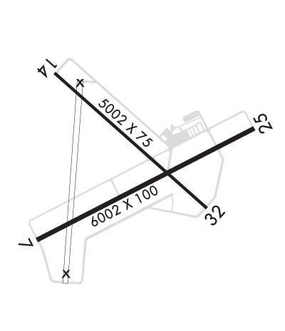
| Lat: N 3211.6 Long: W 08222.3 Elev: 274 Var: +06 Longest Runway: 6002 | ||
| Clr Del: 121.72 GCO AWOS: 119.92 CTAF: 122.8 | ||
| ||||||||||||||||||||||||||||||||||||||||||||
| ||||||||||||||||||||||||||||||||||||||||||||
| ||||||||||||||||||||||||||||||||||||||||||||
| Rwy | Rwy | |||||||
| 6002x100 | 6002' | 6002x100 | 6002' | 110.30 - 248° | ||||
| 5002x75 | 5002' | 5002x75 | 5002' | |||||
| Runway ID | Single Wheel | Double Wheel | Double Tandem Wheel | Dual Double Wheel |
| 07/25 | 30,000 | 48,000 | 85,000 | N/A |
| 14/32 | 30,000 | 48,000 | 85,000 | N/A |
| These numbers are Advisory and are not limits. The Airport Manager should have more accurate Weight Limits | ||||
 Airport Diagram might not be current. | |
| Facility Name: | VIDALIA RGNL |
| City Name: | VIDALIA |
| County: | TOOMBS |
| State abbrev: | GA |
| State Name: | GEORGIA |
| Ownership: | PUBLICLY OWNED |
| Use: | OPEN TO THE PUBLIC |
| Owner's Name: | CITY OF VIDALIA |
| Address: | CITY HALL PO BOX 280 |
| VIDALIA, GA 30474 | |
| Owner's Phone: | 912-537-7661 |
| Manager's Name: | BILLY RAGAN |
| Address: | 2921 AIRPORT ROAD |
| VIDALIA, GA 30474 | |
| Phone: | 912-537-3979 |
| FAA Region: | SOUTHERN |
| FAA Field Office: | ATL |
| Date | Sunrise | Sunset |
|---|---|---|
| 06/08/26 Monday | 6:22 | 20:35 |
| 06/09/26 Tuesday | 6:22 | 20:35 |
| 06/10/26 Wednesday | 6:22 | 20:36 |
| 06/11/26 Thursday | 6:22 | 20:36 |
| 06/12/26 Friday | 6:22 | 20:36 |
| 06/13/26 Saturday | 6:22 | 20:37 |
| 06/14/26 Sunday | 6:22 | 20:37 |
| 06/15/26 Monday | 6:22 | 20:37 |
| 06/16/26 Tuesday | 6:23 | 20:38 |
| 06/17/26 Wednesday | 6:23 | 20:38 |
| 06/18/26 Thursday | 6:23 | 20:38 |
| 06/19/26 Friday | 6:23 | 20:39 |
| 06/20/26 Saturday | 6:23 | 20:39 |
| 06/21/26 Sunday | 6:23 | 20:39 |
| Airport Attendance Schedule | 7 Days A Week 0800-1800 |
| Airport Status | OPERATIONAL (This Status can change at any time - please check NOTAMS) |
| Airport Lighting Schedule | HIRL RWY 07/25 PRESET MED INTS DUSK-2300. AFTER 2300 ACTVT - CTAF. ACTVT MALSR RWY 25; REIL RWY 07 - CTAF. PAPI RWY 07 & 25 OPR CONSLY. |
| Airport Storage Available | Tie Downs |
| Extra Services Available | Crop Dusting, Flight Instruction, Aircraft Rental |
| Wind Indicator | YES - (lighted) |
| Control Tower | NO |
| CTAF Frequency | 122.800 |
| Unicom Frequency | 122.800 |
| Rotating Beacon Color | WG |
| Segmented Circle | NO |
| Landing Fee | NO |
| Airport Inspected | STATE - performed by STATE AERONAUTICAL PERSONNEL |
| Inspection Date | 04/03/2025 |
| Type of Fuel Available | Grade 100LL, JET A; -10FUEL 24 HR CREDIT CARD SVC AVBL. |
| Airframe Repair Service | MINOR |
| Power Plant Repair Service | MINOR |
| Latitude | N3211.6 |
| Longitude | W08222.3 (ESTIMATED) |
| Arpt Elevation | 274ft (SURVEYED) |
| Magnetic Variation | 06W |
| 3 miles SE | of VIDALIA |
| Traffic Pattern Altitude | |
| Sectional Chart | ATLANTA |
| Operations (Reported) | Yearly | Avg. Daily |
|---|---|---|
| General Aviation Transient | 0 | 0 |
| General Aviation Local | 0 | 0 |
| Air Taxi | 0 | 0 |
| Commerical | 0 | 0 |
| Commuter | 0 | 0 |
| Military | 0 | 0 |
| Aircraft based on Field | |
|---|---|
| General Aviation Singles | 0 |
| General Aviation Multi | 0 |
| Jet Aircraft | 0 |
| General Aviation Helicopters | 0 |
| Military Aircraft | 0 |
| Gliders | 0 |
| Ultralights | 0 |
| FSS on field | NO |
| FSS tie-in | MACON |
| FSS Phone | 1-800-WX-BRIEF |
| Who issues Notams | VDI |
| Notam D service at airport | YES |
| ARTCC Name | JACKSONVILLE |
| Airport Certification | |
| Aircraft Rescue & Firefighting Index | None |
| Airport of Entry | No |
| Custom Landing Rights | No |
| Joint Civil/Military | No |
| Military Landing rights | YES |
| NATIONAL PLAN OF INTEGRATED AIRPORT SYSTEMS (NPIAS) |
| GRANT AGREEMENTS UNDER FAAP/ADAP/AIP |
| SURPLUS PROPERTY AGREEMENT UNDER PUBLIC LAW 289 |
| FOR CD CTC JACKSONVILLE ARTCC AT 904-845-1592. |
Airport Communications & Frequencies:
| |||||||||
| Runway: 07 | Runway: 25 | ||
| Mag heading: | 69° | Mag heading: | 249° |
| Rwy Slope: | -.06% Down | Rwy Slope: | .06% Up |
| Approach: | Approach: | ILS | |
| Pattern: | Left Traffic | Pattern: | Left Traffic |
| Markings: | PRECISION INSTRUMENT | Markings: | PRECISION INSTRUMENT |
| Marking Condition: | FAIR | Marking Condition: | FAIR |
| Arresting Dev: | Arresting Dev: | ||
| Lat & Long: | N3211.3 W08222.8 | Lat. & Long.: | N3211.7 W08221.7 |
| Elev: | 272.4 ft. MSL | Elev: | 268.9 ft. MSL |
| TCH: | 41 ft. AGL | TCH: | 48 ft. AGL |
| Visual Glide Path: | 3.00 degrees | Visual Glide Path: | 3.00 degrees |
| Displaced Threshold: | No | Displaced Threshold: | No |
| Touchdown Zone: | YES | Touchdown Zone: | YES |
| Touchdown Elev.: | 274.3 feet | Touchdown Elev.: | 272.7 feet |
| Visual Glide Slope: | 4-Light PAPI on LEFT side of Runway | Visual Glide Slope: | 4-Light PAPI on LEFT side of Runway |
| RVR Equipment: | RVR Equipment: | ||
| RVV Equipment: | NO | RVV Equipment: | NO |
| Approach Lights: | Approach Lights: | MALSR - 1,400 foot medium intensity approach lighting system with runway alignment indicator lights | |
| REIL: | YES | REIL: | NO |
| Centerline Lights: | NO | Centerline Lights: | NO |
| Touchdown lights: | NO | Touchdown lights: | NO |
| Runway Category: | D | Runway Category: | Precision Instrument Runway |
| Declared Distances: | Declared Distances: | ||
| Obstructions: | TREES | Obstructions: | TREES |
| Marked: | NOT Marked/Lighted | Marked: | NOT Marked/Lighted |
| Clearance slope: | 2:1 | Clearance slope: | 19:1 |
| Obstruction height: | 31 feet AGL | Obstruction height: | 19 feet AGL |
| Dist. from runway: | 290 feet | Dist. from runway: | 575 feet |
| Centerline offset: | 490 right of centerline | Centerline offset: | 230 feet left of centerline |
| Comments: | Comments: |
| Runway: 14 | Runway: 32 | ||
| Mag heading: | 138° | Mag heading: | 318° |
| Rwy Slope: | .01% Up | Rwy Slope: | -.01% Down |
| Approach: | Approach: | ||
| Pattern: | Left Traffic | Pattern: | Left Traffic |
| Markings: | NONPRECISION INSTRUMENT | Markings: | NONPRECISION INSTRUMENT |
| Marking Condition: | FAIR | Marking Condition: | FAIR |
| Arresting Dev: | Arresting Dev: | ||
| Lat & Long: | N3211.9 W08222.7 | Lat. & Long.: | N3211.4 W08221.9 |
| Elev: | 271.7 ft. MSL | Elev: | 272.1 ft. MSL |
| TCH: | TCH: | ||
| Visual Glide Path: | Visual Glide Path: | ||
| Displaced Threshold: | No | Displaced Threshold: | No |
| Touchdown Zone: | YES | Touchdown Zone: | YES |
| Touchdown Elev.: | 273.1 feet | Touchdown Elev.: | 272.7 feet |
| Visual Glide Slope: | Visual Glide Slope: | ||
| RVR Equipment: | RVR Equipment: | ||
| RVV Equipment: | NO | RVV Equipment: | NO |
| Approach Lights: | Approach Lights: | ||
| REIL: | NO | REIL: | NO |
| Centerline Lights: | NO | Centerline Lights: | NO |
| Touchdown lights: | NO | Touchdown lights: | NO |
| Runway Category: | Runway with a Visual Approach | Runway Category: | Runway with a Visual Approach |
| Declared Distances: | Declared Distances: | ||
| Obstructions: | TREES | Obstructions: | TREES |
| Marked: | NOT Marked/Lighted | Marked: | NOT Marked/Lighted |
| Clearance slope: | 5:1 | Clearance slope: | 12:1 |
| Obstruction height: | 27 feet AGL | Obstruction height: | 42 feet AGL |
| Dist. from runway: | 339 feet | Dist. from runway: | 724 feet |
| Centerline offset: | 262 right of centerline | Centerline offset: | 240 feet left of centerline |
| Comments: | Comments: |
Thanks for using FltPlan.com
all rights reserved © 1999-2026 by Flight Plan LLC