
| TAMPA EXECUTIVE TAMPA FL |
| |
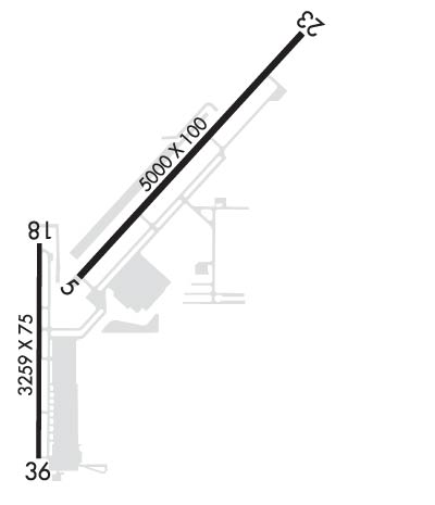
| Lat: N 2800.8 Long: W 08220.7 Elev: 21 Var: +04 Longest Runway: 5000 | ||
| AWOS: 121.12 CTAF: 122.7 | ||
| ||||||||||||||||||||||||||||||||||||||||||||
| ||||||||||||||||||||||||||||||||||||||||||||
| ||||||||||||||||||||||||||||||||||||||||||||
| Rwy | Rwy | |||||||
| 5000x100 | 5000' | 5000x100 | 4200' | 111.35 - 226° | ||||
| 3219x75 | 3219' | 3219x75 | 3219' | |||||
| Runway ID | Single Wheel | Double Wheel | Double Tandem Wheel | Dual Double Wheel |
| 05/23 | 34,500 | 63,000 | N/A | N/A |
| 18/36 | 59,000 | 84,000 | N/A | N/A |
| These numbers are Advisory and are not limits. The Airport Manager should have more accurate Weight Limits | ||||
 Airport Diagram might not be current. | |
| Facility Name: | TAMPA EXEC |
| City Name: | TAMPA |
| County: | HILLSBOROUGH |
| State abbrev: | FL |
| State Name: | FLORIDA |
| Ownership: | PUBLICLY OWNED |
| Use: | OPEN TO THE PUBLIC |
| Owner's Name: | HILLSBOROUGH COUNTY AVIATION AUTH |
| Address: | PO BOX 22287 |
| TAMPA, FL 33622 | |
| Owner's Phone: | 813-870-8711 |
| Manager's Name: | BRETT W FAY, C.M.; AIRPORT PHYSICAL ADDRESS: 6530 TAMPA EXECUTIVE AIRPORT RD, TAMPA, FL 33610 |
| Address: | PO BOX 22287 |
| TAMPA, FL 33622 | |
| Phone: | 813-870-8735 |
| FAA Region: | SOUTHERN |
| FAA Field Office: | ORL |
| Date | Sunrise | Sunset |
|---|---|---|
| 06/08/26 Monday | 6:32 | 20:25 |
| 06/09/26 Tuesday | 6:32 | 20:25 |
| 06/10/26 Wednesday | 6:32 | 20:25 |
| 06/11/26 Thursday | 6:32 | 20:26 |
| 06/12/26 Friday | 6:32 | 20:26 |
| 06/13/26 Saturday | 6:32 | 20:26 |
| 06/14/26 Sunday | 6:32 | 20:27 |
| 06/15/26 Monday | 6:33 | 20:27 |
| 06/16/26 Tuesday | 6:33 | 20:27 |
| 06/17/26 Wednesday | 6:33 | 20:28 |
| 06/18/26 Thursday | 6:33 | 20:28 |
| 06/19/26 Friday | 6:33 | 20:28 |
| 06/20/26 Saturday | 6:33 | 20:29 |
| 06/21/26 Sunday | 6:33 | 20:29 |
| Airport Attendance Schedule | MON-FRI 0700-2200, SAT-SUN 0700-1900 |
| Airport Status | OPERATIONAL (This Status can change at any time - please check NOTAMS) |
| Airport Lighting Schedule | ACTVT MALSR RWY 23; REIL RWY 05, 18, 36; PAPI RWY 05, 23, 18, 36; MIRL RWY 05/23, 18/36 - CTAF. |
| Airport Storage Available | Tie Downs, Hanger |
| Extra Services Available | Avionics, Charter, Flight Instruction, Aircraft Rental, Aircraft Sales |
| Wind Indicator | YES - (lighted) |
| Control Tower | NO |
| CTAF Frequency | 122.700 |
| Unicom Frequency | 122.700 |
| Rotating Beacon Color | WG |
| Segmented Circle | Y-L |
| Landing Fee | NO |
| Airport Inspected | STATE - performed by STATE AERONAUTICAL PERSONNEL |
| Inspection Date | 11/05/2025 |
| Type of Fuel Available | Grade 100LL, JET A (freeze point -40C) |
| Airframe Repair Service | MAJOR |
| Power Plant Repair Service | MAJOR |
| Latitude | N2800.8 |
| Longitude | W08220.7 (ESTIMATED) |
| Arpt Elevation | 21ft (SURVEYED) |
| Magnetic Variation | 04W |
| 6 miles E | of TAMPA |
| Traffic Pattern Altitude | |
| Sectional Chart | JACKSONVILLE |
| Operations (Reported) | Yearly | Avg. Daily |
|---|---|---|
| General Aviation Transient | 0 | 0 |
| General Aviation Local | 0 | 0 |
| Air Taxi | 0 | 0 |
| Commerical | 0 | 0 |
| Commuter | 0 | 0 |
| Military | 0 | 0 |
| Aircraft based on Field | |
|---|---|
| General Aviation Singles | 0 |
| General Aviation Multi | 0 |
| Jet Aircraft | 0 |
| General Aviation Helicopters | 0 |
| Military Aircraft | 0 |
| Gliders | 0 |
| Ultralights | 0 |
| FSS on field | NO |
| FSS tie-in | SAINT PETERSBURG |
| FSS Phone | 1-800-WX-BRIEF |
| Who issues Notams | VDF |
| Notam D service at airport | YES |
| ARTCC Name | JACKSONVILLE |
| Airport Certification | |
| Aircraft Rescue & Firefighting Index | None |
| Airport of Entry | No |
| Custom Landing Rights | No |
| Joint Civil/Military | No |
| Military Landing rights | No |
| NATIONAL PLAN OF INTEGRATED AIRPORT SYSTEMS (NPIAS) |
| GRANT AGREEMENTS UNDER FAAP/ADAP/AIP |
| ASSURANCES PURSUANT TO TITLE VI, CIVIL RIGHTS ACT OF 1964 |
| 24 HR ADVN NOTICE OR IMT REPORTING UPON LDG FOR ACFT EQUIPPED WITH WEATHER MODIFICATION OR GEOENGINEERING EQUIP. 813-870-8770 EXT. 3 |
| AFTER HRS FUEL AND SVCS AVBL. JET SINGLE POINT FUELING AND LAV SVS AVBL. CTC FBO ON CALL ATTENDANT AT 813-695-6097. |
| CTC GENERAL AVIATION DEPT AT 813-870-8770. |
| NOISE ABATEMENT PROCEDURES IN EFFECT FOR RY 18. NO TURNS UNTIL OVER INTERSTATE. NO TURNS BLO 400 FT AGL. |
| WHEN DEPG RWY 05 BE ALERT FOR MALSR LGT FIXTURE LCTD 55 FT BYD RWY END & 9 FT ABV RWY END ELEV. |
| FOR CD CTC TAMPA APCH ON 119.9. |
| TREES 510 FT NW OF RWY 5/23 FULL LEN LCTD INSIDE TRSN SFC. |
| BE ADZD OF SEAPLANE FLT ACTIVITY 3NM SE OF ARPT. |
Airport Communications & Frequencies:
| ||||||||||||||
| Runway: 05 | Runway: 23 | ||
| Mag heading: | 46° | Mag heading: | 226° |
| Rwy Slope: | .04% Up | Rwy Slope: | -.04% Down |
| Approach: | Approach: | ILS/DME | |
| Pattern: | Left Traffic | Pattern: | Left Traffic |
| Markings: | NONPRECISION INSTRUMENT | Markings: | PRECISION INSTRUMENT |
| Marking Condition: | GOOD | Marking Condition: | GOOD |
| Arresting Dev: | Arresting Dev: | ||
| Lat & Long: | N2800.7 W08220.9 | Lat. & Long.: | N2801.3 W08220.2 |
| Elev: | 19.2 ft. MSL | Elev: | 21.0 ft. MSL |
| TCH: | 45 ft. AGL | TCH: | 40 ft. AGL |
| Visual Glide Path: | 3.02 degrees | Visual Glide Path: | 3.10 degrees |
| Displaced Threshold: | No | Displaced Threshold: | 800 feet |
| Touchdown Zone: | YES | Touchdown Zone: | YES |
| Touchdown Elev.: | 21.0 feet | Touchdown Elev.: | 21.1 feet |
| Visual Glide Slope: | 2-Light PAPI on LEFT side of Runway | Visual Glide Slope: | 2-Light PAPI on LEFT side of Runway |
| RVR Equipment: | RVR Equipment: | ||
| RVV Equipment: | NO | RVV Equipment: | NO |
| Approach Lights: | Approach Lights: | MALSR - 1,400 foot medium intensity approach lighting system with runway alignment indicator lights | |
| REIL: | YES | REIL: | NO |
| Centerline Lights: | NO | Centerline Lights: | NO |
| Touchdown lights: | NO | Touchdown lights: | NO |
| Runway Category: | Runway with a Non-precision Approach having visibility minimums greater than 3/4 mile | Runway Category: | Precision Instrument Runway |
| Declared Distances: | TORA:4574' TODA:4574' ASDA:4956' LDA:4956' | Declared Distances: | TORA:5000' TODA:5000' ASDA:5000' LDA:4200' |
| Obstructions: | TREES | Obstructions: | ROAD |
| Marked: | NOT Marked/Lighted | Marked: | NOT Marked/Lighted |
| Clearance slope: | 40:1 | Clearance slope: | 6:1; RWY 23 APCH SLOPE 50:1 TO DTHR. |
| Obstruction height: | 43 feet AGL | Obstruction height: | 17 feet AGL |
| Dist. from runway: | 1955 feet | Dist. from runway: | 310 feet |
| Centerline offset: | 245 left of centerline | Centerline offset: | 500 feet left of centerline |
| Comments: | Comments: |
| Runway: 18 | Runway: 36 | ||
| Mag heading: | 184° | Mag heading: | 4° |
| Rwy Slope: | .00% Up | Rwy Slope: | .00% Down |
| Approach: | Approach: | ||
| Pattern: | Left Traffic | Pattern: | Left Traffic |
| Markings: | NONPRECISION INSTRUMENT | Markings: | NONPRECISION INSTRUMENT |
| Marking Condition: | GOOD | Marking Condition: | GOOD |
| Arresting Dev: | Arresting Dev: | ||
| Lat & Long: | N2800.8 W08221.0 | Lat. & Long.: | N2800.3 W08221.0 |
| Elev: | 18.4 ft. MSL | Elev: | 18.5 ft. MSL |
| TCH: | 41 ft. AGL | TCH: | 43 ft. AGL |
| Visual Glide Path: | 3.80 degrees | Visual Glide Path: | 3.40 degrees |
| Displaced Threshold: | No | Displaced Threshold: | No |
| Touchdown Zone: | YES | Touchdown Zone: | YES |
| Touchdown Elev.: | 18.9 feet | Touchdown Elev.: | 18.9 feet |
| Visual Glide Slope: | 4-Light PAPI on RIGHT side of Runway | Visual Glide Slope: | 2-Light PAPI on LEFT side of Runway |
| RVR Equipment: | RVR Equipment: | ||
| RVV Equipment: | NO | RVV Equipment: | NO |
| Approach Lights: | Approach Lights: | ||
| REIL: | YES | REIL: | YES |
| Centerline Lights: | NO | Centerline Lights: | NO |
| Touchdown lights: | NO | Touchdown lights: | NO |
| Runway Category: | Runway with a Non-precision Approach | Runway Category: | Runway with a Visual Approach |
| Declared Distances: | TORA:3219' TODA:3219' ASDA:3219' LDA:3219' | Declared Distances: | TORA:3219' TODA:3219' ASDA:3219' LDA:3219' |
| Obstructions: | BRUSH | Obstructions: | POLE |
| Marked: | NOT Marked/Lighted | Marked: | LIGHTED |
| Clearance slope: | 12:1; RWY 18 APRCH SLOPE 20:1 TO AER. | Clearance slope: | 22:1 |
| Obstruction height: | 23 feet AGL | Obstruction height: | 123 feet AGL |
| Dist. from runway: | 480 feet | Dist. from runway: | 2895 feet |
| Centerline offset: | 105 left of centerline | Centerline offset: | 20 feet left of centerline |
| Comments: | Comments: |
Thanks for using FltPlan.com
all rights reserved © 1999-2026 by Flight Plan LLC
