| SOUTHERN CALIFORNIA LOGISTICS VICTORVILLE CA |
| |
| Lat: N 3435.8 Long: W 11723.0 Elev: 2885 Var: -14 Longest Runway: 15050 | ||
| Dept. ATIS: 135.47 Arr. ATIS: 135.47 AWOS: 135.47 Ground: 124.45 Tower: 118.35 | ||
| ||||||||||||||||||||||||||||||||||||||||||||||||||||||||||||||||||||
| ||||||||||||||||||||||||||||||||||||||||||||||||||||||||||||||||||||
| ||||||||||||||||||||||||||||||||||||||||||||||||||||||||||||||||||||
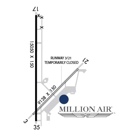
| Rwy | Rwy | |||||||
| 9138x150 | 9138' | 9138x150 | 9138' | |||||
| 15050x150 | 15050' | 108.75 - 166° | 15050x150 | 15050' | ||||
| Runway ID | Single Wheel | Double Wheel | Double Tandem Wheel | Dual Double Wheel |
| 03/21 | N/A | N/A | N/A | N/A |
| 17/35 | N/A | N/A | N/A | N/A |
| These numbers are Advisory and are not limits. The Airport Manager should have more accurate Weight Limits | ||||
 Airport Diagram might not be current. | |
| Facility Name: | SOUTHERN CALIFORNIA LOGISTICS |
| City Name: | VICTORVILLE |
| County: | SAN BERNARDINO |
| State abbrev: | CA |
| State Name: | CALIFORNIA |
| Ownership: | PUBLICLY OWNED |
| Use: | OPEN TO THE PUBLIC |
| Owner's Name: | SOUTHERN CA LOGISTICS ARPT AUTH |
| Address: | 18374 PHANTOM |
| VICTORVILLE, CA 92394 | |
| Owner's Phone: | 760-243-1900 |
| Manager's Name: | C. ERIC RAY; AIRPORT OPERATIONS - 760 243-1915 |
| Address: | SO CAL LOGISTICS AIRPORT AUTHORITY, 18374 PHANTOM WEST |
| VICTORVILLE, CA 92394 | |
| Phone: | 760-243-1915 |
| FAA Region: | WESTERN-PACIFIC |
| FAA Field Office: | LAX |

| Date | Sunrise | Sunset |
|---|---|---|
| 09/24/21 Friday | 6:39 | 18:44 |
| 09/25/21 Saturday | 6:40 | 18:42 |
| 09/26/21 Sunday | 6:40 | 18:41 |
| 09/27/21 Monday | 6:41 | 18:39 |
| 09/28/21 Tuesday | 6:42 | 18:38 |
| 09/29/21 Wednesday | 6:43 | 18:37 |
| 09/30/21 Thursday | 6:43 | 18:35 |
| 10/01/21 Friday | 6:44 | 18:34 |
| 10/02/21 Saturday | 6:45 | 18:32 |
| 10/03/21 Sunday | 6:46 | 18:31 |
| 10/04/21 Monday | 6:46 | 18:30 |
| 10/05/21 Tuesday | 6:47 | 18:28 |
| 10/06/21 Wednesday | 6:48 | 18:27 |
| 10/07/21 Thursday | 6:49 | 18:26 |
| Airport Attendance Schedule | 7 Days A Week 0600-2200 |
| Airport Status | OPERATIONAL (This Status can change at any time - please check NOTAMS) |
| Airport Lighting Schedule | WHEN ATCT CLSD ACTVT PAPI RWY 03, 21, 17 & 35; HIRL RWYS 03/21 & 17/35 - CTAF. |
| Airport Storage Available | Tie Downs |
| Extra Services Available | Air Freight, Air Ambulance, Cargo Handling |
| Wind Indicator | YES - (lighted) |
| Control Tower | YES |
| CTAF Frequency | 118.350; OPR HRS 2200-0600. |
| Unicom Frequency | |
| Rotating Beacon Color | CLEAR-GREEN (Light Land Airport) |
| Segmented Circle | YES |
| Landing Fee | NO |
| Airport Inspected | STATE - performed by FAA AIRPORTS FIELD PERSONNEL |
| Inspection Date | 11/06/2019 |
| Type of Fuel Available | Grade 100LL, JET A (freeze point -40C) |
| Airframe Repair Service | MAJOR |
| Power Plant Repair Service | MAJOR |
| Latitude | N3435.8 |
| Longitude | W11723.0 (ESTIMATED) |
| Arpt Elevation | 2885ft (SURVEYED) |
| Magnetic Variation | 14E |
| 5 miles NW | of VICTORVILLE |
| Traffic Pattern Altitude | |
| Sectional Chart | LOS ANGELES |
| Operations (Reported) | Yearly | Avg. Daily |
|---|---|---|
| General Aviation Transient | 7141 | 20 |
| General Aviation Local | 9902 | 27 |
| Air Taxi | 1983 | 5 |
| Commerical | 307 | 1 |
| Commuter | 0 | 0 |
| Military | 3495 | 10 |
| Aircraft based on Field | |
|---|---|
| General Aviation Singles | 1 |
| General Aviation Multi | 0 |
| Jet Aircraft | 62 |
| General Aviation Helicopters | 4 |
| Military Aircraft | 0 |
| Gliders | 0 |
| Ultralights | 0 |
| FSS on field | NO |
| FSS tie-in | RIVERSIDE |
| FSS Phone | 1-800-WX-BRIEF |
| Who issues Notams | VCV |
| Notam D service at airport | YES |
| ARTCC Name | LOS ANGELES |
| Airport Certification | ARFF INDEX A, WITH ARFF INDEX E AVBL WITH 24 HRS PPR; CALL OPNS (760) 243-1915. |
| Aircraft Rescue & Firefighting Index | AIRPORT HAS A CERTIFICATE UNDER CFR PART 139 |
| Airport of Entry | No |
| Custom Landing Rights | No; US CUSTOMS USER FEE ARPT. |
| Joint Civil/Military | No |
| Military Landing rights | YES |
| NATIONAL PLAN OF INTEGRATED AIRPORT SYSTEMS (NPIAS) |
| GRANT AGREEMENTS UNDER FAAP/ADAP/AIP |
| ASSURANCES PURSUANT TO TITLE VI, CIVIL RIGHTS ACT OF 1964 |
| THIS AIRPORT HAS BEEN SURVEYED BY THE NATIONAL GEODETIC SURVEY. |
| AVOID OVERFLIGHT OF SILVER LAKES 10 MILES NORTH FOR NOISE ABATEMENT. |
| PTN OF TWY A BTN TWY C AND RWY 21, PTN OF TWY C BTN TWY A AND TWY B, PTN OF TWY C BTN TWYS C1 AND C2, PTN OF TWY E BTN TWY E1 AND TWY D, RWY 17 THLD, AND RWY 35 THLD ARE NOT VISIBLE AREAS FROM THE ATCT. VCV ATCT UNA TO PRVD ATC SVCS TO ACFT IN THESE NON-VISIBLE AREAS. |
| TWY U NOT AVBL FOR GA OR ACR USE. NOT LGTD. |
| PORTION OF RWY 17 NORTH 5000 FT ARE NOT VISIBLE AREAS FROM THE ATCT. |
| WHEN ATCT CLSD, FOR CD CTC JOSHUA APCH AT 661-277-3843. |
| FOR ACFT FUEL OR MAINT CALL (760) 246-7794 OR USE FREQ 131.975 |
Airport Communications & Frequencies:
| ||||||||||||||||||||||
| Runway: 03 | Runway: 21 | ||
| Mag heading: | 31° | Mag heading: | 211° |
| Rwy Slope: | -.37% Down | Rwy Slope: | .37% Up |
| Approach: | Approach: | ||
| Pattern: | Right Traffic | Pattern: | Left Traffic |
| Markings: | NONPRECISION INSTRUMENT | Markings: | NONPRECISION INSTRUMENT |
| Marking Condition: | GOOD | Marking Condition: | GOOD |
| Arresting Dev: | Arresting Dev: | ||
| Lat & Long: | N3435.0 W11723.3 | Lat. & Long.: | N3436.0 W11722.0 |
| Elev: | 2877.6 ft. MSL | Elev: | 2844.0 ft. MSL |
| TCH: | 75 ft. AGL | TCH: | 75 ft. AGL |
| Visual Glide Path: | 3.00 degrees | Visual Glide Path: | 3.00 degrees |
| Displaced Threshold: | No | Displaced Threshold: | No |
| Touchdown Zone: | YES | Touchdown Zone: | YES |
| Touchdown Elev.: | 2877.6 feet | Touchdown Elev.: | 2857.8 feet |
| Visual Glide Slope: | 4-Light PAPI on LEFT side of Runway | Visual Glide Slope: | 4-Light PAPI on LEFT side of Runway |
| RVR Equipment: | RVR Equipment: | ||
| RVV Equipment: | NO | RVV Equipment: | NO |
| Approach Lights: | Approach Lights: | ||
| REIL: | NO | REIL: | NO |
| Centerline Lights: | NO | Centerline Lights: | NO |
| Touchdown lights: | NO | Touchdown lights: | NO |
| Runway Category: | Runway with a Visual Approach | Runway Category: | Runway with a Visual Approach |
| Declared Distances: | TORA:9138' TODA:9138' ASDA:9138' LDA:9138' | Declared Distances: | TORA:9138' TODA:9138' ASDA:9138' LDA:9138' |
| Runway: 17 | Runway: 35 | ||
| Mag heading: | 166° | Mag heading: | 346° |
| Rwy Slope: | .46% Up | Rwy Slope: | -.46% Down |
| Approach: | LOC/GS | Approach: | |
| Pattern: | Right Traffic | Pattern: | Left Traffic |
| Markings: | PRECISION INSTRUMENT | Markings: | PRECISION INSTRUMENT |
| Marking Condition: | GOOD | Marking Condition: | GOOD |
| Arresting Dev: | Arresting Dev: | ||
| Lat & Long: | N3437.3 W11723.2 | Lat. & Long.: | N3434.8 W11723.2 |
| Elev: | 2815.3 ft. MSL | Elev: | 2885.1 ft. MSL |
| TCH: | 75 ft. AGL | TCH: | 65 ft. AGL |
| Visual Glide Path: | 3.00 degrees | Visual Glide Path: | 3.00 degrees |
| Displaced Threshold: | No | Displaced Threshold: | No |
| Touchdown Zone: | YES | Touchdown Zone: | YES |
| Touchdown Elev.: | 2824.7 feet | Touchdown Elev.: | 2885.1 feet |
| Visual Glide Slope: | 4-Light PAPI on LEFT side of Runway | Visual Glide Slope: | 4-Light PAPI on LEFT side of Runway |
| RVR Equipment: | TOUCHDOWN | RVR Equipment: | ROLLOUT |
| RVV Equipment: | NO | RVV Equipment: | NO |
| Approach Lights: | Approach Lights: | ||
| REIL: | YES | REIL: | YES |
| Centerline Lights: | NO | Centerline Lights: | NO |
| Touchdown lights: | NO | Touchdown lights: | NO |
| Runway Category: | Precision Instrument Runway | Runway Category: | Runway with a Visual Approach |
| Declared Distances: | TORA:15050' TODA:15050' ASDA:15050' LDA:15050' | Declared Distances: | TORA:15050' TODA:15050' ASDA:15050' LDA:15050' |
Thanks for using FltPlan.com
all rights reserved © 1999-2021 by Flight Plan LLC