
| VICTORIA RGNL VICTORIA TX |
| |
| Lat: N 2851.3 Long: W 09655.1 Elev: 115 Var: -04 Longest Runway: 9111 | ||
| Dept. ATIS: 119.02 Arr. ATIS: 119.02 AWOS: 119.02 Ground: 120.52 Tower: 126.07 | ||
| ||||||
| ||||||
|
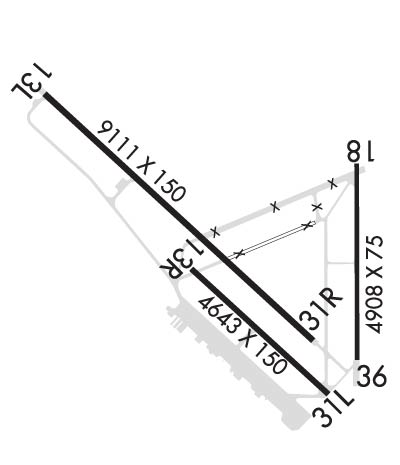
| Rwy | Rwy | |||||||
| 9111x150 | 9111' | 111.50 - 128° | 9111x150 | 9111' | ||||
| 4908x75 | 4908' | 4908x75 | 4908' | |||||
| Runway ID | Single Wheel | Double Wheel | Double Tandem Wheel | Dual Double Wheel |
| 13/31 | 28,000 | 49,000 | 87,000 | N/A |
| 18/36 | 28,000 | 49,000 | 87,000 | N/A |
| H1 | N/A | N/A | N/A | N/A |
| These numbers are Advisory and are not limits. The Airport Manager should have more accurate Weight Limits | ||||
 Airport Diagram might not be current. | |
| Facility Name: | VICTORIA RGNL |
| City Name: | VICTORIA |
| County: | VICTORIA |
| State abbrev: | TX |
| State Name: | TEXAS |
| Ownership: | PUBLICLY OWNED |
| Use: | OPEN TO THE PUBLIC |
| Owner's Name: | COUNTY OF VICTORIA |
| Address: | VICTORIA CO COURTHOUSE RM 102 |
| VICTORIA, TX 77901 | |
| Owner's Phone: | 361-575-4558 |
| Manager's Name: | V. LENNY LLERENA |
| Address: | 609 FOSTER FIELD DR SUITE F |
| VICTORIA, TX 77904 | |
| Phone: | 361-578-2704 |
| FAA Region: | SOUTHWEST |
| FAA Field Office: | TEX |
| Date | Sunrise | Sunset |
|---|---|---|
| 09/24/21 Friday | 7:17 | 19:22 |
| 09/25/21 Saturday | 7:17 | 19:21 |
| 09/26/21 Sunday | 7:18 | 19:20 |
| 09/27/21 Monday | 7:19 | 19:18 |
| 09/28/21 Tuesday | 7:19 | 19:17 |
| 09/29/21 Wednesday | 7:20 | 19:16 |
| 09/30/21 Thursday | 7:20 | 19:15 |
| 10/01/21 Friday | 7:21 | 19:14 |
| 10/02/21 Saturday | 7:21 | 19:12 |
| 10/03/21 Sunday | 7:22 | 19:11 |
| 10/04/21 Monday | 7:22 | 19:10 |
| 10/05/21 Tuesday | 7:23 | 19:09 |
| 10/06/21 Wednesday | 7:23 | 19:08 |
| 10/07/21 Thursday | 7:24 | 19:07 |
| Airport Attendance Schedule | MON-FRI 0600-2000, SAT 0600-2000, SUN 0600-1800 |
| Airport Status | OPERATIONAL (This Status can change at any time - please check NOTAMS) |
| Airport Lighting Schedule | HIRL RWY 13/31 PRESET LOW INTST, TO INCR INTST & ACTVT MALSR RWY 13 - CTAF. MIRL RWY 18/36 PRESET MED INTST ONLY. PAPI RWYS 31, 18 & 36 OPR CONSLY. |
| Airport Storage Available | Tie Downs, Hanger |
| Extra Services Available | Air Freight, Flight Instruction |
| Wind Indicator | YES - (lighted) |
| Control Tower | YES |
| CTAF Frequency | 126.075 |
| Unicom Frequency | 122.700 |
| Rotating Beacon Color | CLEAR-GREEN (Light Land Airport) |
| Segmented Circle | YES |
| Landing Fee | NO |
| Airport Inspected | FEDERAL - performed by FAA AIRPORTS FIELD PERSONNEL |
| Inspection Date | 02/20/2020 |
| Type of Fuel Available | Grade 100LL, JET A (freeze point -40C) |
| Airframe Repair Service | MINOR |
| Power Plant Repair Service | MINOR |
| Latitude | N2851.3 |
| Longitude | W09655.1 (ESTIMATED) |
| Arpt Elevation | 115ft (SURVEYED) |
| Magnetic Variation | 04E |
| 5 miles NE | of VICTORIA |
| Traffic Pattern Altitude | TPA FOR JETS 1600 FT; FOR TURBO PROP, LIGHT AIRCRAFT, ROTORCRAFT 1100 FT AGL |
| Sectional Chart | HOUSTON |
| Operations (Reported) | Yearly | Avg. Daily |
|---|---|---|
| General Aviation Transient | 5693 | 16 |
| General Aviation Local | 1987 | 5 |
| Air Taxi | 3814 | 10 |
| Commerical | 0 | 0 |
| Commuter | 0 | 0 |
| Military | 45928 | 126 |
| Aircraft based on Field | |
|---|---|
| General Aviation Singles | 29 |
| General Aviation Multi | 7 |
| Jet Aircraft | 3 |
| General Aviation Helicopters | 2 |
| Military Aircraft | 0 |
| Gliders | 0 |
| Ultralights | 0 |
| FSS on field | NO |
| FSS tie-in | MONTGOMERY COUNTY |
| FSS Phone | 1-800-WX-BRIEF |
| Who issues Notams | VCT |
| Notam D service at airport | YES |
| ARTCC Name | HOUSTON |
| Airport Certification | AIRPORT RECEIVING SCHEDULED AIR CARRIER SERVICE FROM CARRIERS CERTIFICATED BY THE CIVIL AERONAUTICS BOARD; BETWEEN 2200-0700 ALL UNSCHEDULED ACR OPNS WITH MORE THAN 9 PSGR SEATS CONTACT ARFF 361-582-5889. |
| Aircraft Rescue & Firefighting Index | AIRPORT HAS A CERTIFICATE UNDER CFR PART 139 |
| Airport of Entry | No |
| Custom Landing Rights | No |
| Joint Civil/Military | No |
| Military Landing rights | YES |
| NATIONAL PLAN OF INTEGRATED AIRPORT SYSTEMS (NPIAS) |
| GRANT AGREEMENTS UNDER FAAP/ADAP/AIP |
| SURPLUS PROPERTY AGREEMENT UNDER PUBLIC LAW 289 |
| ASSURANCES PURSUANT TO TITLE VI, CIVIL RIGHTS ACT OF 1964 |
| FOR CD IF UNA TO CTC ON FSS FREQ, CTC HOUSTON ARTCC AT 281-230-5622. |
| AD AP BIRD ACT |
Airport Communications & Frequencies:
| |||||||||||||||||||
| Runway: 13 | Runway: 31 | ||
| Mag heading: | 128° | Mag heading: | 308° |
| Rwy Slope: | -.13% Down | Rwy Slope: | .13% Up |
| Approach: | ILS/DME | Approach: | |
| Pattern: | Left Traffic | Pattern: | Right Traffic |
| Markings: | PRECISION INSTRUMENT | Markings: | NONPRECISION INSTRUMENT |
| Marking Condition: | GOOD | Marking Condition: | GOOD |
| Arresting Dev: | Arresting Dev: | ||
| Lat & Long: | N2851.8 W09656.0 | Lat. & Long.: | N2850.8 W09654.8 |
| Elev: | 115.1 ft. MSL | Elev: | 103.5 ft. MSL |
| TCH: | TCH: | 55 ft. AGL | |
| Visual Glide Path: | Visual Glide Path: | 3.00 degrees | |
| Displaced Threshold: | No | Displaced Threshold: | No |
| Touchdown Zone: | YES | Touchdown Zone: | YES |
| Touchdown Elev.: | 115.2 feet | Touchdown Elev.: | 106.4 feet |
| Visual Glide Slope: | Visual Glide Slope: | 4-Light PAPI on LEFT side of Runway | |
| RVR Equipment: | RVR Equipment: | ||
| RVV Equipment: | NO | RVV Equipment: | NO |
| Approach Lights: | MALSR - 1,400 foot medium intensity approach lighting system with runway alignment indicator lights | Approach Lights: | |
| REIL: | NO | REIL: | NO |
| Centerline Lights: | NO | Centerline Lights: | NO |
| Touchdown lights: | NO | Touchdown lights: | NO |
| Runway Category: | Precision Instrument Runway | Runway Category: | Runway with a Non-precision Approach having visibility minimums greater than 3/4 mile |
| Declared Distances: | TORA:9111' TODA:9111' ASDA:9111' LDA:9111' | Declared Distances: | TORA:9111' TODA:9111' ASDA:9111' LDA:9111' |
| Runway: 18 | Runway: 36 | ||
| Mag heading: | 176° | Mag heading: | 356° |
| Rwy Slope: | -.07% Down | Rwy Slope: | .07% Up |
| Approach: | Approach: | ||
| Pattern: | Left Traffic | Pattern: | Left Traffic |
| Markings: | BASIC | Markings: | BASIC |
| Marking Condition: | FAIR | Marking Condition: | FAIR |
| Arresting Dev: | Arresting Dev: | ||
| Lat & Long: | N2851.5 W09654.6 | Lat. & Long.: | N2850.7 W09654.6 |
| Elev: | 106.4 ft. MSL | Elev: | 102.9 ft. MSL |
| TCH: | 40 ft. AGL | TCH: | 40 ft. AGL |
| Visual Glide Path: | 3.00 degrees | Visual Glide Path: | 3.00 degrees |
| Displaced Threshold: | No | Displaced Threshold: | No |
| Touchdown Zone: | YES | Touchdown Zone: | YES |
| Touchdown Elev.: | 106.6 feet | Touchdown Elev.: | 105.9 feet |
| Visual Glide Slope: | 2-Light PAPI on LEFT side of Runway | Visual Glide Slope: | 2-Light PAPI on LEFT side of Runway |
| RVR Equipment: | RVR Equipment: | ||
| RVV Equipment: | NO | RVV Equipment: | NO |
| Approach Lights: | Approach Lights: | ||
| REIL: | YES; REIL OTS INDEFLY. | REIL: | YES; REIL OTS INDEFLY. |
| Centerline Lights: | NO | Centerline Lights: | NO |
| Touchdown lights: | NO | Touchdown lights: | NO |
| Runway Category: | Runway with a Visual Approach | Runway Category: | Runway with a Visual Approach |
| Declared Distances: | TORA:4908' TODA:4908' ASDA:4908' LDA:4908' | Declared Distances: | TORA:4908' TODA:4908' ASDA:4908' LDA:4908' |
| Obstructions: | FENCE | Obstructions: | POLE |
| Marked: | NOT Marked/Lighted | Marked: | NOT Marked/Lighted |
| Clearance slope: | 33:1 | Clearance slope: | 46:1 |
| Obstruction height: | 6 feet AGL | Obstruction height: | 29 feet AGL |
| Dist. from runway: | 400 feet | Dist. from runway: | 1544 feet |
| Centerline offset: | Centerline offset: | 44 feet left of centerline | |
| Comments: | Comments: |
Thanks for using FltPlan.com
all rights reserved © 1999-2021 by Flight Plan LLC
