
| NUT TREE VACAVILLE CA |
| |
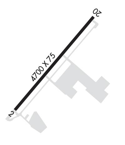
| Lat: N 3822.7 Long: W 12157.7 Elev: 117 Var: -13 Longest Runway: 4700 | ||
| AWOS: 134.75 CTAF: 122.85 | ||
| ||||||||||||||||||||||||||||||||||||||||||||
| ||||||||||||||||||||||||||||||||||||||||||||
| ||||||||||||||||||||||||||||||||||||||||||||
| Rwy | Rwy | |||||||
| 4700x75 | 4700' | 4700x75 | 4700' | |||||
| Runway ID | Single Wheel | Double Wheel | Double Tandem Wheel | Dual Double Wheel |
| 02/20 | 30,000 | N/A | N/A | N/A |
| These numbers are Advisory and are not limits. The Airport Manager should have more accurate Weight Limits | ||||
 Airport Diagram might not be current. | |
| Facility Name: | NUT TREE |
| City Name: | VACAVILLE |
| County: | SOLANO |
| State abbrev: | CA |
| State Name: | CALIFORNIA |
| Ownership: | PUBLICLY OWNED |
| Use: | OPEN TO THE PUBLIC |
| Owner's Name: | COUNTY OF SOLANO |
| Address: | 580 TEXAS ST |
| FAIRFIELD, CA 94533 | |
| Owner's Phone: | 707-784-6100 |
| Manager's Name: | OFFICE COORDINATOR: MARY GONZALES |
| Address: | 301 COUNTY AIRPORT ROAD |
| VACAVILLE, CA 95688 | |
| Phone: | 707-469-4600 |
| FAA Region: | WESTERN-PACIFIC |
| FAA Field Office: | SFO |
| Date | Sunrise | Sunset |
|---|---|---|
| 09/24/21 Friday | 6:57 | 19:02 |
| 09/25/21 Saturday | 6:58 | 19:00 |
| 09/26/21 Sunday | 6:59 | 18:59 |
| 09/27/21 Monday | 7:00 | 18:57 |
| 09/28/21 Tuesday | 7:01 | 18:56 |
| 09/29/21 Wednesday | 7:02 | 18:54 |
| 09/30/21 Thursday | 7:03 | 18:52 |
| 10/01/21 Friday | 7:03 | 18:51 |
| 10/02/21 Saturday | 7:04 | 18:49 |
| 10/03/21 Sunday | 7:05 | 18:48 |
| 10/04/21 Monday | 7:06 | 18:46 |
| 10/05/21 Tuesday | 7:07 | 18:45 |
| 10/06/21 Wednesday | 7:08 | 18:43 |
| 10/07/21 Thursday | 7:09 | 18:42 |
| Airport Attendance Schedule | MON-FRI 1400-0100Z++ |
| Airport Status | OPERATIONAL (This Status can change at any time - please check NOTAMS) |
| Airport Lighting Schedule | AFT 2200 ACTVT MIRL & PARALLEL TWY LGTS RY 02/20; PAPI & REIL RYS 02 & 20 - CTAF. |
| Airport Storage Available | Tie Downs |
| Extra Services Available | Charter, Flight Instruction, Aircraft Rental, Aircraft Sales |
| Wind Indicator | YES - (lighted) |
| Control Tower | NO |
| CTAF Frequency | 122.850 |
| Unicom Frequency | |
| Rotating Beacon Color | CLEAR-GREEN (Light Land Airport) |
| Segmented Circle | YES |
| Landing Fee | NO |
| Airport Inspected | STATE - performed by STATE AERONAUTICAL PERSONNEL |
| Inspection Date | 04/16/2019 |
| Type of Fuel Available | Grade 100LL, JET A (freeze point -40C) |
| Airframe Repair Service | MAJOR |
| Power Plant Repair Service | MAJOR |
| Latitude | N3822.7 |
| Longitude | W12157.7 (ESTIMATED) |
| Arpt Elevation | 116ft (SURVEYED) |
| Magnetic Variation | 13E |
| 2 miles NE | of VACAVILLE |
| Traffic Pattern Altitude | |
| Sectional Chart | SAN FRANCISCO |
| Operations (Reported) | Yearly | Avg. Daily |
|---|---|---|
| General Aviation Transient | 60000 | 164 |
| General Aviation Local | 40000 | 110 |
| Air Taxi | 1500 | 4 |
| Commerical | 0 | 0 |
| Commuter | 0 | 0 |
| Military | 0 | 0 |
| Aircraft based on Field | |
|---|---|
| General Aviation Singles | 88; INCLUDES 4 GYROPLANES. |
| General Aviation Multi | 5 |
| Jet Aircraft | 0 |
| General Aviation Helicopters | 0 |
| Military Aircraft | 0 |
| Gliders | 0 |
| Ultralights | 0 |
| FSS on field | NO |
| FSS tie-in | RANCHO MURIETA |
| FSS Phone | 1-800-WX-BRIEF |
| Who issues Notams | VCB |
| Notam D service at airport | YES |
| ARTCC Name | OAKLAND |
| Airport Certification | |
| Aircraft Rescue & Firefighting Index | None |
| Airport of Entry | No |
| Custom Landing Rights | No |
| Joint Civil/Military | No |
| Military Landing rights | YES |
| NATIONAL PLAN OF INTEGRATED AIRPORT SYSTEMS (NPIAS) |
| GRANT AGREEMENTS UNDER FAAP/ADAP/AIP |
| ASSURANCES PURSUANT TO TITLE VI, CIVIL RIGHTS ACT OF 1964 |
| NO TURNS TO XW BLW 800 FT MSL; RMN W OF INSTA HWY FOR RWY 20, NOISE SENSITIVE AREA W OF ARPT. |
| TWY LGTS ON PARL TWY ONLY. |
| RWY 02 CALM WIND RWY. |
| FOR CD CTC OAKLAND ARTCC AT 510-745-3380. |
Airport Communications & Frequencies:
| ||||||||||||
| Runway: 02 | Runway: 20 | ||
| Mag heading: | 21° | Mag heading: | 201° |
| Rwy Slope: | -.09% Down | Rwy Slope: | .09% Up |
| Approach: | Approach: | ||
| Pattern: | Left Traffic | Pattern: | Right Traffic |
| Markings: | NONPRECISION INSTRUMENT | Markings: | NONPRECISION INSTRUMENT |
| Marking Condition: | GOOD | Marking Condition: | GOOD |
| Arresting Dev: | Arresting Dev: | ||
| Lat & Long: | N3822.4 W12157.9 | Lat. & Long.: | N3823.0 W12157.4 |
| Elev: | 115.8 ft. MSL | Elev: | 111.7 ft. MSL |
| TCH: | 27 ft. AGL | TCH: | 27 ft. AGL |
| Visual Glide Path: | 3.75 degrees | Visual Glide Path: | 3.75 degrees |
| Displaced Threshold: | No | Displaced Threshold: | No |
| Touchdown Zone: | YES | Touchdown Zone: | YES |
| Touchdown Elev.: | 116.9 feet | Touchdown Elev.: | 116.7 feet |
| Visual Glide Slope: | 2-Light PAPI on LEFT side of Runway | Visual Glide Slope: | 2-Light PAPI on LEFT side of Runway |
| RVR Equipment: | RVR Equipment: | ||
| RVV Equipment: | NO | RVV Equipment: | NO |
| Approach Lights: | Approach Lights: | ||
| REIL: | YES | REIL: | YES |
| Centerline Lights: | NO | Centerline Lights: | NO |
| Touchdown lights: | NO | Touchdown lights: | NO |
| Runway Category: | Runway with a Visual Approach | Runway Category: | Runway with a Visual Approach |
| Declared Distances: | Declared Distances: | ||
| Obstructions: | TREE | Obstructions: | |
| Marked: | NOT Marked/Lighted | Marked: | |
| Clearance slope: | 25:1 | Clearance slope: | 50:1 |
| Obstruction height: | 52 feet AGL | Obstruction height: | |
| Dist. from runway: | 1450 feet | Dist. from runway: | |
| Centerline offset: | 200 right of centerline | Centerline offset: | |
| Comments: | Comments: |
Thanks for using FltPlan.com
all rights reserved © 1999-2021 by Flight Plan LLC
